MyTopo
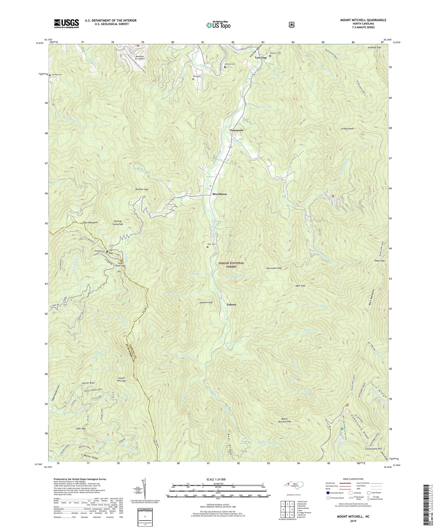
Mount Mitchell North Carolina US Topo Map
Couldn't load pickup availability
Also explore the Mount Mitchell Forest Service Topo of this same quad for updated USFS data
2022 topographic map quadrangle Mount Mitchell in the state of North Carolina. Scale: 1:24000. Based on the newly updated USGS 7.5' US Topo map series, this map is in the following counties: Yancey, Buncombe. The map contains contour data, water features, and other items you are used to seeing on USGS maps, but also has updated roads and other features. This is the next generation of topographic maps. Printed on high-quality waterproof paper with UV fade-resistant inks.
Quads adjacent to this one:
West: Barnardsville
Northwest: Bald Creek
North: Burnsville
Northeast: Micaville
East: Celo
Southeast: Old Fort
South: Montreat
Southwest: Craggy Pinnacle
This map covers the same area as the classic USGS quad with code o35082g3.
Contains the following named places: Allen Cemetery, Arwood Cemetery, Balsam Cone, Bearwallow Knob, Bearwallow Stand Ridge, Bee Branch, Beech Nursery Creek, Beech Nursery Gap, Big Andy Ridge, Big Butt, Big Fork Ridge, Big Pine Mountain, Big Poplar Creek, Big Tom, Black Mountains, Black Ridge, Blue Knob, Blue Ridge, Blue Sea Creek, Blue Sea Falls, Brush Fence Ridge, Burleson Branch, Burleson Cemetery, Callaway Mountain, Camp Alice, Cane River Gap, Cattail Creek, Cattail Creek Community, Cattail Peak, Commissary Hill, Commissary Ridge, Corner Rock, Coxcomb Mountain, Deep Gap, Deer Mountain, Elk Fork, Eskota, Falling Water Branch, Flat Spring Knob, Fork Ridge, Glassmine Ridge, Grassy Knob, Grassy Knob Ridge, Grassy Ridge, Haney Creek, High Knob, Hurricane Gap, Indian Fork, Ivy Gap, Jumpoff Gap, Laurel Branch, Laurel Ridge, Licklog Mountain, Light Gap, Little Andy Creek, Little Butt, Little Piney Ridge, Locust Pen Gap, Low Gap, Low Gap Hollow, Mill Creek Ridge, Mitchell Creek, Mitchell Falls, Mitchell Ridge, Moody Mountain, Mount Craig, Mount Mitchell, Mount Mitchell State Park, Mountain Air Airport, Mountain Wilderness Airpark, Murchison, Murchison Church, North Fork Cattail Creek, Ogle Branch, Ogle Creek, Ogle Gap, Ogle Meadows, Ogle Ridge, Panther Gap, Panther Knob, Penland Cemetery, Pensacola, Pensacola Volunteer Fire Department, Pisgah National Forest, Point Misery, Potato Hill, Raven Fork, Ray Cemetery, Rolling Camp Gap, Sharptop, Shateen Branch, Shateen Gap, Slickrock Mountain, South Fork Cattail Creek, Stack Rock, Straight Creek, Sugarcamp Creek, Timber Creek, Timber Ridge, Township of Pensacola, Tudy Creek, Turkey Ridge, Vixen Post Office, Walker Falls, Weedy Cove Knob, Weedy Knob, West Yancey Volunteer Fire Department Station 3, Wheeler Cemetery, Wilson Ridge, Winter Star Ridge