MyTopo
Cove Creek Gap North Carolina US Topo Map
Couldn't load pickup availability
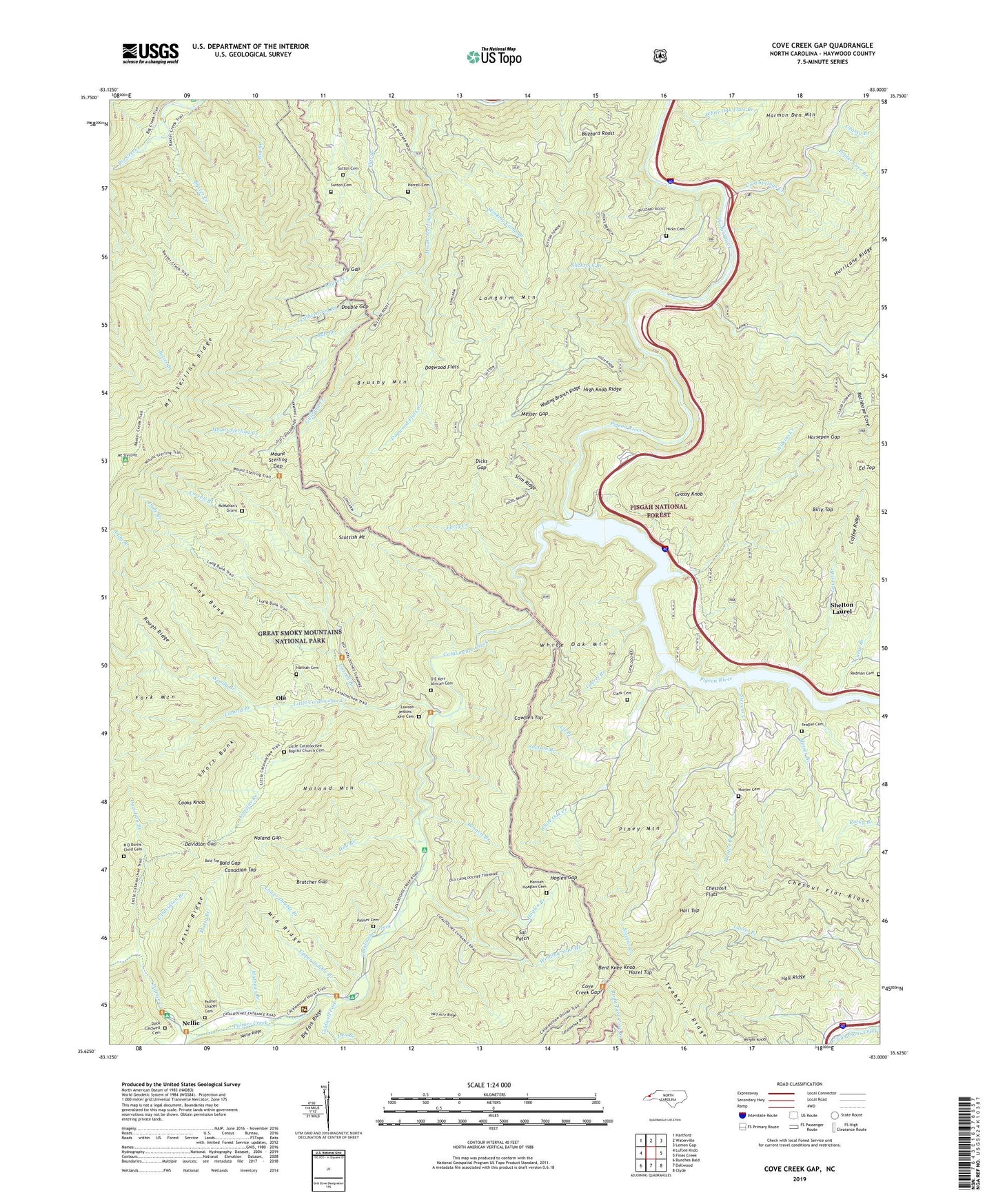
2019 topographic map quadrangle Cove Creek Gap in the state of North Carolina. Scale: 1:24000. Based on the newly updated USGS 7.5' US Topo map series, this map is in the following counties: Haywood. The map contains contour data, water features, and other items you are used to seeing on USGS maps, but also has updated roads and other features. This is the next generation of topographic maps. Printed on high-quality waterproof paper with UV fade-resistant inks.
Quads adjacent to this one:
West: Luftee Knob
Northwest: Hartford
North: Waterville
Northeast: Lemon Gap
East: Fines Creek
Southeast: Clyde
South: Dellwood
Southwest: Bunches Bald
Contains the following named places: Andy Branch, Asbury Trail, Bald Gap, Bald Top, Ball Branch, Baxter Creek, Baxter Creek Trail, Bennett Branch, Bent Knee Knob, Big Branch Trail, Billy Top, Bratcher Gap, Brushy Mountain, Buzzard Roost, Caldwell Fork, Camp Branch, Canadian Top, Cataloochee, Cataloochee Campground, Cataloochee Creek, Cataloochee Group Camp, Cataloochee Horse Camp, Cataloochee Ranger Station, Chesnut Flat Ridge, Chestnut Flats, Clark Cemetery, Coffee Ridge, Coggins Branch, Cold Springs Creek, Conard Branch, Cooks Knob, Correll Branch, Cotton Patch, Cove Creek Gap, Cowpen Top, Davidson Branch, Davidson Gap, Den Branch, Dicks Branch, Dicks Gap, Dock Caldwell Cemetery, Dogwood Flats, Dogwood Flats Creek, Double Gap, Dude Branch, Early Creek, Fork Mountain, Gilliland Creek, Grassy Branch, Grassy Knob, H D Burris Child Cemetery, Half Acre Ridge, Hall Branch, Hall Ridge, Hall Top, Hannah - Hoaglan Cemetery, Hannah Cemetery, Harrell Cemetery, Hazel Top, Hicks Branch, Hicks Cemetery, High Knob Ridge, Hoglen Branch, Hoglen Gap, Horsepen Gap, Hunter Branch, Hunter Cemetery, Hurricane Creek, Ivy Gap, Jesse Ridge, L Davidson Branch, Laurel Branch, Lawson Jenkins - Kerr Cemetery, Leatherwood Branch, Little Cataloochee Baptist Church Cemetery, Little Cataloochee Church, Little Cataloochee Creek, Liz Branch, Long Bunk, Longarm Mountain, Lower Double Branch, Mathews Branch, McMahan's Grave, Messer Branch, Messer Gap, Middle Ridge, Mossy Branch, Mount Sterling, Mount Sterling Gap, Mount Sterling Lookout, Nellie, Noland Gap, Noland Mountain, O E Kerr African Cemetery, Ola, Palmer Cemetery, Palmer Chapel, Palmer Chapel Cemetery, Palmer Creek, Palmer Creek Trail, Piney Mountain, Poplar Cove Branch, Rathbone Cove, Redman Cemetery, Rough Fork, Rough Ridge, Sal Patch, Scottish Mount, Shelton Laurel, Short Bunk, Slickrock Branch, Slim Ridge, Snelson Branch, Stevens Creek, Stinking Camp Branch, Sutton Cemetery, Sutton Top Lookout, Teaberry Ridge, Teague Cemetery, Toms Branch, Township of White Oak, Upper Double Branch, Wading Branch Ridge, Walters Dam, Waterville Lake, White Oak Church, White Oak Community Center, White Oak Creek, White Oak Flats Branch, White Oak Mountain, Wilkins Creek, Winding Stair Branch, Woody Branch, Wright Branch, Wright Knob