MyTopo
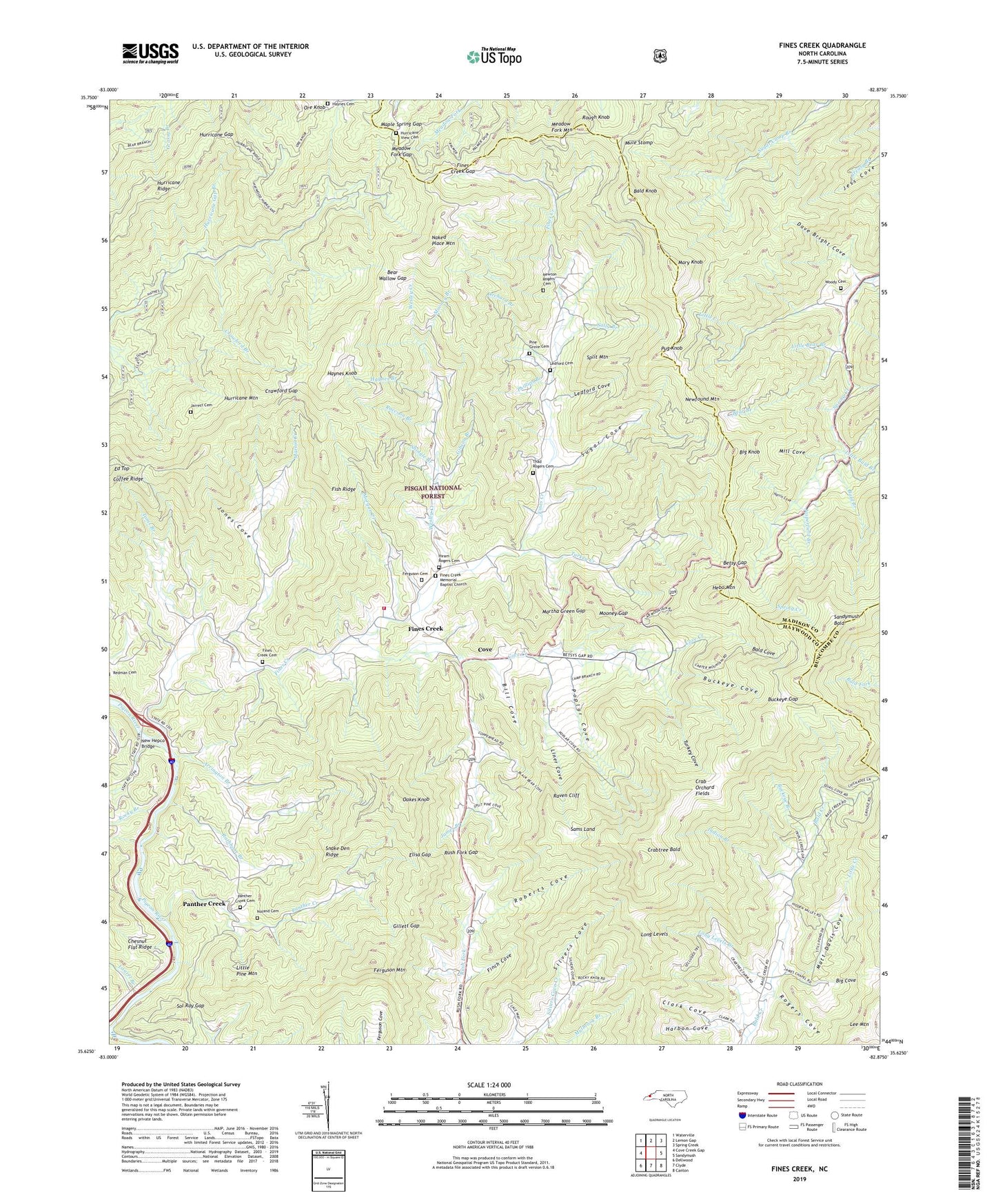
Fines Creek North Carolina US Topo Map
Couldn't load pickup availability
Also explore the Fines Creek Forest Service Topo of this same quad for updated USFS data
2022 topographic map quadrangle Fines Creek in the state of North Carolina. Scale: 1:24000. Based on the newly updated USGS 7.5' US Topo map series, this map is in the following counties: Haywood, Madison, Buncombe. The map contains contour data, water features, and other items you are used to seeing on USGS maps, but also has updated roads and other features. This is the next generation of topographic maps. Printed on high-quality waterproof paper with UV fade-resistant inks.
Quads adjacent to this one:
West: Cove Creek Gap
Northwest: Waterville
North: Lemon Gap
Northeast: Spring Creek
East: Sandymush
Southeast: Canton
South: Clyde
Southwest: Dellwood
This map covers the same area as the classic USGS quad with code o35082f8.
Contains the following named places: Arrington Branch, Bald Branch, Bald Cove, Bald Knob, Ball City Church, Bear Branch, Bear Wallow Gap, Belmont Baptist Church, Belmont Church, Betsy Gap, Big Cove, Big Knob, Bill Cove, Buckeye Branch, Buckeye Cove, Buckeye Gap, Clark Cove, Cove, Cove Creek, Crab Orchard Fields, Crabtree Bald, Crawford Branch, Crawford Gap, Dave Bright Cove, Ed Top, Elisa Gap, Ferguson Cemetery, Ferguson Mountain, Finch Cove, Fines Creek, Fines Creek Gap, Fines Creek Memorial Baptist Church, Fines Creek Memorial Baptist Church Cemetery, Fines Creek School, Fines Creek United Methodist Church, Fines Creek United Methodist Church Cemetery, Fines Creek Volunteer Fire Department, Fish Ridge, Gibson Branch, Gillett Gap, Harbon Cove, Harmon Den Wildlife Management Area, Harris Cove, Haynes Branch, Haynes Cemetery, Haynes Knob, Haywood Gap, Hebo Mountain, Hepco, Hurricane Gap, Hurricane Gap Branch, Hurricane Mountain, Hurricane Ridge, Hurricane View Cemetery, Indian Branch, Jacks Branch, James Branch, James Chapel, James Chapel School, Jarrett Cemetery, Jasperfield Branch, John Branch, Jonathans Creek, Jones Cove, Laurel Branch, Leatherwood Branch, Ledford Cemetery, Ledford Cove, Liner Cove, Little Bald Branch, Little Bear Branch, Little Creek, Little Pine Mountain, Long Levels, Long Levels Branch, Maple Spring Gap, Martha Green Gap, Martin Creek, Mary Knob, Matt Davis Cove, Meadow Fork Gap, Meadow Fork Mountain, Mill Cove, Mooney Branch, Mooney Gap, Morgan Creek, Mule Stomp, Naked Place Mountain, New Hepco Bridge, Newfound Mountain, Newton Rogers Cemetery, Noland Cemetery, Oakes Knob, Orchard Branch, Ore Knob, Palm, Panther Creek, Panther Creek Baptist Church, Panther Creek Cemetery, Panther Creek School, Phillips Branch, Pine Grove Cemetery, Pine Grove Church, Poplar Cove, Pug Knob, Raccoon Branch, Rathbone Branch, Raven Cliff, Roberts Cove, Rockhouse Branch, Rocky Branch, Rogers Cove, Rough Knob, Rush Fork Gap, Sally Branch, Sams Land, Sandymush Bald, Shelton Laurel Chapel, Shingle Branch, Silvers Cove, Snake Den Ridge, Sol Ray Gap, Split Mountain, Sugar Cove, Teague, Thad Rogers Cemetery, Toms Branch, Township of Fines Creek, Turkey Cove, Turkey Creek, Wesley Creek, Woody Cemetery, ZIP Code: 28721