MyTopo
Clyde North Carolina US Topo Map
Couldn't load pickup availability
Also explore the Clyde Forest Service Topo of this same quad for updated USFS data
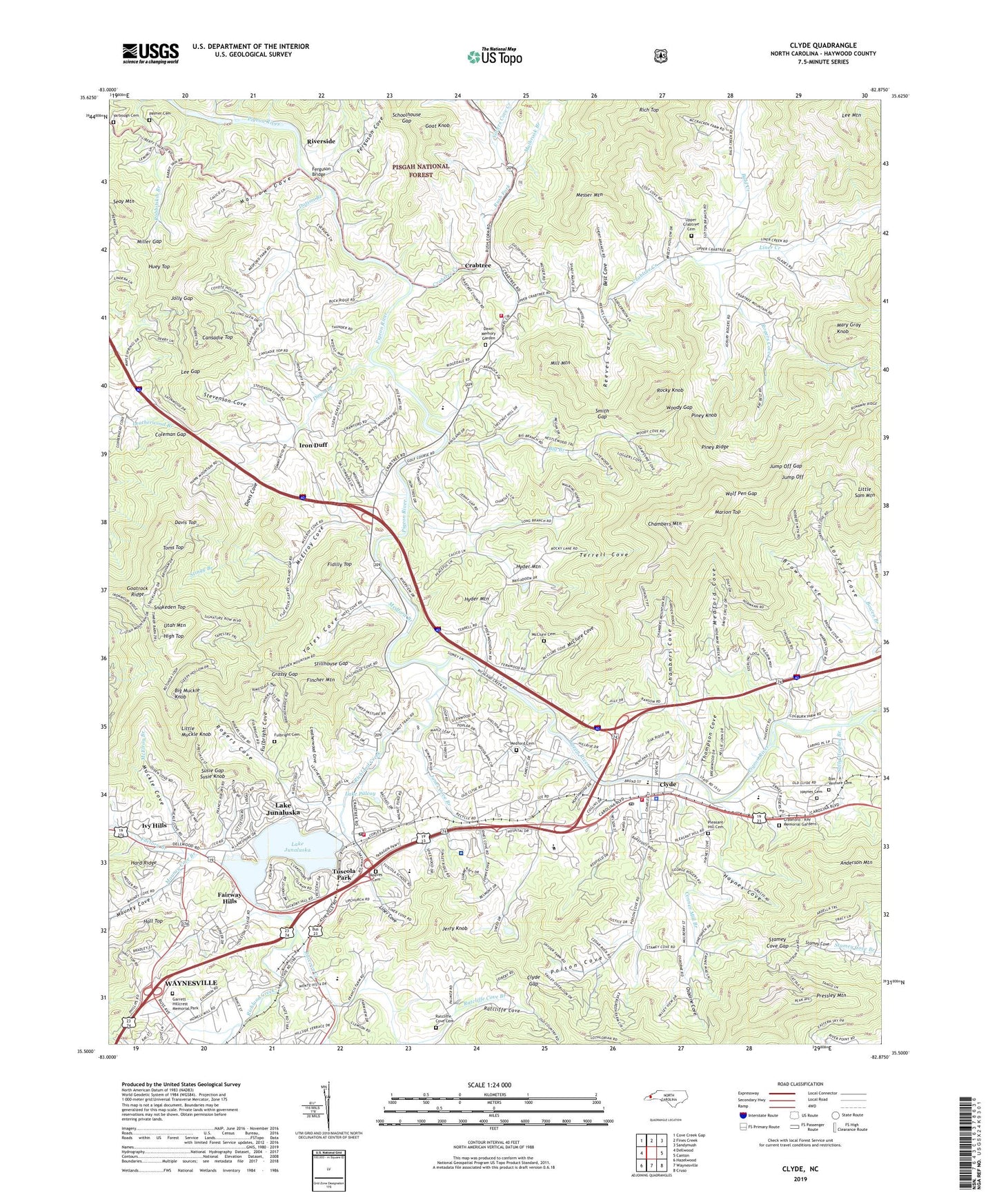
2022 topographic map quadrangle Clyde in the state of North Carolina. Scale: 1:24000. Based on the newly updated USGS 7.5' US Topo map series, this map is in the following counties: Haywood. The map contains contour data, water features, and other items you are used to seeing on USGS maps, but also has updated roads and other features. This is the next generation of topographic maps. Printed on high-quality waterproof paper with UV fade-resistant inks.
Quads adjacent to this one:
West: Dellwood
Northwest: Cove Creek Gap
North: Fines Creek
Northeast: Sandymush
East: Canton
Southeast: Cruso
South: Waynesville
Southwest: Hazelwood
This map covers the same area as the classic USGS quad with code o35082e8.
Contains the following named places: Anderson Mountain, Antioch Church, Bald Creek, Barberville Church, Best Cove, Big Branch, Big Muckle Knob, Bon - A - Venture Cemetery, Brown Cove, Broyhill Lake, Broyhill Lake Dam, Cansadie Top, Central Church, Central Haywood High School, Chambers Branch, Chambers Cove, Chambers Mountain, Clyde, Clyde Gap, Clyde Police Department, Clyde Post Office, Clyde Volunteer Fire Department, Coleman Gap, Conner Mill Branch, Crabtree, Crabtree - Iron Duff Volunteer Fire Department, Crabtree Creek, Crabtree Iron Duff High School, Crawford - Ray Memorial Gardens, Davis Chapel, Davis Cove, Davis Top, Dawn Branch, Dawn Memory Garden, Dotson Branch, East Waynesville Church, Factory Branch, Fairway Hills, Faith Church, Fellowship Church, Ferguson Bridge, Ferguson Cove, Fidilly Top, Fincher Chapel, Fincher Mountain, Fulbright Cemetery, Fulbright Cove, Garrett - Hillcrest Memorial Park, Goat Knob, Goatrock Ridge, Grassy Gap, Hall Top, Haynes Cemetery, Haynes Cove, Haywood County, Haywood Regional Medical Center, High Top, Hill Top Mission, Huey Top, Hyder Mountain, Iron Duff, Ivy Hills, Jerry Knob, Jolly Gap, Jones Cove, Jones Cove Branch, Jorden Branch, Jump Off, Jump Off Gap, Junaluska Community Volunteer Fire Department, Junaluska Elementary School, Lake Junaluska, Lake Junaluska Census Designated Place, Lake Junaluska Dam, Lake Junaluska Post Office, Lake Palcoy, Leatherwood Cove, Lee Gap, Liberty Church, Liner Cove, Liner Creek, Little Muckle Knob, Little Sam Mountain, Long Branch, Long Chapel, Louisa Chapel, Maple Grove Church, Marion Top, Marrow Cove, Marshall Ash Pond, Marshall Ash Pond Dam, Mary Gray Knob, Mauney Cove, Mauney Cove Branch, McClure Cemetery, McClure Cove, McElroy Branch, McElroy Cove, Medford Branch, Medford Cemetery, Medford Cove, Messer Mountain, Mill Mountain, Miller Gap, Mount Zion Church, Muckle Cove, Mulbrook Branch, North Carolina State Highway Patrol Troop G District 5, Old Thickety Church, Osborne Cove, Palmer Cemetery, Patton Branch, Piney Knob, Piney Ridge, Pleasant Hill Cemetery, Poison Cove, Pressley Mountain, Rabbitskin Branch, Raccoon Creek, Ratcliffe Cove Branch, Ratcliffe Cove Cemetery, Reeves Cemetery, Reeves Cove, Rich Top, Richland Creek, Riverside, Rock Spring Church, Rocky Knob, Rogers Cove, Rogers Cove Creek, Rush Fork, Sally Haynes Branch, Schoolhouse Gap, Seay Mountain, Shelton Branch, Silvers Cove Creek, Skyland Camp, Smith Gap, Snakeden Top, Soapstone Gap, Sorrels Cove, Stamey Cove Gap, Stevenson Cove, Stillhouse Gap, Stingy Branch, Structure Number Two C Dam, Structure Number Two C Lake, Susie Gap, Susie Knob, Terrell Cove, Thickety Church, Thompson Cove, Toms Top, Town of Clyde, Township of Clyde, Township of Crabtree, Township of Iron Duff, Tuscola High School, Tuscola Park, Upper Crabtree Cemetery, Utah Mountain, West Wind Airport, WHCC-AM (Waynesville), Wolf Branch, Wolf Pen Gap, Woodland Church, Woody Gap, WQNS-FM (Waynesville), Yarbough Cemetery, Yates Cove, ZIP Code: 28745