MyTopo
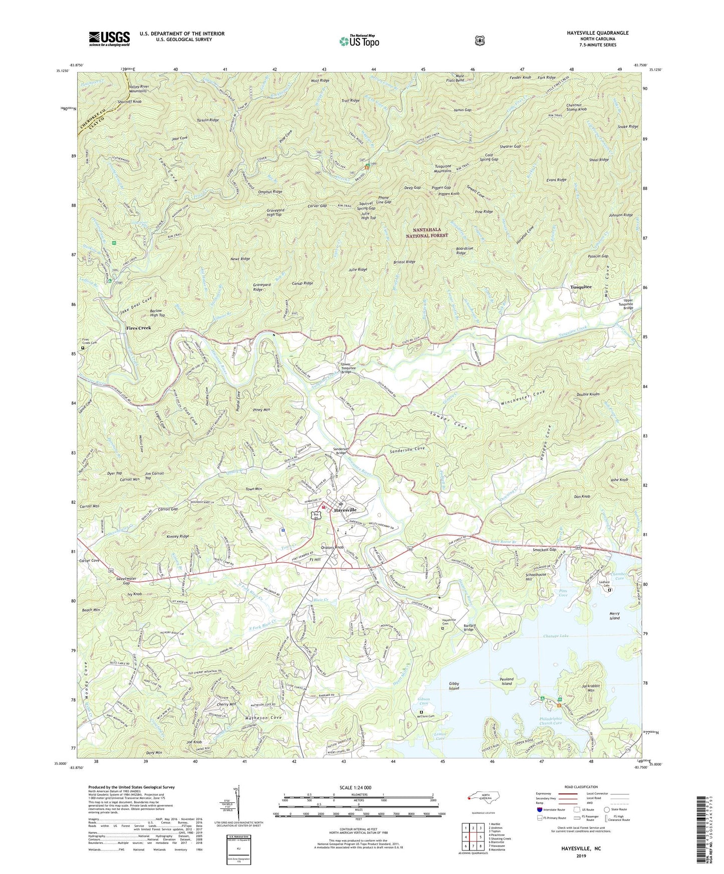
Hayesville North Carolina US Topo Map
Couldn't load pickup availability
Also explore the Hayesville Forest Service Topo of this same quad for updated USFS data
2022 topographic map quadrangle Hayesville in the state of North Carolina. Scale: 1:24000. Based on the newly updated USGS 7.5' US Topo map series, this map is in the following counties: Clay, Cherokee. The map contains contour data, water features, and other items you are used to seeing on USGS maps, but also has updated roads and other features. This is the next generation of topographic maps. Printed on high-quality waterproof paper with UV fade-resistant inks.
Quads adjacent to this one:
West: Peachtree
Northwest: Marble
North: Andrews
Northeast: Topton
East: Shooting Creek
Southeast: Macedonia
South: Hiawassee
Southwest: Blairsville
This map covers the same area as the classic USGS quad with code o35083a7.
Contains the following named places: Allbone Branch, Armstrong Cove, Armstrong Dock, Ashe Knob, Barlow High Top, Barnard Bridge, Bee Branch, Blair Creek, Boardtree Branch, Boardtree Ridge, Bob Branch, Bob Prater Branch, Bristol Branch, Bristol Camp, Bristol Hunter Camp, Bristol Ridge, Buckner Branch, Buckner Ridge, Byers Branch, Caesar Austin Branch, Canup Ridge, Carroll Gap, Carroll Mountain, Carver Creek, Carver Gap, Chambers Cove, Chatuge Dam, Cherry Mountain, Chestnut Stomp Knob, Clay County, Clay County Emergency Medical Service, Clay County Fire and Rescue Squad, Clay County Park, Clay County Sheriff's Office, Cold Spring Gap, Coleman Creek, Coot Cove, Crawford Branch, Dan Knob, Deep Gap, Dick Branch, Double Knobs, Downing Creek, Downing Creek Church, Dyer Top, Evans Branch, Evans Ridge, Fender Knob, Fires Creek, Fires Creek Camp, Fires Creek Cemetery, Fires Creek Church, Fires Creek Picnic Area, Flintspring Branch, Fort Hill, Game Branch, George W Truett Camp, Gibby Island, Gibson Cove, Graveyard High Top, Graveyard Ridge, Greasy Creek, Haigler Camp Branch, Hayesville, Hayesville Cemetery, Hayesville Church, Hayesville Elementary School, Hayesville High School, Hayesville Post Office, Hayesville Reservoir, Hickory Cove Creek, Hinton Rural Life Center, Holden Cove, Horselot Cove, Huskins Branch, Hyatt Mill Creek, Ivy Knob, Jackrabbit Campground, Jackrabbit Mountain, Jackrabbit Mountain Picnic Area, Jake Cove, Jake Deal Cove, Jim Carroll Top, Joe Knob, John Reese Branch, Johnson Creek, Julie High Top, Julie Ridge, Ketron Camp Branch, Kimball Gap, Kimsey Branch, Kimsey Ridge, Lance Cove, Laurel Creek, Leatherwood Branch, Leatherwood Falls, Ledford Branch, Ledford Chapel, Ledford Chapel Methodist Cemetery, Left Prong Johnson Creek, Lemon Cove, Licklog Creek, Little Fires Creek, Logan Cove, Logan Cove Branch, Lower Tusquitee Bridge, Lyon Branch, Martin Hill Church, Matheson Cove, McClure Cemetery, Meadow Grove Church, Merry Island, Mob Branch, Moody Cove, Moss Church, Mule Flats Bend, Mull Cove, Myers Chapel, Nantahala Purchase Unit, Newt Ridge, North Fork Blair Creek, Oak Forest Church, Oakview Church, Old House Branch, Omphus Ridge, Orators Knob, Owenby Cove, Padgett Branch, Passmore Branch, Patterson Branch, Peckerwood Branch, Pendergrass Branch, Penland Island, Philadelphia Church, Philadelphia Church Cove, Phone Line Gap, Pigpen Branch, Pigpen Gap, Pigpen Knob, Pine Cove, Pine Grove Church, Pine Ridge, Piney Mountain, Pitts Cove, Polecat Gap, Poplar Cove, Qually Creek, Rockhouse Creek, Rocky Cove Branch, Rocky Creek, Saddle Dam 1, Saddle Dam 2, Saddle Dam 3, Sanderson Bridge, Sanderson Cove, Sawyer Cove, Schoolhouse Branch, Schoolhouse Hill, Sewell Cove, Shady Grove Church, Shearer Creek, Shearer Gap, Shewbird, Shiloh Church, Shoal Branch, Shoal Ridge, Shortoff Knob, Smackass Gap, Snake Branch, Snake Ridge, South Fork Blair Creek, Squirrel Spring Gap, Stable Branch, Stillhouse Branch, Sweetwater Gap, Tarkiln Ridge, Tom Cove, Town Creek, Town Mountain, Town of Hayesville, Township of Hayesville, Township of Hiawassee, Trail Ridge, Truett Memorial Church, Tusquitee, Tusquitee Creek, Upper Tusquitee Bridge, Venus Gap, Walnut Cove, Webb Creek, Wheeler Branch, Winchester Cove, Wolfpen Branch