MyTopo
Lenoir North Carolina US Topo Map
Couldn't load pickup availability
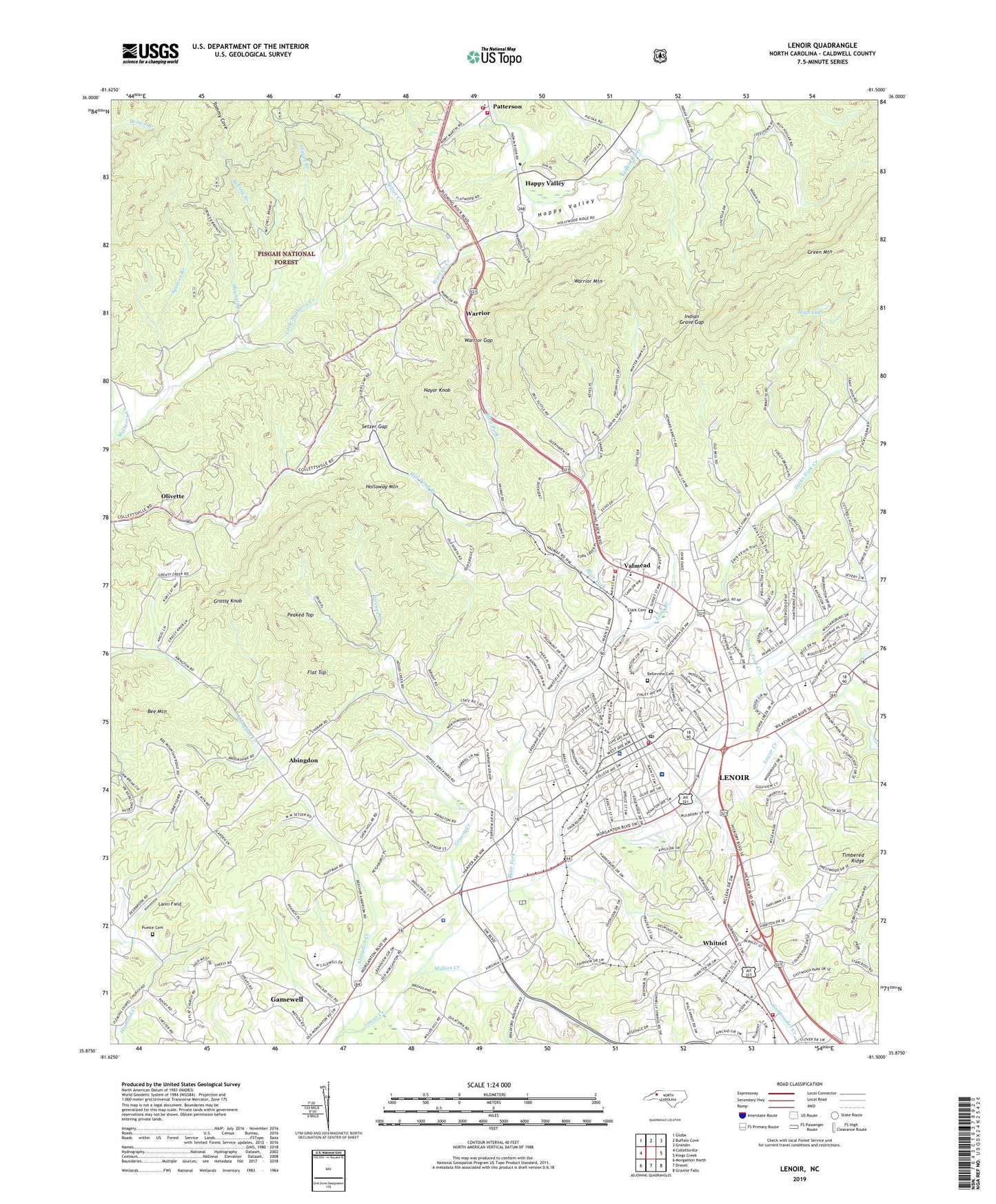
2019 topographic map quadrangle Lenoir in the state of North Carolina. Scale: 1:24000. Based on the newly updated USGS 7.5' US Topo map series, this map is in the following counties: Caldwell. The map contains contour data, water features, and other items you are used to seeing on USGS maps, but also has updated roads and other features. This is the next generation of topographic maps. Printed on high-quality waterproof paper with UV fade-resistant inks.
Quads adjacent to this one:
West: Collettsville
Northwest: Globe
North: Buffalo Cove
Northeast: Grandin
East: Kings Creek
Southeast: Granite Falls
South: Drexel
Southwest: Morganton North
Contains the following named places: Abingdon, Abingdon Creek, Bee Mountain, Belleview Cemetery, Blackwelder Hospital, Blair Fork, British Woods, Bushtown School, Caldwell County, Caldwell County Emergency Medical Services, Caldwell County Sheriff's Office, Caldwell Memorial Hospital, Calvary Baptist Church, Causby Gneiss Quarry, Central Baptist Church, Charlesmont, City of Lenoir, Clark Cemetery, Coffey Branch, College Avenue Baptist Church, Corola Hills, Cross Roads Shopping Center, Davenport Elementary School, District 9 School, Dula Chapel, East Flat Church, East Harper Elementary School, Eastwood Village Shopping Center, Fairview Church, Flat Top, Glenburine, Grand View Park, Grand View Park Church, Grassy Knob, Greasy Creek, Happy Valley, Happy Valley School, Harpertown School, Harrisburg Baptist Church, Hartley Hill Church, Heritage Hills, Hibriten Church, High Lake, High Lake Dam, Holloway Mountain, Honey Hill, Hood Chapel, Indian Grave Gap, Indian Hills, Lanni Field, Lenoir, Lenoir Crossings, Lenoir Crossings Shopping Center, Lenoir Fire Department Station 1, Lenoir Fire Department Station 2, Lenoir First Baptist Church, Lenoir Golf Club, Lenoir Mall, Lenoir Police Department, Lenoir Post Office, Lenoir Rescue Squad, Little Mulberry Creek, Long Branch, Longford Church, Loving Branch, Lower Creek School, Meadowbrook Baptist Church, Mill Pond Branch, Miller Hill Church, Millers Creek, Mitchell Branch, Mount View Church, Mulberry Recreation Center, Nayor Knob, Nazareth Church, Oakwood Church, Olivette, Patterson, Patterson Post Office, Patterson Volunteer Fire Department, Peaked Top, Pinewood, Pisgah Church, Puette Cemetery, Queens Acres, Rock Creek Church, Saint Francis of Assisi Catholic Church, Setzer Creek, Setzer Creek Church, Setzer Gap, Shiloh Church, Spencer Branch, Stapps Branch, Temple Church, Thrift Shopping Center, Township of Lenoir, Township of Lower Creek, Tranquil Hill, Tremont Park, Valmead, Valmead School, Valmead Volunteer Fire Department, Viewmont Recreation Center, Warrior, Warrior Creek, Warrior Gap, Warrior Mountain, West Caldwell High School, West Lenoir, West Lenoir Baptist Church, West Lenoir Elementary School, Whitnel, Whitnel First Baptist Church, Whitnel School, William Lenoir Middle School, WJRI-AM (Lenoir), WKGX-AM (Lenoir), Worship Point Church, Yadkin Church, Zacks Fork Baptist Church, Zacks Fork Creek, ZIP Code: 28645