MyTopo
Little Switzerland North Carolina US Topo Map
Couldn't load pickup availability
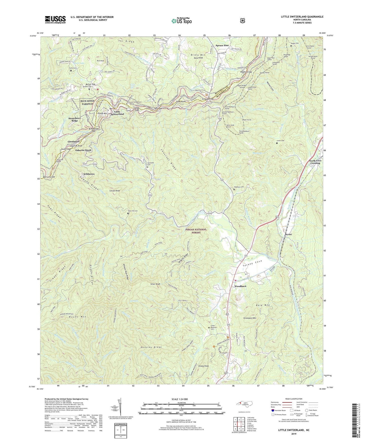
2019 topographic map quadrangle Little Switzerland in the state of North Carolina. Scale: 1:24000. Based on the newly updated USGS 7.5' US Topo map series, this map is in the following counties: McDowell, Mitchell. The map contains contour data, water features, and other items you are used to seeing on USGS maps, but also has updated roads and other features. This is the next generation of topographic maps. Printed on high-quality waterproof paper with UV fade-resistant inks.
Quads adjacent to this one:
West: Celo
Northwest: Micaville
North: Spruce Pine
Northeast: Linville Falls
East: Ashford
Southeast: Marion East
South: Marion West
Southwest: Old Fort
Contains the following named places: Armstrong Creek, Bad Fork, Bald Mountain Trail, Bartlett Creek, Bearwallow Gap, Betsy Ridge, Biddix Cemetery, Bird Ridge Tunnel, Black Mountain Church, Blue Ridge Gemstone Mine and Campground, Briery Mountain, Buchanan Creek, Buckner Dam, Buckner Lake, Burnett Cemetery, Caney Branch, Chestnut Grove Church, Chestnut Ridge, Collis Branch, Collis Cemetery, Conley Branch, Conley Memorial Church, Cow Creek, Cox Creek, Cox Creek Church, Deer Lick Branch, Deer Lick Gap, Deerstand Creek, Dula Knob, Firescald Creek, First Rocky Tunnel, First Washburn Tunnel, Gillespie Gap, Glenlaurel, Gooch Gap, Grassy Creek Falls, Grassy Knob, Grassy Mountain, Graveyard Mountain, Green Mountain Cemetery, Harris Creek, Hensley Ridge, Hickory Bottom Branch, Hicks Chapel, Hollifield Cemetery, Laurel Lake, Limekiln Creek, Little Switzerland, Little Switzerland Post Office, Little Switzerland Tunnel, Locust Knob, Long Branch, Lonon Branch, Lonon Cemetery, Lower Bridle Tunnel, Lower Pine Tunnel, Lynn Gap, Mace Branch, Martin Branch, McCall Gap, Muddy Branch, Museum of North Carolina Minerals, North Carolina State Fish Hatchery, North Cove Church, North Cove Crossing, North Fork Grassy Creek, ODear Creek, Osborne Knob, Parkway Fire and Rescue Station 3, Pepper Creek, Pepper Creek Church, Pompey Ridge, Pups Branch, Quinn Knob Tunnel, Rag Creek, Rattlesnake Branch, Reddick Branch, Rich Knob, Roaring Fork, Rocky Siding, Roses Creek, Rough Ridge, Sandy Gap, Second Rocky Tunnel, Second Washburn Tunnel, Sevier, Sheehan Creek, Silver Knob, Slim Creek, Snipes Tunnel, Snow Hill Cemetery, Sol Ridge, South Fork Roses Creek, Speedy Tunnel, Stony Knob, Strawberry Ridge, Swafford Gap, Sycamore Branch, The Loop, Third Washburn Tunnel, Three Mile Creek, Township of North Cove, Turkey Cove, Turkey Cove Church, Upper Bridle Tunnel, Upper Pine Tunnel, Van Noy Branch, Walnut Cove, Washburn Cemetery, Wiggins Ridge, Wildacres, Wildacres Tunnel, Witness Rock Ridge, Woodlawn, Woodlawn - Sevier Volunteer Fire Department, Woodlawn Work Center, Woods Mountain, Woods Mountain Lookout Tower, Yancey Pond, ZIP Code: 28749