MyTopo
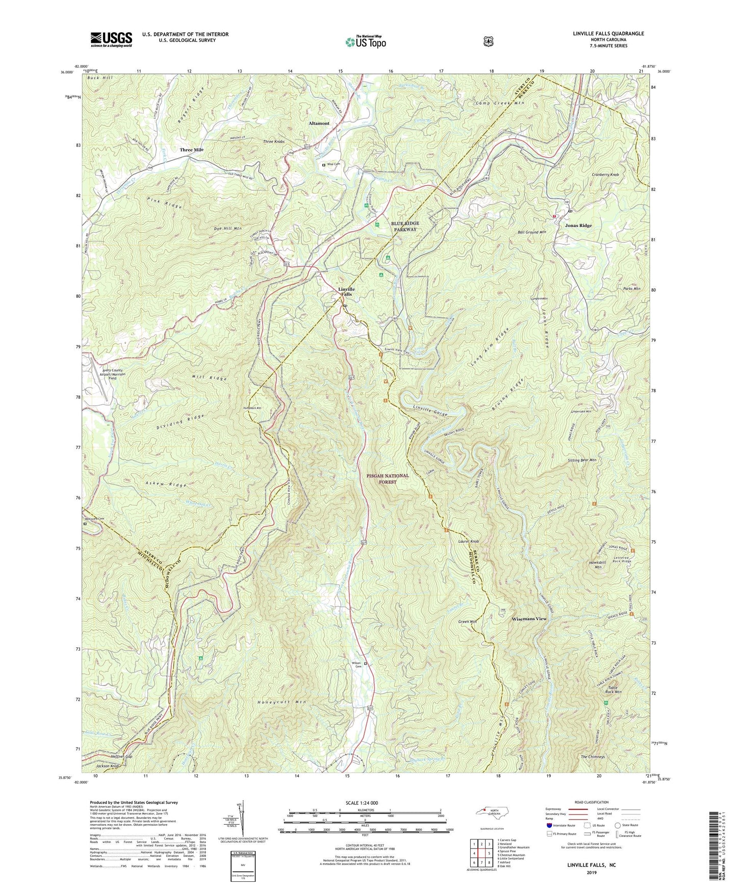
Linville Falls North Carolina US Topo Map
Couldn't load pickup availability
Also explore the Linville Falls Forest Service Topo of this same quad for updated USFS data
2022 topographic map quadrangle Linville Falls in the state of North Carolina. Scale: 1:24000. Based on the newly updated USGS 7.5' US Topo map series, this map is in the following counties: Avery, Burke, McDowell, Mitchell. The map contains contour data, water features, and other items you are used to seeing on USGS maps, but also has updated roads and other features. This is the next generation of topographic maps. Printed on high-quality waterproof paper with UV fade-resistant inks.
Quads adjacent to this one:
West: Spruce Pine
Northwest: Carvers Gap
North: Newland
Northeast: Grandfather Mountain
East: Chestnut Mountain
Southeast: Oak Hill
South: Ashford
Southwest: Little Switzerland
This map covers the same area as the classic USGS quad with code o35081h8.
Contains the following named places: Altamont, Askew Ridge, Avery County Airport/Morrison Field, Ball Ground Mountain, Bear Den Campground, Brushy Creek, Brushy Ridge, Bull Branch, Burke County Emergency Services Station 5, Camp Creek, Camp Creek Mountain, Canoe Branch, Concord Church, Cranberry Knob, Dividing Ridge, Doe Hill Mountain, Fork Creek, Gingercake Mountain, Green Mountain, Green Valley Church, Gulf Branch, Harris Creek, Hawksbill Mountain, Heffner Gap, Honeycutt Mountain, Humpback Mountain, Jackson Knob, Jonas Ridge, Jonas Ridge Post Office, Jonas Ridge School Building, Jonas Ridge Volunteer Fire and Rescue Department, Laurel Branch, Laurel Creek, Laurel Knob, Lettered Rock Ridge, Linville Falls, Linville Falls Post Office, Linville Gorge Wilderness, Linville Mountain, Long Arm Mountain, Long Arm Ridge, Loop, McKinney Cemetery, Mill Ridge, North Carolina Outward Bound, Parks Mountain, Pink Ridge, Pisgah Church, Pond Branch, Sitting Bear Mountain, Stamey Branch, Table Rock Mountain, Table Rock Picnic Area, The Chimneys, Three Knobs, Three Mile, Toe River Township, Township of Jonas Ridge, Walnut Grove Church, White Oak Creek, Wilson Cemetery, Wise Cemetery, Wisemans View, ZIP Code: 28647