MyTopo
Micaville North Carolina US Topo Map
Couldn't load pickup availability
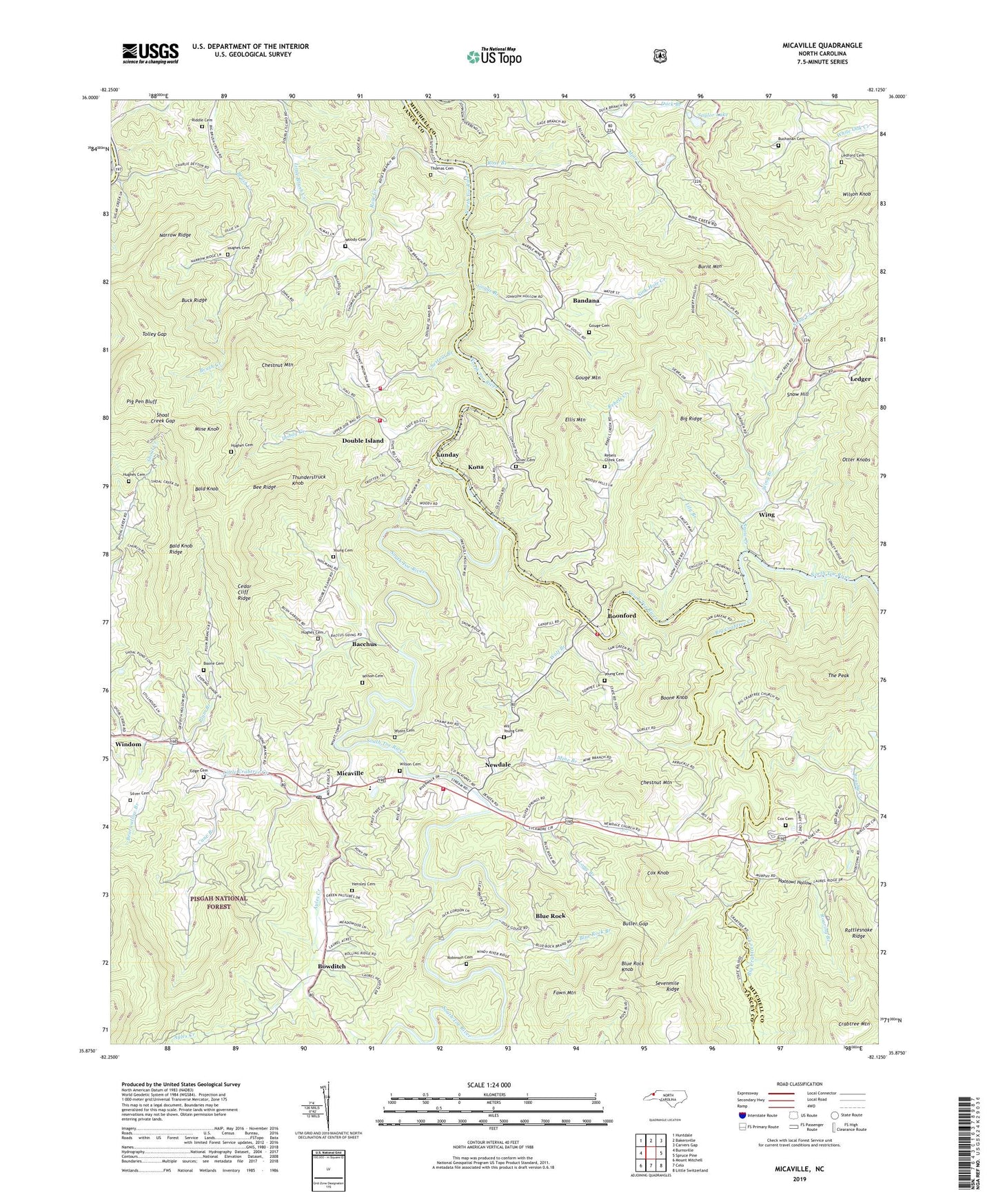
2019 topographic map quadrangle Micaville in the state of North Carolina. Scale: 1:24000. Based on the newly updated USGS 7.5' US Topo map series, this map is in the following counties: Yancey, Mitchell. The map contains contour data, water features, and other items you are used to seeing on USGS maps, but also has updated roads and other features. This is the next generation of topographic maps. Printed on high-quality waterproof paper with UV fade-resistant inks.
Quads adjacent to this one:
West: Burnsville
Northwest: Huntdale
North: Bakersville
Northeast: Carvers Gap
East: Spruce Pine
Southeast: Little Switzerland
South: Celo
Southwest: Mount Mitchell
Contains the following named places: Ayles Creek, Bacchus, Bald Knob, Bald Knob Ridge, Bandana, Bearwallow Branch, Bee Ridge, Big Crabtree Church, Big Crabtree Creek, Big Ridge, Blue Rock, Blue Rock Branch, Blue Rock Knob, Boone Cemetery, Boone Knob, Boonford, Bowditch, Brushy Creek, Buchanan Cemetery, Buck Ridge, Burnt Mountain, Butler Gap, Cane Branch, Cedar Cliff Ridge, Chestnut Branch, Chestnut Mountain, Clay Mound Church, Covy Rock Church, Cox Cemetery, Cox Knob, Crabtree Chapel, Crabtree Church, Crabtree Mountain, Deneen Dam, Deneen Reservoir, Dobag Creek, Double Island, Double Island Baptist Church, Double Island Fire Department, Double Island Volunteer Fire Department Station 2, Duck Branch, Edge Cemetery, Ellis Mountain, Fawn Mountain, Gouge Branch, Gouge Cemetery, Gouge Mountain, Gouge Primary Elementary, Hensley Cemetery, Hootowl Hollow, Hootowl Mine, Hughes Cemetery, Kona, Kona Church, Ledford Cemetery, Ledger, Liberty Hill Church, Lily Branch, Lily Branch Church, Little Crabtree Creek, Long Branch, Lunday, Martin Chapel, Micaville, Micaville Elementary School, Micaville Post Office, Mine Branch, Mine Creek Church, Mine Knob, Narrow Ridge, Newdale, Newdale Church, Newdale Volunteer Fire Department, Otter Knobs, Pig Pen Bluff, Pilgrim Chapel, Pleasant Gap Church, Pleasant Grove Church, Plum Branch, Plum Branch Church, Rattlesnake Ridge, Rebels Creek, Rebels Creek Cemetery, Rebels Creek Church, Riddle Cemetery, Roaring Branch, Robinson Cemetery, Rose Branch, Rose Creek, Saylor Lake, Shoal Creek, Shoal Creek Church, Shoal Creek Gap, Silver Cemetery, Silver Chapel, Sink Hole Creek, Sink Hole Mine, Snow Creek, Snow Hill, Snow Hill Church, South Toe River, South Toe Volunteer Fire and Rescue Station 2, The Peak, Thomas Cemetery, Thunderstruck Knob, Tolley Gap, Township of Brush Creek, Township of Crabtree, Township of Snow Creek, White Oak Church, Will Young Cemetery, Wilson Cemetery, Wilson Knob, Wing, Wing Branch, Wolf Branch, Woody Cemetery, Wyatt Cemetery, Young Cemetery, Young Chapel