MyTopo
Peachtree North Carolina US Topo Map
Couldn't load pickup availability
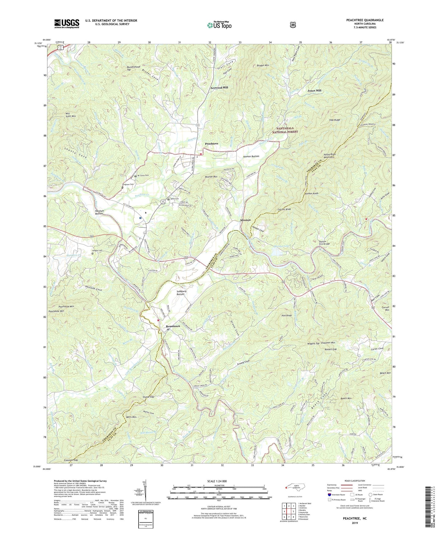
2019 topographic map quadrangle Peachtree in the state of North Carolina. Scale: 1:24000. Based on the newly updated USGS 7.5' US Topo map series, this map is in the following counties: Cherokee, Clay. The map contains contour data, water features, and other items you are used to seeing on USGS maps, but also has updated roads and other features. This is the next generation of topographic maps. Printed on high-quality waterproof paper with UV fade-resistant inks.
Quads adjacent to this one:
West: Murphy
Northwest: McDaniel Bald
North: Marble
Northeast: Andrews
East: Hayesville
Southeast: Hiawassee
South: Blairsville
Southwest: Nottely Dam
Contains the following named places: Ammon Bottom, Ammon Knob, Anderson Branch, Arrwood Mill, Auberry Branch, Beach Cove, Beach Creek, Beach Mountain, Bethesda Church, Betty Branch, Bevins Branch, Braden Mountain, Brasstown, Brasstown Creek, Brasstown Post Office, Brasstown Volunteer Fire Department, Brendle Branch, Brooks Cove, Buchanan Branch, Burl Branch, Burnthouse Branch, Calhoun Branch, Campbell Folk School, Carrol Lake Dam, Carroll Branch, Carroll Knob, Carroll Lake, Carter Cove, Carver Branch, Chasteen Mountain, Clay County Fire and Rescue Station 3, Clayton Branch, Coldspring Branch, Coleman Gap, Copperhill Church, Cornwell Branch, Curtis Branch, Donaldson Branch, Dyer Cove, Elliott Branch, Erlanger Western Carolina Hospital, Fain Cove, Fall Branch, Fate Puett Cove, Ferguson Cemetery, Frankum Branch, Garringer Branch, George Martin Branch, Graham Branch, Greasy Cove, Greasy Creek, Green Cove, Gregory Branch, Haigler Cemetery, Harshaw Bottom, Harshaw Branch, Henson Cove, Hickory Stand Church, Jenkins Branch, Jenkins Church, John Mason Branch, Jones Mill, Julie Cove, Lamb Branch, Ledford Cove, Little Brasstown Church, Little Brasstown Creek, Long Branch, Maggie Chapel, Mc Comb Branch, Mc Guire Cemetery, Messer Branch, Mill Branch, Mission, Mission Branch, Mission Dam, Mission Lake, Mission Mountain, Mission Quarry, Moody Branch, Mumblehead Top, New Hope Church, Ogden, Ogden Church, Ogden School, Painter Branch, Panther Branch, Payne Branch, Peachtree, Peachtree Creek, Peachtree Elementary School, Peachtree Volunteer Fire Department, Penland Cove, Pinelog Creek, Pinhook Branch, Pipes Branch, Plot Knob, Poorhouse Mountain, Ricks Branch, Rocky Branch, Russell Gap, Seibold Branch, Shallow Ford Bridge, Shanty Cove, Slow Creek, Snead Branch, Stamey Branch, Stump Gap, Suddawig Bottom, Suddawig Branch, Sudderth Branch, Sweetwater Church, Sweetwater Creek, Sweetwater School, Tibb Ridge, Township of Brasstown, Township of Sweetwater, Trout Cove, Trout Cove Branch, Truett Branch, Trull Cove, Tweed Branch, Upper Peachtree, Upper Peachtree Church, Walnut Cove, Watson Branch, WCVP-AM (Murphy), Wells Cemetery, Wells Mountain, Wesley Martin Branch, Wiggins Top, Will Mason Branch, Will Scott Mountain, ZIP Codes: 28902, 28909