MyTopo
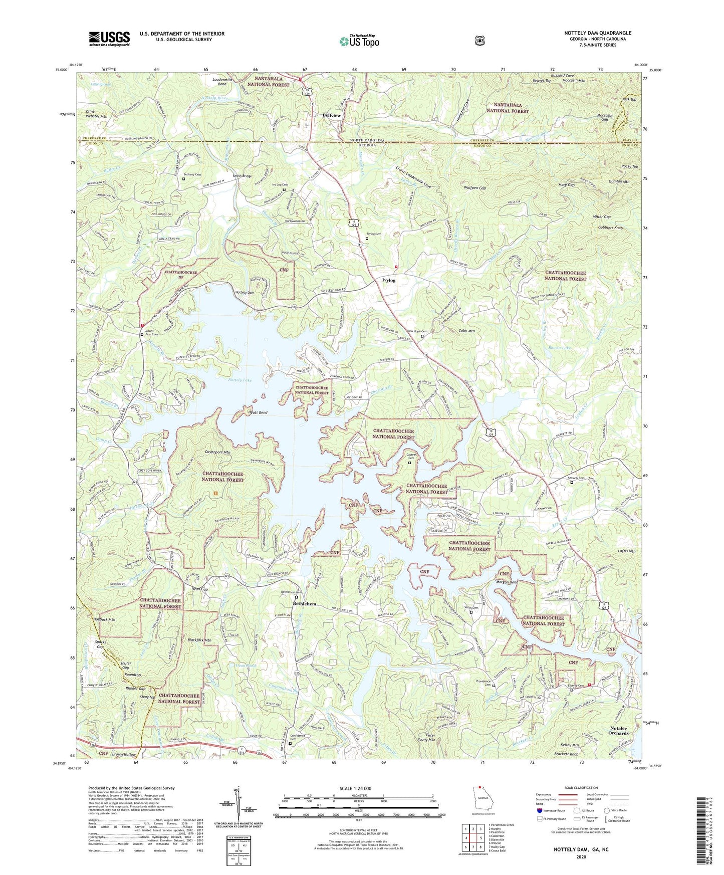
Nottely Dam Georgia US Topo Map
Couldn't load pickup availability
Also explore the Nottely Dam Forest Service Topo of this same quad for updated USFS data
2024 topographic map quadrangle Nottely Dam in the states of Georgia, North Carolina. Scale: 1:24000. Based on the newly updated USGS 7.5' US Topo map series, this map is in the following counties: Union, Cherokee, Fannin, Clay. The map contains contour data, water features, and other items you are used to seeing on USGS maps, but also has updated roads and other features. This is the next generation of topographic maps. Printed on high-quality waterproof paper with UV fade-resistant inks.
Quads adjacent to this one:
West: Culberson
Northwest: Persimmon Creek
North: Murphy
Northeast: Peachtree
East: Blairsville
Southeast: Coosa Bald
South: Mulky Gap
Southwest: Wilscot
Contains the following named places: Antioch Cemetery, Antioch Church, Antioch School, Barnes Creek, Beaver Top, Bellview, Bellview Volunteer Fire Department, Belview Community Center, Bethany Cemetery, Bethany Church, Bethany School, Bethlehem, Bethlehem Cemetery, Bethlehem Church, Bethlehem School, Blackjack Mountain, Bowen Lake, Bowen Lake Dam, Brackett Creek, Brown Hollow, Butler Creek, Camp Creek, Canal Lake Bible Camp, Casteel Branch, Casteel Cemetery, Chapman Ford, Charlie Brown Branch, Chastain Branch, Chastain Bridge, Cicero Loudermilk Cove, Clink Webster Mountain, Cobb Creek, Cobb Mountain, Collins Branch, Confidence Cemetery, Confidence Church, Confidence School, Conley Branch, Conley Creek, Cook Mill, Cunningham Branch, Davenport Mountain, Dean Gap, Dean Pond, Dooley Creek, Gobblers Knob, Gumlog Mountain, Hampton Cove, Hitchcock Branch, House of Prayer Church, Hyatt Bend, Ivy Log Cemetery, Ivy Log School, Ivylog, Ivylog Cemetery, Ivylog Church, Ivylog Creek, Ivylog Division, Jack Creek, Jack Top, Kelley Branch, Kelley Mountain, Lance Branch, Ledford Branch, Liberty Cemetery, Liberty Church, Little Spring, Lloyds Drag Strip, Loftis Mountain, Loudermild Bend, Low Creek, Macedonia Church, Macedonia School, Mary Gap, McBee Ford, McClure Branch, Miller Gap, Moccasin Church, Moccasin Creek, Moccasin Gap, Moccasin Mountain, Morgan Bend, Morgan Ford, Mount Zion Cemetery, Mount Zion Church, Mount Zion School, New Hope Cemetery, New Hope Church, New Hope School, Notalee Orchards, Nottely Dam, Nottely Dock, Nottely Lake, Odom Creek, Peter Young Mountain, Poteete Branch, Providence Cemetery, Providence Church, Providence School, Reece Creek, Rhodes Branch, Rhodes Gap, Rocky Top, Rogers Branch, Roundtop, Sharptop, Shuler Gap, Smith Bridge, Sparks Gap, Stephens Branch, Stillhouse Branch, Tate Mill, Tate School, Thomas Branch, Thomas Chapel, Thomas Chapel School, Thompson Bridge, Union County Fire Department Station 4, Union County Fire Department Station 6, Union County Fire Department Station 7, Union School, Wash Branch, Willis Cemetery, Wolfpen Gap, Yates Mill, Youngcane Creek