MyTopo
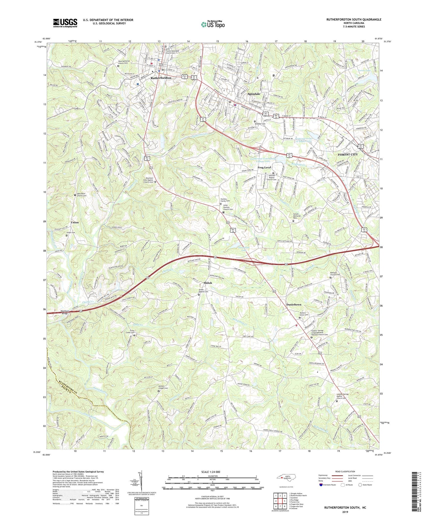
Rutherfordton South North Carolina US Topo Map
Couldn't load pickup availability
2019 topographic map quadrangle Rutherfordton South in the state of North Carolina. Scale: 1:24000. Based on the newly updated USGS 7.5' US Topo map series, this map is in the following counties: Rutherford, Polk. The map contains contour data, water features, and other items you are used to seeing on USGS maps, but also has updated roads and other features. This is the next generation of topographic maps. Printed on high-quality waterproof paper with UV fade-resistant inks.
Quads adjacent to this one:
West: Pea Ridge
Northwest: Shingle Hollow
North: Rutherfordton North
Northeast: Sunshine
East: Forest City
Southwest: Fingerville West
Contains the following named places: Adaville Baptist Church Cemetery, Adaville Church, Bakersville, Bethany Church, Bethany Church Cemetery, Callison Recreation Center, Carver Elementary School, Charles Creek, Cleghorn Country Club, Cleghorn Creek, Crestview Church, Danieltown, Dunbar Elementary School, Ellington Heights, Father's Vineyard, Forest City Municipal Golf Course, Forest Hills, Forest Lake, Forest Lake Dam, Fraternal Order Eagles Dam, Fraternal Order of Eagles Lake, Frog Level, Grays Creek, Grays Creek Cemetery, Grays Creek Church, Green River, Green Street Baptist Church, Holly Springs, Holly Springs Church, Huntley Church, Huntley Family Cemetery, Ingles Shopping Center, Isothermal College Dam, Isothermal Community College, Isothermal Community College Lake, Kistlers Chapel, Kistlers Chapel Cemetery, Little Huntley Church Cemetery, Long Branch, Means Chapel, Morning Star Church, Mountain Creek, Mountain View Baptist Church Cemetery, Mountain View Church, NC Noname One-Hundred Twenty-Seven Dam, New Hope Elementary School, North Carolina State Highway Patrol Troop G District 2 Substation, Oakland Elementary School, Oakland Heights, Oakland Plaza, Old Zion Church, Piedmont Church, Pinecrest, Poors Ford Church, Roots Store, Rutherford Correctional Center, Rutherford County Courthouse, Rutherford County Emergency Medical Services, Rutherford County Farm, Rutherford County Sheriff's Office, Rutherford Regional Medical Center, Rutherfordton, Rutherfordton Elementary School, Rutherfordton Fire Department, Rutherfordton Golf and Country Club, Rutherfordton Police Department, Rutherfordton Post Office, Rutherfordton-Spindale High School, Saint Francis Episcopal Church, Saint Francis Episcopal Church Cemetery, Saint Gabriels Church, Saint Paul Church, Shiloh, Shiloh Baptist Cemetery, Shiloh Baptist Church, Shiloh Danieltown Oakland Volunteer Fire Department, Shiloh Elementary School, Spindale, Spindale Cemetery, Spindale Elementary School, Spindale Fire Department, Spindale Police Department, Spindale Post Office, Stonecutter Creek, Stonecutter Mill, Sulphur Spring Church, Sulphur Springs Baptist Church Cemetery, Sulphur Springs Church, Sulphur Springs Congregational Holiness Church Cemetery, Sunnyside Lake, Sunnyside Lake Dam, Sunset Memorial Park, Tanners Grove Cemetery, Tanners Grove Church, Town of Rutherfordton, Town of Spindale, Township of Rutherfordton, Township of Union, Tri-City Mall, Trinity Lutheran Church, Union, Union Cemetery, Union Church, WAGY-AM (Forest City), Washburn Bridge, Washburns Mill, WBBO-AM (Forest City), WBBO-FM (Forest City), Weatherstone, West Memorial Church, West Memorial Church Cemetery, West Point Church, West Point Church Cemetery, WGMA-AM (Spindale), White Oak Creek, Wilkins School, ZIP Codes: 28139, 28160