MyTopo
Southeast Durham North Carolina US Topo Map
Couldn't load pickup availability
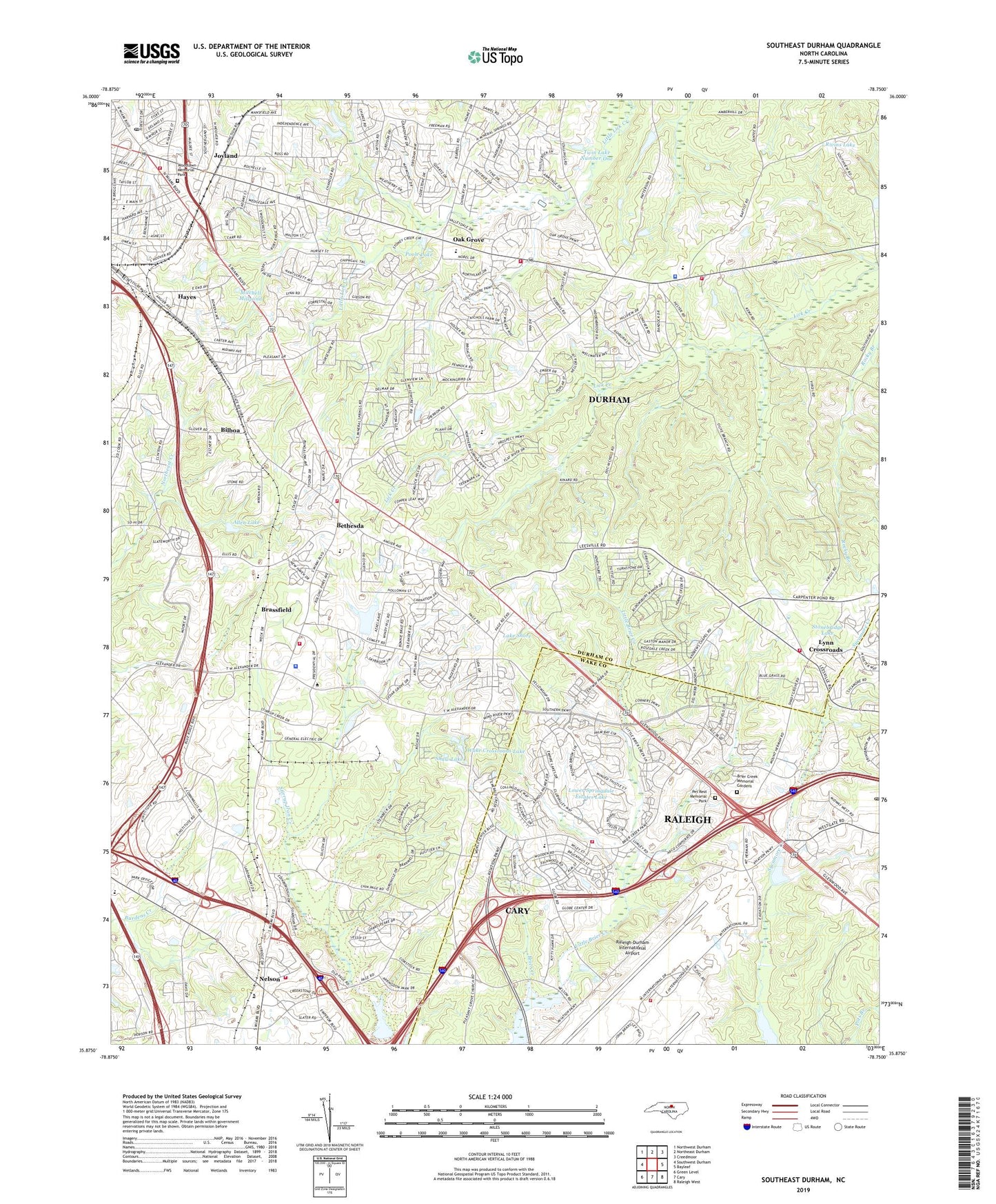
2019 topographic map quadrangle Southeast Durham in the state of North Carolina. Scale: 1:24000. Based on the newly updated USGS 7.5' US Topo map series, this map is in the following counties: Durham, Wake. The map contains contour data, water features, and other items you are used to seeing on USGS maps, but also has updated roads and other features. This is the next generation of topographic maps. Printed on high-quality waterproof paper with UV fade-resistant inks.
Quads adjacent to this one:
West: Southwest Durham
Northwest: Northwest Durham
North: Northeast Durham
Northeast: Creedmoor
East: Bayleaf
Southeast: Raleigh West
South: Cary
Southwest: Green Level
Contains the following named places: Adams Crossroads, Allen Lake, Allen Lake Dam, Andrews Chapel, Angus Barn Pond Dam, Anointed Word Ministries, Bailey Lake Dam, Believers Assembly Christian Church, Bethesda, Bethesda Baptist Church at the Park, Bethesda Baptist Church Mission House, Bethesda Elementary School, Bethesda Volunteer Fire Company Station 2, Bethesda Volunteer Fire Department Station 1, Bilboa, Brassfield, Brier Creek Memorial Gardens, Calvary Church, Chandler Lake Dam, Church of God and True Holiness, Church on the Rock, Crabtree Creek W/S, Crabtree Creek W/S Structure Number One Dam, Durham County Emergency Medical Services Station 4, Durham County Sheriff's Office - East Station, Durham Fire Department Station 13, Durham Fire Department Station 3, Durham Fire Department Station 8, Durham Memorial Baptist Church, Durham Mennonite Church, Durham Police Department District 4 Substation, East Durham Post Office, Evangelical Assembly of God, Evergreen Community Church, First Freewill Baptist Church, Full Gospel Holy Church, Fuller Memorial Associate Reformed Presbyterian Church, General Electric Number Two Dam, God's House of Refuge, Gospel Church, Greater Emmanuel Family Life Enrichment Center, Greater Emmanuel Pentecostal Temple, Greater New Birth Baptist Church, Hayes, Henderson Church, Highway House of Prayer, Holy Transfiguration Orthodox Church, Immanuel Church, Joyland, Kings Pond, Kings Pond Dam, Lake Shore, Lake Shore Dam, Little Brier Creek, Living Waters Christian Community, Loving Heart Christian Center, Lower Springdale Estates Lake, Lynn Crossroads, Martin Branch, Mitchell Millpond, Mount Herman Church, Neal Middle School, Nelson, New Jerusalem Free Will Baptist Church, New Trinity Church, North Carolina State Highway Patrol Troop C District 7, Oak Grove, Oak Grove Elementary School, Old Fashioned Tabernacle, Olive Branch Church, Orange Grove Church, Orange Grove Missionary Baptist Church, Parkwood Volunteer Fire Department Station 3, Perry Pond, Pet Rest Memorial Park, Pleasant Grove Church, Poole Lake, Raleigh - Durham International Airport Emergency Services, Raleigh Fire Department Station 24, Raleigh-Durham International Airport, Redwood Volunteer Fire Department Station 3, Research Triangle Park, River of Joy Worship Center, Rivins Lake, Robbins Road Christian Church, Roger Grove Church, Saint Andrew United Methodist Church, Shady Grove Church, Sharon Acres Church, Shaw Lake, Sherron Acres Free Will Baptist Church, Smith Chapel, Southern High School, Spring Valley Elementary, Stonebridge Lake, The Church of God of Prophecy, Township of Carr, Triangle Church, Trinity Baptist Church, Twin Lake Number One, Twin Lake Number One Dam, Twin Lake Number Two Dam, United For Christ Church Day Care Center, United For Christ Outreach Center, Westgate Post Office, Woodlawn Memorial Park, Y E Smith Elementary Museum School, ZIP Codes: 27617, 27703, 27709