MyTopo
Weddington North Carolina US Topo Map
Couldn't load pickup availability
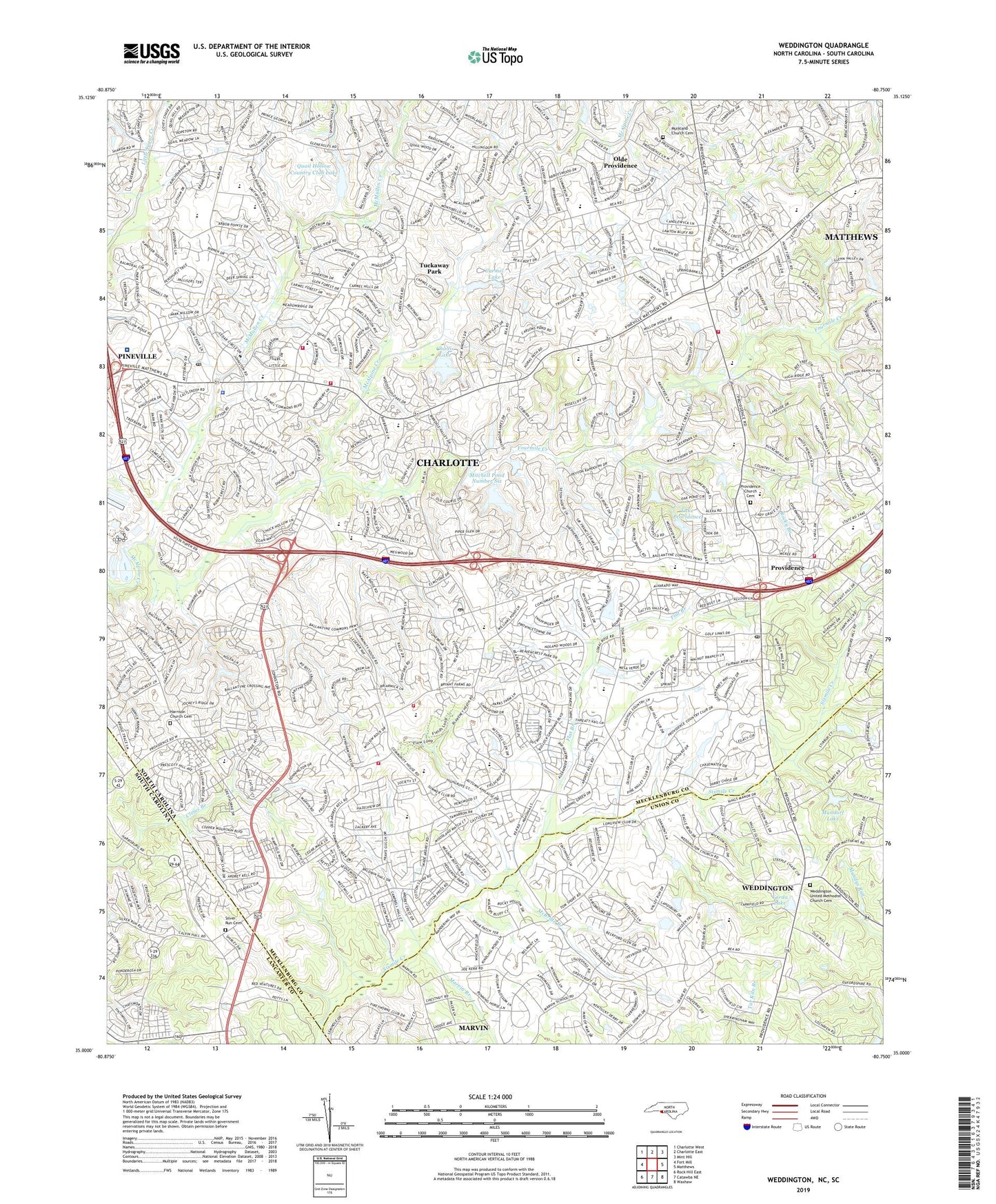
2022 topographic map quadrangle Weddington in the states of North Carolina, South Carolina. Scale: 1:24000. Based on the newly updated USGS 7.5' US Topo map series, this map is in the following counties: Mecklenburg, Union, Lancaster. The map contains contour data, water features, and other items you are used to seeing on USGS maps, but also has updated roads and other features. This is the next generation of topographic maps. Printed on high-quality waterproof paper with UV fade-resistant inks.
Quads adjacent to this one:
West: Fort Mill
Northwest: Charlotte West
North: Charlotte East
Northeast: Mint Hill
East: Matthews
Southeast: Waxhaw
South: Catawba NE
Southwest: Rock Hill East
Contains the following named places: Ballantyne Post Office, Cady Lake, Cady Lake Dam, Carmel, Carmel Academy, Carmel Commons, Carmel Commons Shopping Center, Carmel Country Club, Carmel Lake, Carmel Lake Dam, Carmel Road New Post Office, Carolina Volunteer Fire Department Station 1, Carolina Volunteer Fire Department Station 2, Carolinas HealthCare System Pineville, Cedarwood Golf Club, Challis Lake, Challis Lake Dam, Charlotte - Mecklenburg Police Department South Division, Charlotte Fashion Plaza, Charlotte Fire Department Station 24, Charlotte Fire Department Station 32, Charlotte Fire Department Station 39, Charlotte Fire Department Station 9, Charlotte Latin School, Clems Branch, Colonial Village, Dr Jay M Robinson Middle School, Elrod Pond, Elrod Pond Dam, Falcon Bridge, Flat Branch, Fourmile Creek, Harrison, Harrison Church, Harrison Church Cemetery, Hawk Ridge Elementary School, Highway 51 Senior High School, Jonesville Zion Church, Kingswood, Lake Providence, Lake Windermere, Marvin Branch, McAlpine Elementary School, McBride Branch, McKee Road Elementary School, McMullen Creek, McMullen Creek Market, Mercy Hospital Medical Park, Mitchell Dam Number Six, Mitchell Pond Number Six, Mundorf Lake, Mundorf Lake Dam, Murkland Church, Murkland Church Cemetery, Old Town Shopping Center, Olde Providence, Olde Providence Elementary School, Pineville Church, Pleasant Hill Church, Pleasant Valley, Pleasant Valley School, Providence, Providence Church, Providence Church Cemetery, Providence Plantation, Providence Senior High School, Providence West, Public Library of Charlotte and Mecklenburg County - Carmel Branch, Public Library of Charlotte and Mecklenburg County - South County Regional Branch, Quail Corners Shopping Center, Quail Hollow, Quail Hollow Country Club, Quail Hollow Country Club Lake, Quail Hollow Country Club Lake Dam, Quail Hollow Middle School, Raintree, Reid Lake, Reid Lake Dam Number Two, Reid Lake Number One Dam, Reid Lake Number Two, Rocky Branch, Settlers Landing, Silver Run Cemetery, Silver Run Church, Smithfield Church, Smithfield Elementary School, South Charlotte Middle School, South Mecklenburg High School, South Providence Post Office, Tower Place Festival Shopping Center, Township 4 Sharon, Tuckaway Park, Varda Lake, Village of Marvin, Weddington, Weddington United Methodist Church Cemetery, Windermere Lake Dam, Wren Creek, ZIP Codes: 28226, 28270, 28277