MyTopo
Yadkinville North Carolina US Topo Map
Couldn't load pickup availability
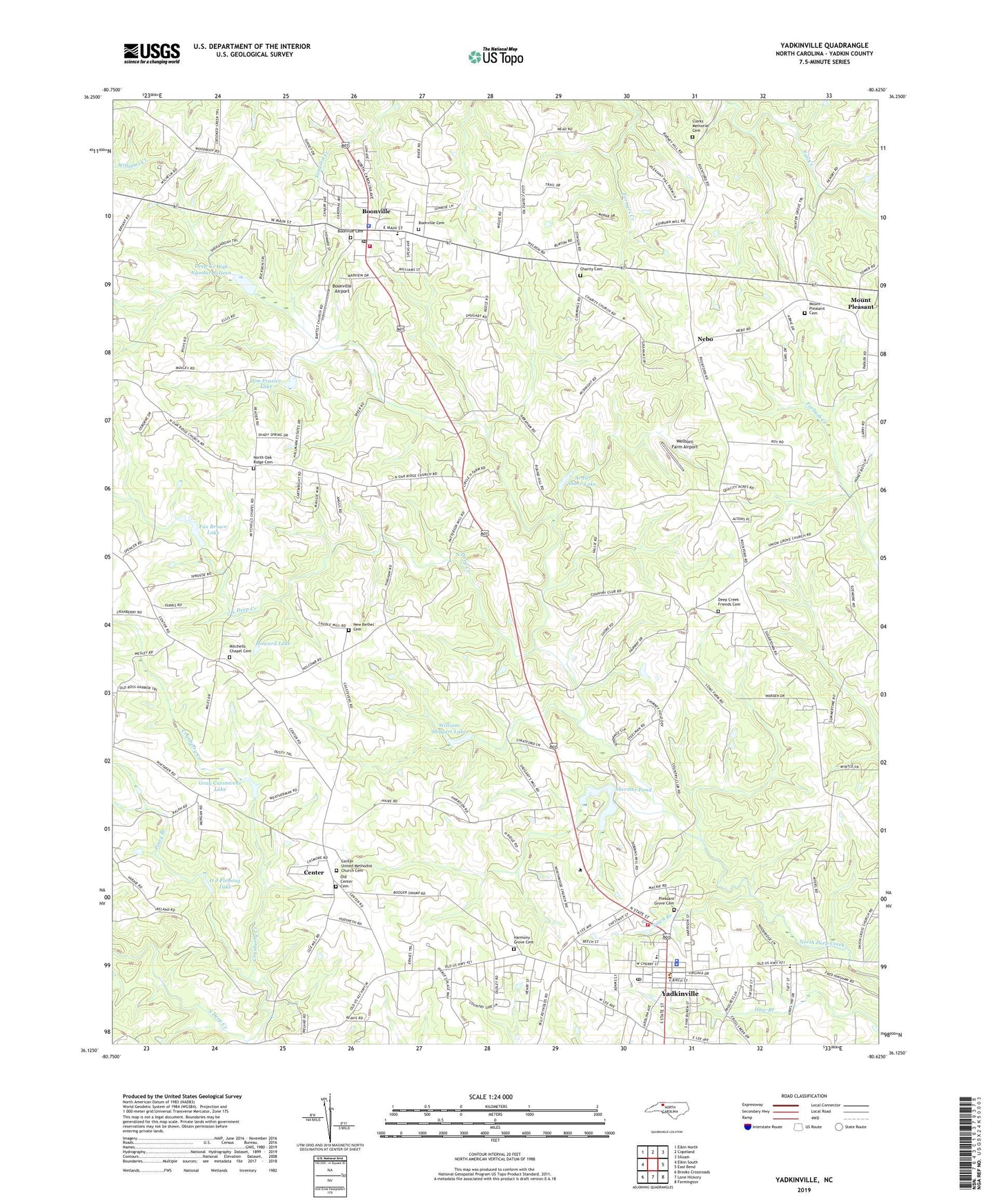
2019 topographic map quadrangle Yadkinville in the state of North Carolina. Scale: 1:24000. Based on the newly updated USGS 7.5' US Topo map series, this map is in the following counties: Yadkin. The map contains contour data, water features, and other items you are used to seeing on USGS maps, but also has updated roads and other features. This is the next generation of topographic maps. Printed on high-quality waterproof paper with UV fade-resistant inks.
Quads adjacent to this one:
West: Elkin South
Northwest: Elkin North
North: Copeland
Northeast: Siloam
East: East Bend
Southeast: Farmington
South: Lone Hickory
Southwest: Brooks Crossroads
Contains the following named places: Arnie Shore Lake, Arnie Shore Lake Dam, Boonville, Boonville Airport, Boonville Baptist Church, Boonville Cemetery, Boonville Elementary School, Boonville First Presbyterian Church, Boonville Police Department, Boonville Post Office, Boonville United Methodist Church, Boonville Volunteer Fire Department, Caudle Mill, Center, Center United Methodist Church, Center United Methodist Church Cemetery, Charity Baptist Church, Charity Cemetery, Clarks Memorial Cemetery, Clarks Memorial Church, Cranberry Creek, Cranberry School, Deep Creek Friends Cemetery, Deep Creek Friends Church, Deep Creek W/S Number Sixteen, Dobbins Pond, Farmers Creek, Fax Brown Lake, Fax Brown Lake Dam, Frank Poindexter Dam, George Penergrass Lake, George Penergrass Lake Dam, Gray Casstevens Lake, Gray Casstevens Lake Dam, Harmony Grove Cemetery, Harmony Grove Friends Church, Howard Lake, Howard Lake Dam, Jim Frazier Lake, Jim Frazier Lake Dam, Johnson School, Mason Mill, Mitchell's Chapel United Methodist Church, Mitchell's Chapel United Methodist Church Cemetery, Mount Nebo Holy Church, Mount Pleasant, Mount Pleasant Cemetery, Mount Pleasant United Methodist Church, Nebo, New Bethel Cemetery, New Bethel Pentecostal Holiness Church, North Oak Ridge Baptist Church, North Oak Ridge Cemetery, O J Fleming Lake, O J Fleming Lake Dam, Old Center Cemetery, Piney Branch, Pleasant Grove Baptist Church, Pleasant Grove Cemetery, Randolph School, Reece School, Shermer Pond, Shermer Pond Dam, Shuggarts Mill, Southside Church, Speas Mill, Town Branch, Town of Boonville, Town of Yadkinville, Township of Boonville, Township of North Liberty, Twiman Candle Lake, Twiman Candle Lake Dam, Union Hill Church, Welborn Farm Airport, William Shugart Lake, William Shugart Lake Dam, WYDK-AM (Yadkinville), Yadkin County, Yadkin County Developmental Resource Center, Yadkin County Emergency Medical Services, Yadkin County Rescue Squad, Yadkin County Sheriff's Office, Yadkin Valley Memorial Hospital, Yadkinville, Yadkinville Country Club, Yadkinville Elementary School, Yadkinville Police Department, Yadkinville Post Office, Yadkinville Volunteer Fire Department, ZIP Code: 27011