MyTopo
Hilliard Ohio US Topo Map
Couldn't load pickup availability
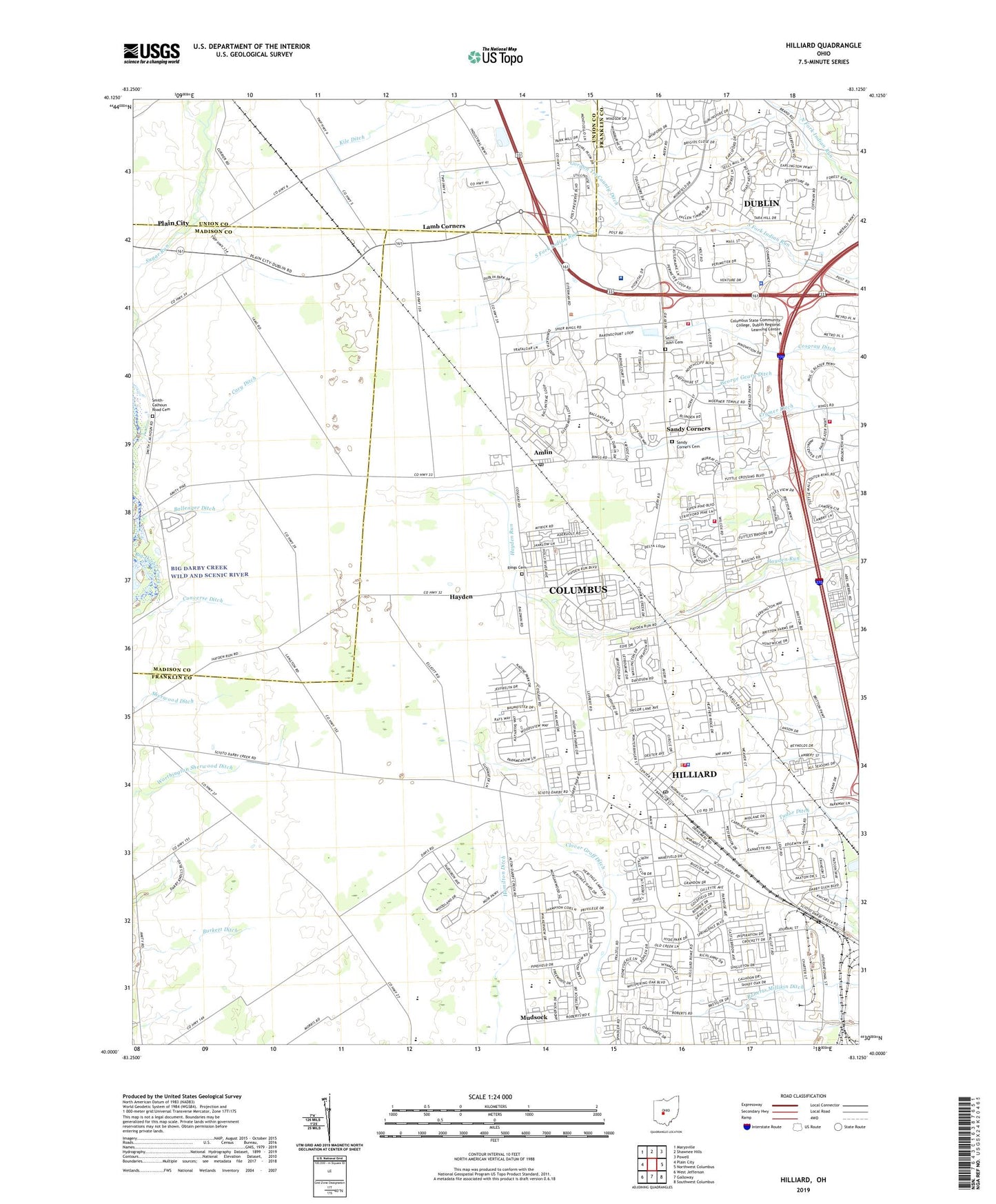
2023 topographic map quadrangle Hilliard in the state of Ohio. Scale: 1:24000. Based on the newly updated USGS 7.5' US Topo map series, this map is in the following counties: Franklin, Madison, Union. The map contains contour data, water features, and other items you are used to seeing on USGS maps, but also has updated roads and other features. This is the next generation of topographic maps. Printed on high-quality waterproof paper with UV fade-resistant inks.
Quads adjacent to this one:
West: Plain City
Northwest: Marysville
North: Shawnee Hills
Northeast: Powell
East: Northwest Columbus
Southeast: Southwest Columbus
South: Galloway
Southwest: West Jefferson
This map covers the same area as the classic USGS quad with code o40083a2.
Contains the following named places: Abbey Chase, Amlin, Amlin Post Office, Anderson Meadows, Ashleigh Village, Avery Elementary School, Avery Estates, Avery Park, Avery Square Shopping Center, Ballenger Ditch, Bayberry Creek, Beacon Elementary School, Brittany Oaks, Britton Elementary School, Britton Farms, Brookbend, Brookfield, Brown Elementary School, Burkett Ditch, Carriage Run, Carrington Place, Cary Ditch, City of Dublin, City of Hilliard, Clover Groff Ditch, Coffman Park, Columbus Division of Fire Station 34, Colwell Church, Converse Ditch, Copperwood, Corporate Park of Dublin, Cosgray Ditch, Coventry Manor, Cramer Ditch, Cross Creek, Darby Glen, Dorset Glen, Dublin City Hall, Dublin High School, Dublin Industrial Park, Dublin Methodist Hospital, Dublin Police Department, Dublin Post Office, Dublin Technical Center, Dublin Technical Mart, Estates At Hoffman Farms, Fishel Industrial Park, Franklin County Fairgrounds, George Geary Ditch, Gordon Tri-County Ditch, Hamilton Park, Hampton Oaks, Hampton Reserve, Haven Fellowship Cemetery, Hayden, Hayden Post Office, Hayden Run Village, Heather Ridge, Heritage Creek, Heritage Farms, Heritage Lakes, Hiliard Elementary School, Hilliard, Hilliard Church of Christ, Hilliard City Hall, Hilliard Corporate Center, Hilliard Freewill Baptist Church, Hilliard Heights, Hilliard High School, Hilliard Industrial Park, Hilliard Middle School, Hilliard Mill Run Nazarene Church, Hilliard Municipal Park, Hilliard Police Department, Hilliard Post Office, Hilliard Presbyterian Church, Hilliard Run, Hilliard Square Shopping Center, Hilliard United Methodist Church, Hoffman Farms, Hyde Park, J W Reason Elementary School, Jerome Industrial Park, Kile Ditch, Kileville, Kileville Post Office, Lakewood, Lamb Corners, Luxair, Mall At Tuttle Crossing Shopping Center, Miami Valley Heliport, Mudsock, Norwich Township Fire Department Station 81, Oak Run, Parknavy Airport, Perimeter Shopping Center, Red Roof Inns Heliport, Richlanne Acres, Rings Cemetery, Ritters Airport, Saint John Cemetery, Saint Johns Church, Sandy Corners, Sandy Corners Cemetery, Scioto Industrial Park, Sherwood Ditch, Silver Springs, Stouffers Dublin Heliport, The Suburbans Mobile Home Park, Township of Brown, Township of Norwich, Township of Washington, Tudor Ditch, Washington Township Fire Department and Emergency Medical Services Station 95, Washington Township Fire Department Station 91, Westbriar, Westbrooke Park, Western Lakes, Westwind, Worthington Sherwood Ditch, ZIP Codes: 43002, 43016, 43017, 43026