MyTopo
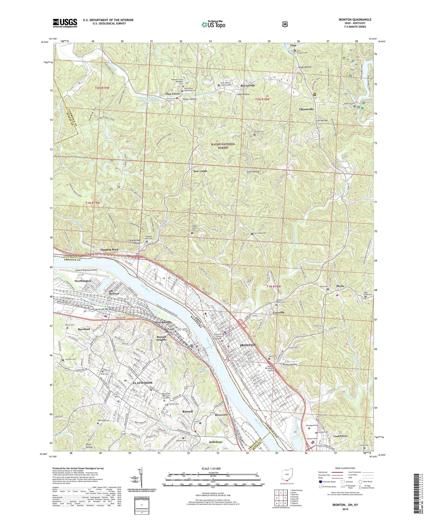
Ironton Ohio US Topo Map
Couldn't load pickup availability
Also explore the Ironton Forest Service Topo of this same quad for updated USFS data
2023 topographic map quadrangle Ironton in the states of Ohio, Kentucky. Scale: 1:24000. Based on the newly updated USGS 7.5' US Topo map series, this map is in the following counties: Lawrence, Greenup, Scioto, Boyd. The map contains contour data, water features, and other items you are used to seeing on USGS maps, but also has updated roads and other features. This is the next generation of topographic maps. Printed on high-quality waterproof paper with UV fade-resistant inks.
Quads adjacent to this one:
West: Greenup
Northwest: Wheelersburg
North: Pedro
Northeast: Sherritts
East: Kitts Hill
Southeast: Catlettsburg
South: Ashland
Southwest: Argillite
This map covers the same area as the classic USGS quad with code o38082e6.
Contains the following named places: Advance School, Amanda Furnace Historical Marker, Apostolic Church, Apostolic Gospel Church, Ashland Regional Airport, Baldridge Cemetery, Bear Run, Beechwood Park, Bellefonte Memorial Gardens, Bide-A-Wee, Briggs-Lawrence County Public Library, Calvary Baptist Church, Calvary Cemetery, Campbell Chapel, Campbell Elementary School, Caroline Cemetery, Cecil Hollow, Central Christian Church, Central High School, Christ Episcopal Church, Church of Christ, City of Flatwoods, City of Ironton, City of Raceland, City of Russell, City of Worthington, Coal Grove, Coal Grove Fire Department, Coalgrove Post Office, Continuous Steel Sheet Rolling Historical Marker, Coryville, Coryville School, Davidson Landing, Dawson-Bryant High School, Dawson-Bryant Intermediate School, Edgemont School, Elizabeth Township Volunteer Fire Department Station 2, Ellison Street Church of the Nazarene, Ellisonville, Elm Street Church of the Nazarene, Etna, Etna Furnace Cemetery, Fifth and Lawrence Streets Residential Historic District, First Baptist Church of Ironton, First Congregational Church, First Presbyterian Church, First Tabernacle Church, First United Methodist Church, Fisher Hollow, Flatwoods, Flatwoods Police Department, Flatwoods Post Office, Flatwoods Volunteer Fire Protection District, Flatwoods-Russell Division, Gateway Baptist Church, Greater Emmanuel Apostolic Faith Tabernacle, Green Valley, Greenup County Emergency Medical Services, Hanging Rock, Hanging Rock Cemetery, Hanging Rock Post Office, Hecla, Hecla Branch Storms Creek, Hecla Cemetery, Hecla Post Office, Hog Run, Ice Creek, Immanuel Church, Indian Run Church, Irish Hollow, Ironton, Ironton City Hall, Ironton Country Club, Ironton Fire Department, Ironton High School, Ironton Middle School, Ironton Police Department, Ironton Post Office, Ironton Sewage Treatment Plant, Ironton Water Filtration Plant, Islington Run, Kelly Cemetery, Kennedy Hollow, Kingsbury Elementary School, La Grange, La Grange Cemetery, LaGrange Church, Lake Vesuvius Dam, Lawrence County Bar and Law Library, Lawrence County Courthouse, Lawrence County Home, Lawrence County Museum, Lawrence County Sheriff's Office, Lawrence Street School, Little Ice Creek, Lombard School, Long Bridge Hollow, Loran Street Church, McCoy Cemetery, McDowell School, Meade Run, Melrose, Memorial Hall, Mount Olive Baptist Church, Nazarene Church, New Castle, Newton Cemetery, Norman Run, Norris Branch, Oak Ridge, Obryan Cemetery, Osborne Run, Our Lady of Bellefonte Hospital, Palmer Cemetery, Patriot Emergency Medical Services Ironton Station, Pigeon Hollow Cemetery, Pine Creek Structure Number Eight Dam, Pine Creek Structure Number Eight Reservoir, Pine Grove, Pine Grove Church, Pine Grove Methodist Cemetery, Pine Street United Methodist Church, Pleasant Grove Methodist Cemetery, Polecat Branch Hag Run, Quinn Chapel, Raceland, Raceland Police Department, Raceland Volunteer Fire Protection District, Rankin Historic District, Reorganized Church of Jesus Christ of Latter Day Saints, Richey Hollow, Riverview, Rock Hill High School, Rock Hill Number 3 Elementary School, Rock Hill Number 4 Elementary School, Royersville, Royersville Church, Rude Cemetery, Russell, Russell Fire Station 2, Russell Heights, Russell High School, Russell Police Department, Russell Post Office, Russell Volunteer Fire Protection District, Sacred Heart Cemetery, Saint Joseph Catholic Church, Saint Josephs High School, Saint Lawrence O'Toole Catholic Church, Saint Lawrence School, Saint Marys Catholic Cemetery, Saint Marys Church, Saint Paul Lutheran Church, Sharon Baptist Church, Shawnee Church, Short Hollow, Slope Hollow, Southeast Ohio Emergency Medical Services Station 11 Ironton, Storms Creek, Storms Creek Church, Sugar Creek Cemetery, Sugar Creek Church, Sydenstricker Church, Three Oaks, Toad Hollow, Township of Hamilton, Township of Upper, Triedstone Church, Tunnel Cemetery, Union Branch, Upper Township Volunteer Fire Department, Vesuvius, Vesuvius Cemetery, Vesuvius Furnace, Vesuvius Post Office, Vesuvius Recreation Area, Village of Hanging Rock, West Ironton Elementary School, West Russell, White Oak Creek, Whitwell Elementary School, WIRO-AM (Ironton), WMLV-FM (Ironton), Woodland Cemetery, Worthington, Worthington Police Department, Worthington Post Office, Worthington Volunteer Fire Protection District, WOUL-FM (Ironton), Yellow Branch, Zoar Cemetery, ZIP Codes: 41139, 41169, 41183, 45638