
MyTopo
Lansing Ohio US Topo Map
Couldn't load pickup availability
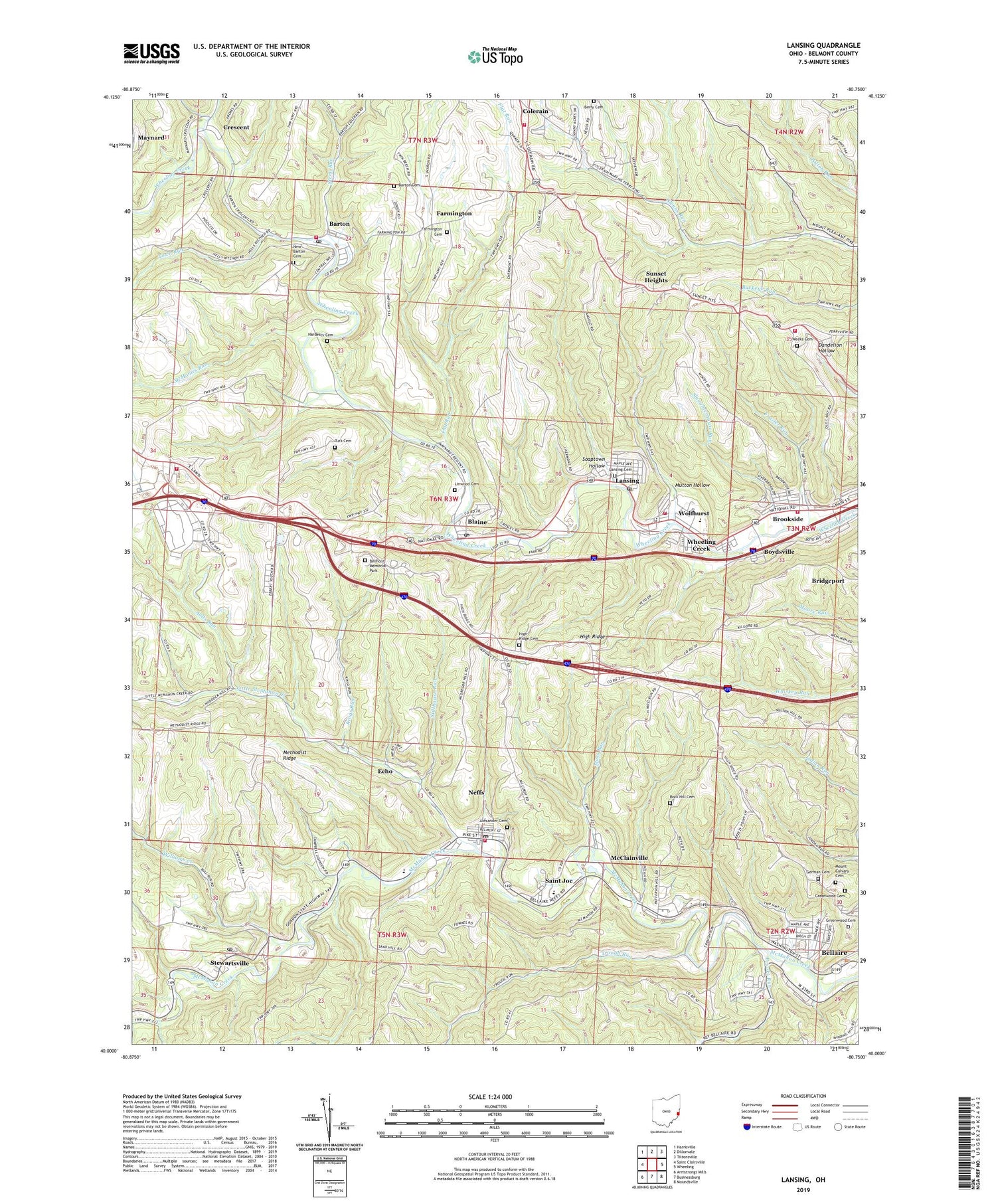
2019 topographic map quadrangle Lansing in the state of Ohio. Scale: 1:24000. Based on the newly updated USGS 7.5' US Topo map series, this map is in the following counties: Belmont. The map contains contour data, water features, and other items you are used to seeing on USGS maps, but also has updated roads and other features. This is the next generation of topographic maps. Printed on high-quality waterproof paper with UV fade-resistant inks.
Quads adjacent to this one:
West: Saint Clairsville
Northwest: Harrisville
North: Dillonvale
Northeast: Tiltonsville
East: Wheeling
Southeast: Moundsville
South: Businessburg
Southwest: Armstrongs Mills
Contains the following named places: Alexander Cemetery, Aults Run, Barton, Barton Cemetery, Barton Elementary School, Barton Post Office, Barton Volunteer Fire Department Station 13, Belmont County Fire Station 23 Cumberland Trail Fire and Emergency Medical Services Station 2, Belmont Memorial Park, Berry Cemetery, Blaine, Blaine Census Designated Place, Blaine Elementary School, Blaine Post Office, Boydsville, Brooks Run, Brooks Run Methodist Episcopal Church, Brookside, Brookside Fire Department, Brookside Public School, Church of God, Claremont, Coalbrook Presbyterian Church, Colerain Volunteer Fire Company, Crescent, Crescent Post Office, Echo, Fall Run, Farmington, Farmington Cemetery, Flat Run, Fox Run Center for Children and Adolescents, Frazier Run, German Cemetery, Greenwood Cemetery, Hardesty Cemetery, High Ridge, High Ridge Cemetery, Hills Plaza Shopping Center, Kings Run, Lancaster Chapel, Lansing, Lansing Cemetery, Lansing Census Designated Place, Lansing Post Office, Lansing Primary School, Linwood Cemetery, Little McMahon Creek, McClainville, McClainville Post Office, McMonies Run, Methodist Ridge, Moss Run, Mount Calvary Cemetery, Mutton Hollow, Neff Methodist Episcopal Church, Neff Public School, Neffs, Neffs Census Designated Place, Neffs Elementary School, Neffs Fire Department, Neffs Post Office, New Barton Cemetery, Ohio State Highway Patrol - Saint Clairsville Patrol Post, Ohio Valley Mall Shopping Center, Presidential Estates, Rock Hill Cemetery, Rock Hill Church, Sacred Heart Roman Catholic Church, Sacred Heart School, Saint Anthony of Padua Roman Catholic Church, Saint Anthony of Padua School, Saint Joe, Slaughterhouse Run, Soaptown Hollow, Steep Run, Steple Valley Elementary School, Stewartsville, Stewartsville Post Office, Stillhouse Run, Sunset Heights, Sunset Heights Volunteer Fire Department, Tar Run, Town Run, Township of Colerain, Township of Pease, Township of Pultney, Trough Run, Turk Cemetery, Village of Brookside, Weeks Cemetery, WEEL-FM (Shadyside), West Bellaire Elementary School, West Bridgeport Methodist Church, Westbrooke Intermediate School, Wheeling Creek, Williams Creek, Wolfhurst, Wolfhurst Census Designated Place, Wolfhurst Volunteer Fire Department Station 41, WOMP-AM (Bellaire), WOMP-FM (Bellaire), ZIP Codes: 43905, 43906, 43912, 43934, 43940


