MyTopo
Moundsville West Virginia US Topo Map
Couldn't load pickup availability
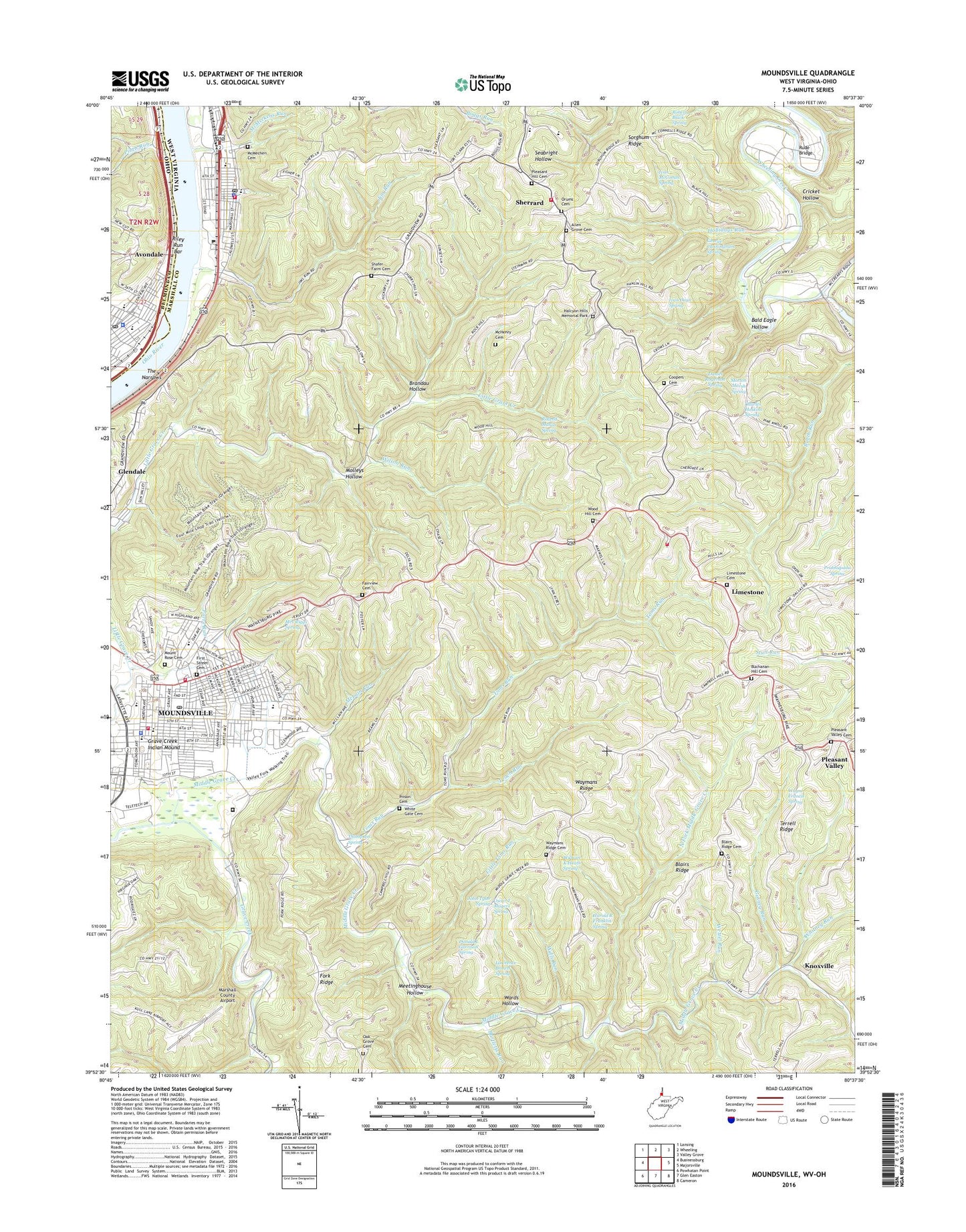
2023 topographic map quadrangle Moundsville in the states of West Virginia, Ohio. Scale: 1:24000. Based on the newly updated USGS 7.5' US Topo map series, this map is in the following counties: Marshall, Belmont. The map contains contour data, water features, and other items you are used to seeing on USGS maps, but also has updated roads and other features. This is the next generation of topographic maps. Printed on high-quality waterproof paper with UV fade-resistant inks.
Quads adjacent to this one:
West: Businessburg
Northwest: Lansing
North: Wheeling
Northeast: Valley Grove
East: Majorsville
Southeast: Cameron
South: Glen Easton
This map covers the same area as the classic USGS quad with code o39080h6.
Contains the following named places: Adena Hills Behavioral Health Center, All Saints Catholic School, Allen Grove Cemetery, Allen Grove Presbyterian Church, Allen School, Ash Avenue Church of God, Avondale, Bald Eagle Hollow, Bartletts Run, Benwood-McMechen Public Library, Bethel African Methodist Episcopal Church, Bishop Donahue High School, Blairs Ridge, Blairs Ridge Cemetery, Blairs Ridge Church, Blairs Ridge School, Brandau Hollow, Buchanan Hill Cemetery, Burches Run Wildlife Management Area, Calvary United Methodist Church, Camp Fairchance, Center McMechen Elementary School, Central Elementary School, Central School, Charity Independent Baptist Church, Charles Hoskins Spring, Chestnut Grove School, Church of Christ, Church of God, Church of God Seventh Day Adventist, Church of the Nazarene, Circle A School, City of McMechen, City of Moundsville, Coopers Cemetery, Cricket Hollow, Daniel Rogerson Spring, Delf Norona Museum, District 2, District School, Donald L Garrison Spring, East End Park, Fairview Cemetery, Fairview School, Fairview United Methodist Church, First Baptist Church, First Christian Church, First Church of God, First Street Cemetery, First United Presbyterian Church, First Ward School, Fork Ridge Community Building, Fort Tomlinson, Fort Van Metre, Fostoria Glass Museum, Gateway Achievement Center, George Cunningham Spring, Glendale Heights, Gosney Run, Grand Vue Park Golf Course, Grave Creek Indian Mound, Halcyon Hills Memorial Gardens, Harold R Franklin Spring, Hilltop Elementary School, Holiness Church, Hollidays Run, House of Prayer, Ivan Dean Spring, Ivan McCombs Spring, Jim Run, John Tyler Spring, Kingdom Hall of Jehovahs Witnesses, Kings School, Knoxville, Laurel Point School, Lawrence Brown Spring, Leach Run, Leona Avenue Middle School, Limestone, Limestone Cemetery, Limestone Church, Limestone Elementary School, Limestone Regional Emergency Service Incorporated, Limestone Volunteer Fire Department, Lincoln Avenue Methodist Episcopal Church, Little Toms Run, Lock and Dam Number 13, Marshall County Airport, Marshall County Animal Shelter, Marshall County Courthouse, Marshall County Fairgrounds, Marshall County Jail, Marshall County Senior Citizens Center, Marshall County Sheriff's Office, McConnell School, McHenry Cemetery, McLain Run, McMechen, McMechen Cemetery, McMechen City Hall, McMechen City Park and Pool, McMechen Police Department, McMechen Post Office, McMechen United Methodist Church, McMechen Volunteer Fire Department, McMeckens Run, McNinch Elementary School, Meetinghouse Hollow, Messiah Lutheran Church, Methodist Park, Middle Grave Creek, Middle Grave Creek Church of the Brethren, Miracle Valley Regional Library System Headquarters, Molleys Hollow, Morton Marsh Spring, Moundsville, Moundsville Baptist Church, Moundsville Christian Assembly of God Church, Moundsville Christian School, Moundsville City Church of Christ, Moundsville Fire Department, Moundsville Middle School, Moundsville Police Department, Moundsville Post Office, Moundsville Revival Center, Moundsville Shopping Plaza Shopping Center, Moundsville Volunteer Fire Department, Moundsville-Marshall County Public Library, Mount Rose Cemetery, Mrs Riggs Spring, North Fork Middle Grave Creek, North Street Mission, Northern Correctional Facility, Oak Grove Cemetery, Oak Grove School, Oak Grove United Methodist Church, Old Field School, Old Lock Number 13, Orum Cemetery, Oscar T Magers Spring, Park View Elementary School, Parrs Run, Paw Paw School, Pierce School, Pinch Run, Pinch Run School, Pine Hill School, Pleasant Hill Cemetery, Pleasant Hill United Methodist Church, Pleasant Valley, Pleasant Valley Cemetery, Pleasant Valley Methodist Church, Pleasant Valley Number 14 School, Prabhupada Spring, Prison Cemetery, Riley Run Bar, Robert Black Spring, Roland Mason Spring, Rude Bridge, Saint Francis Xavier Roman Catholic Church, Saint James Roman Catholic Church, Saint Jude Park, Saints Peter and Paul Orthodox Church, Salvation Army Chapel, Sanford Elementary School, Shadyside High School, Shadyside Police Department, Shadyside Post Office, Shadyside Town Hall, Shafer Farm Cemetery, Sherrard, Sherrard Elementary School, Sherrard High School, Sherrard Middle School, Sherrard Volunteer Fire Department, Simpson United Methodist Church, Sorghum Ridge, Spurr School, Temple Baptist Church, Terrell Ridge, The Church of Jesus Christ of Latter Day Saints, The Narrows, Thompson Spring, Toms Run, Toms Run School, Tri State Ambulance Incorporated, Trinity Baptist Church, Trinity Protestant Episcopal Church, United Pentecostal Church, Valley Fork City Park, Wards Hollow, Waymans Ridge, Waymans Ridge Cemetery, Waymans Ridge School, Waymans Ridge United Methodist Church, Wayne Francis Spring, Wells Run, West Virginia State Penitentiary, Wetzel Run, White Gate Cemetery, Whitney Run, William K Heath Spring, Willow Dale-Union School, Wilson Run, Wood Hill Cemetery, Wood Hill United Methodist Church, Woodhill School, ZIP Codes: 26038, 26040, 26041