MyTopo
Mount Vernon Ohio US Topo Map
Couldn't load pickup availability
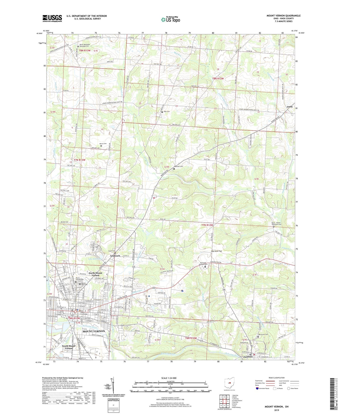
2023 topographic map quadrangle Mount Vernon in the state of Ohio. Scale: 1:24000. Based on the newly updated USGS 7.5' US Topo map series, this map is in the following counties: Knox. The map contains contour data, water features, and other items you are used to seeing on USGS maps, but also has updated roads and other features. This is the next generation of topographic maps. Printed on high-quality waterproof paper with UV fade-resistant inks.
Quads adjacent to this one:
West: Fredericktown
Northwest: Bellville
North: Butler
Northeast: Jelloway
East: Danville
Southeast: Martinsburg
South: Hunt
Southwest: Homer
This map covers the same area as the classic USGS quad with code o40082d4.
Contains the following named places: Academia, Academia Post office, Acland House, Adams Run, Amity, Apple Hill Orchards, Arch Avenue Park, Bailey House, Baker - Barker - Patterson Cemetery, Ball Dairy Farm, Berlin Church, Berlin Methodist Episcopal Cemetery, Bexley Hall, Big Spring Farm, Buckingham Court, Camp Cornish, Camp Sychar, Center Farm, Center Run, Central School, Christian and Missionary Alliance Church, Church of the Nazarene, City of Mount Vernon, Clinton, Colburn Hall, Coleman Branch, College Township Fire Department, College Township Volunteer Fire Department Station 2, Columbia Elementary School, Cromwell House, Crozier Center, Curtis Run, Dan Emmett Elementary School, Davis House, Dry Creek, Dry Run, East Elementary School, East Gambier Street Historic District, East High Street Historic District, Eastern Star Home, Ebenezer Cemetery, Ebenezer Church, Epworth Methodist Church, Farr Hall, First Baptist Church, First Congregational Church, First Presbyterian Church, First Wesleyan Methodist Church, Fleaville, Foursquare Gospel Church, Fourth Ward School, Gambier, Gambier Post Office, Gambier Town Hall, Gay Street Methodist Church, Gund Commons, Gund Hall, Hiawatha School, Hill Grove School, Horwitz House, Knox Community Hospital, Knox County, Knox County Courthouse, Knox County Fairgrounds, Knox County Jail, Knox County Opportunity Center, Knox County Sheriff's Office, Knox Vernon Speedway, Knox Woods State Nature Preserve, Lake Hiawatha, Lamartine Square, Lewis Hall, Little Schenck Creek, Mayer Art Center, Memorial Gardens Cemetery, Memorial Hospital, Memorial Park, Mercy Hospital, Morris Cemetery, Mound View Cemetery, Mount Calvary Baptist Church, Mount Calvary Cemetery, Mount Vernon, Mount Vernon Academy, Mount Vernon City Hall, Mount Vernon Fire Department Station 491, Mount Vernon High School, Mount Vernon Middle School, Mount Vernon Nazarene College, Mount Vernon Police Department, Mount Vernon Post Office, Mount Vernon Shopping Plaza, Mount Vernon State Hospital, Mud Run, Mulberry Methodist Church, North Main-North Gay Streets Historic District, North Mount Vernon, Norton Hall, Oak Grove Cemetery, Oak Grove School, Palme House, Pea Vine Flat, Phillips Park, Pike Cemetery, Pike School, Pleasant Street Elementary School, Public Library of Mount Vernon and Knox County, Saint Pauls Episcopal Church, Saint Vincent De Paul Roman Catholic Church, Saint Vincent De Paul School, School Number 1, School Number 3, School Number 5, Seitz House, Six Corners, Skeen Cemetery, Snowden Multicultural Center, South Mount Vernon, Spring Farm, Springfield Farm, Township of Monroe, Trinity Assembly of God Church, Valley Grove School, Valley School, Vaughan Court, Village of Gambier, Vine Street Church of Christ, Weaver Cottage, West Elementary School, WMVO-AM (Mount Vernon), Wolf Run, WQIO-FM (Mount Vernon)