MyTopo
New Carlisle Ohio US Topo Map
Couldn't load pickup availability
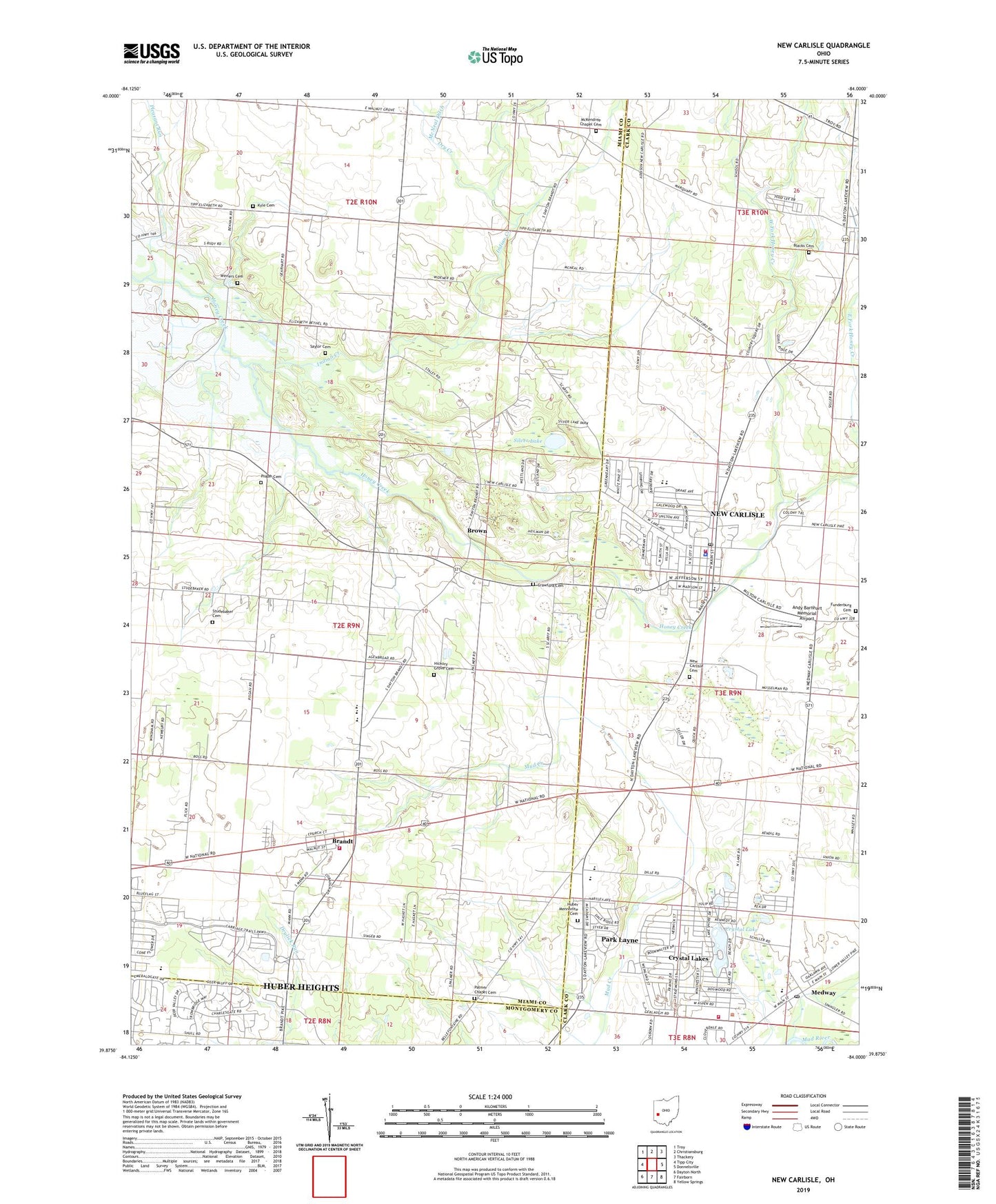
2019 topographic map quadrangle New Carlisle in the state of Ohio. Scale: 1:24000. Based on the newly updated USGS 7.5' US Topo map series, this map is in the following counties: Miami, Clark, Montgomery. The map contains contour data, water features, and other items you are used to seeing on USGS maps, but also has updated roads and other features. This is the next generation of topographic maps. Printed on high-quality waterproof paper with UV fade-resistant inks.
Quads adjacent to this one:
West: Tipp City
Northwest: Troy
North: Christiansburg
Northeast: Thackery
East: Donnelsville
Southeast: Yellow Springs
South: Fairborn
Southwest: Dayton North
Contains the following named places: Andy Barnhart Memorial Airport, Bethel Township Fire Department, Bethel Township Hall, Bethel Township School, Blacks Cemetery, Blacks School, Brandt, Brandt Census Designated Place, Brandt Evangelical Lutheran Church, Brandt Post Office, Brandt School, Brandt United Methodist Church, Brookwood Mobile Home Park, Brown, Center School, City of New Carlisle, Country Haven Mobile Home Park, Cove Springs United Church of Christ, Crawford Cemetery, Crystal Lake, Crystal Lakes, Crystal Lakes Census Designated Place, Crystal Lakes Mobile Home Park, Dry Creek, Duncan Church, East Fork Honey Creek, Elizabeth Elementary School, Fairview School, First United Methodist Church of New Carlisle, Funderberg, Funderburg Cemetery, Glenwood School, Hickory Grove Cemetery, Hickory Grove School, Honey Creek Presbyterian Church, Honey Creek Village Mobile Home Park, Huber Church, Huber Mennonite Cemetery, Indian Creek, Kyle Cemetery, Kyle School, Litteral Stud Farm, McAdams School, McKendree Chapel Cemetery, McKendree Church, Medway, Medway Census Designated Place, Medway Elementary School, Medway Post Office, Medway United Methodist Church, New Carlisle, New Carlisle Cemetery, New Carlisle Church of the Brethren, New Carlisle Fire Division, New Carlisle Middle School, New Carlisle Post Office, New Carlisle Public Library, Oak Grove School, Ohio Valley Farms, Old Stanley Mill, Palmer Chapel Cemetery, Palmer Chapel Methodist Church, Park Layne, Park Layne Census Designated Place, Park Layne Elementary School, Park Layne Manor, Park Layne Manor Shopping Center, Park Terrace Mobile Home Park, Partin Tree Farm, Pisgah Cemetery, Pisgah Chapel, Pleasant Run, Pleasant Run Farm, Ramsey School, Reciprocity Farm, Sacred Heart Catholic Church, Saylor Cemetery, Schauers Acres, Silver Lake, Smith Park, Studebaker Cemetery, Sugar Isle Golf Course, Sunshine Mobile Home Park, Teneicks School, Thompson Airfield, Thompson School, Township of Bethel, West Fork Honey Creek, Westlake Elementary School, Willowick, Winters Cemetery, ZIP Codes: 45341, 45344