MyTopo
Yellow Springs Ohio US Topo Map
Couldn't load pickup availability
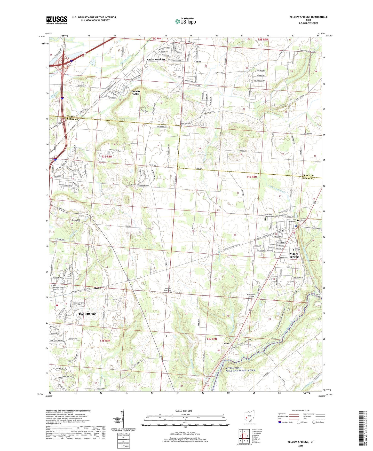
2023 topographic map quadrangle Yellow Springs in the state of Ohio. Scale: 1:24000. Based on the newly updated USGS 7.5' US Topo map series, this map is in the following counties: Greene, Clark. The map contains contour data, water features, and other items you are used to seeing on USGS maps, but also has updated roads and other features. This is the next generation of topographic maps. Printed on high-quality waterproof paper with UV fade-resistant inks.
Quads adjacent to this one:
West: Fairborn
Northwest: New Carlisle
North: Donnelsville
Northeast: Springfield
East: Clifton
Southeast: Cedarville
South: Xenia
Southwest: Bellbrook
This map covers the same area as the classic USGS quad with code o39083g8.
Contains the following named places: Antioch University, Bath Township Office, Bath Township Park, Black Lane Elementary School, Byron, Byron Cemetery, Byron Church, Byron Post Office, Clear Creek, Conner Branch, Coyote Run, Ellis Park, Fairborn Fire Department Station 2, Fairborn Fire Department Station 3, Fairborn Limestone Quarry, First Baptist Church, First Presbyterian Church, Gaunt Park, Glen Forest Cemetery, Glen Helen Bridge, Glen Helen Nature Preserve, Goes, Goes Post Office, Green Meadows, Green Meadows Census Designated Place, Greene Country Club, Greene Joint Vocational School, Greenon High School, Hammond Airport, Hennessee, Hennessey, Holiday Valley, Holiday Valley Census Designated Place, Houck Meadows, Hustead Elementary School, Hydebrook Airport, Indian Valley Estates, Indian Valley Middle School, Jacoby Branch, Little Miami State Forest Preserve, Maple Grove Mobile Home Park, Miami Township Fire and Rescue, Mills Lawn Elementary School, Mud Run Cemetery, Oak Grove School, Oakgrove, Pitstick Pork Farms, Pleasant Grove Cemetery, Pleasant Grove Church, Reeds Hill, Rocky Point Chapel, Rona Hills Park, Saint Andrew Lutheran Church, Saint Pauls Catholic Cemetery, Saint Pauls Church, Tecumseh Estates, Tiffany Acres, Township of Mad River, Twin Towers County Park, Village of Enon, Village of Yellow Springs, Warden Ditch, WCDR-FM (Cedarville), West Enon Estates, WYSO-FM (Yellow Springs), Yellow Springs, Yellow Springs Creek, Yellow Springs High School, Yellow Springs Historic District, Yellow Springs Police Department, Yellow Springs Post Office, Yellow Springs United Methodist Church, ZIP Codes: 45323, 45324, 45387