MyTopo
Newark Ohio US Topo Map
Couldn't load pickup availability
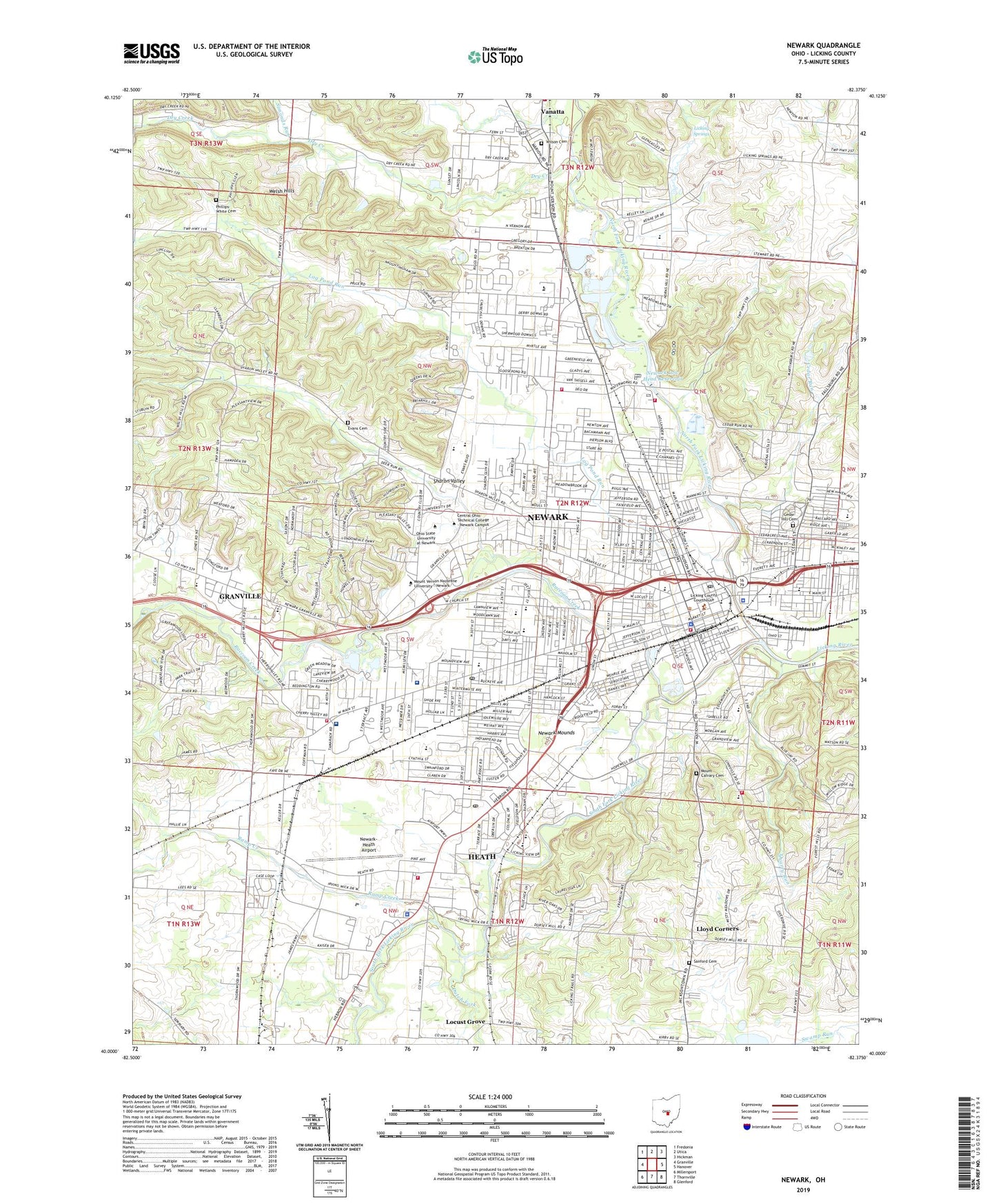
2023 topographic map quadrangle Newark in the state of Ohio. Scale: 1:24000. Based on the newly updated USGS 7.5' US Topo map series, this map is in the following counties: Licking. The map contains contour data, water features, and other items you are used to seeing on USGS maps, but also has updated roads and other features. This is the next generation of topographic maps. Printed on high-quality waterproof paper with UV fade-resistant inks.
Quads adjacent to this one:
West: Granville
Northwest: Fredonia
North: Utica
Northeast: Hickman
East: Hanover
Southeast: Glenford
South: Thornville
Southwest: Millersport
This map covers the same area as the classic USGS quad with code o40082a4.
Contains the following named places: Arnold Park, Blanchard, Blessed Sacrament School, Blessed Sacrement Catholic Church, Cedar Hill Cemetery, Cedar Run, Central Christian Church, Central Church of the Nazarene, Central City, Central Junior High School, Central Primary School, Cherry Valley Elementary School, Cherry Valley Prairie, Christ United Methodist Church, Christian and Missionary Alliance Church, Christian Apostolic Church, Church of Christ, Church of God, Church of the Nazarene, City of Heath, City of Newark, Conrad Elementary School, Courtesy Ambulance, Cox United Methodist Church, Denman Park, Dry Creek, Dugway Shopping Center, Dutch Fork, Edwards Field, Evans Family Park, Everett Park, Faith United Methodist Church, First Baptist Church, First Church of Christ Scientist, First Church of the Nazarene, First Presbyterian Church, First Trinity Assembly of God Church, First United Brethren Church, First United Methodist Church, First Wesleyan Methodist Church, Forest Hills Golf Club, Four Square Gospel Tabernacle, Franklin Junior High School, Fulton Elementary School, Garfield Elementary School, German Salem Presbyterian Church, Hartzler Elementary School, Heath, Heath Christian Union Church, Heath Community Park, Heath Fire Department Station 1, Heath Fire Department Station 2, Heath High School, Heath Police Department, Heath Post Office, Heath Sewage Treatment Plant, Heath Water Treatment Plant, Hobak Park, Hog Hollow, Holy Trinity Lutheran Church, Horns Hill Park, Hudson Avenue Historic District, Hudson Avenue School, Idlewild Park, Indian Mound Mall Shopping Center, Indian Valley Mall Shopping Center, John Clem Elementary School, Keller Elementary School, Kettering Elementary School, Kingdom Hall of Jehovahs Witnesses, Lake Kennedy, Levin Park, Licking County, Licking County Courthouse, Licking County Historical Society, Licking County Joint Vocational School, Licking County Sanitarium, Licking County Sheriff's Office, Licking Memorial Hospital, Licking Memorial Hospital Heliport, Licking Springs, Licking Springs Golf Course, Lincoln Middle School, Lloyd Corners, Locust Grove, Log Pond Run, Maholm Elementary School, Maple Avenue Christian Union Church, McGuffey Elementary School, Mound Builders Country Club, Mound School, Moundbuilders State Memorial, Moundbuilders Station Newark Post Office, Mount Calvary Cemetery, Neal Avenue United Methodist Church, Newark, Newark Brethren Church, Newark Catholic High School, Newark Fire Department and Emergency Medical Services Station 1, Newark Fire Department Station 2, Newark Fire Department Station 3, Newark High School, Newark Hospital, Newark Low Head Dam, Newark Low Head Reservoir, Newark Memorial Gardens, Newark Mounds, Newark Municipal Building, Newark Plaza Shopping Center, Newark Police Department, Newark Post Office, Newark Public Library, Newark Township Fire Department, Newark Water Works, Newark-Heath Airport, Newton Chapel, North Central Ohio Technical College, North Elementary School, North Fork Licking River, Octagon State Memorial, Ohev Israel Temple, Ohio State University Newark Branch, Oneness Apostolic Church, Phillips-White Cemetery, Pine Street Christian Union Church, Planevue Airport, Plymouth United Church of Christ, Quarry Run, Raccoon Creek, Ramp Creek, Roosevelt Middle School, Saint Francis De Sales Catholic Church, Saint Francis De Sales School, Saint Johns United Church of Christ, Saint Pauls Lutheran Church, Sanford Cemetery, Second Baptist Church, Second Church of Christ, Second Presbyterian Church, Select Specialty Hospital - Southeast Ohio, Seventh Day Adventist Church, Sharon Valley, Sharon Valley Cemetery, Shepherd Hill Hospital, Shiloh Baptist Church, Simonds Run, Sixth Street Church of God, Soldiers and Sailors Memorial Building, South Fork Licking River, Southgate Corners Shopping Center, Southgate Shopping Center, Standard Church of Christ, Stevenson Elementary School, Stoney Creek Farm Heliport, Township of Newark, Trinity African Methodist Episcopal Church, Trinity Episcopal Church, Vinela Farm, WCLT-AM (Newark), WCLT-FM (Newark), Welsh Church, Welsh Hills, Welsh Hills Church, Western Avenue Primitive Baptist Church, White Field, WHTH-AM (Heath), Wilson Cemetery, Wilson Middle School, Woodside Presbyterian Church, Woodside School, Wright Memorial United Methodist Church, ZIP Code: 43055