MyTopo
Oberlin Ohio US Topo Map
Couldn't load pickup availability
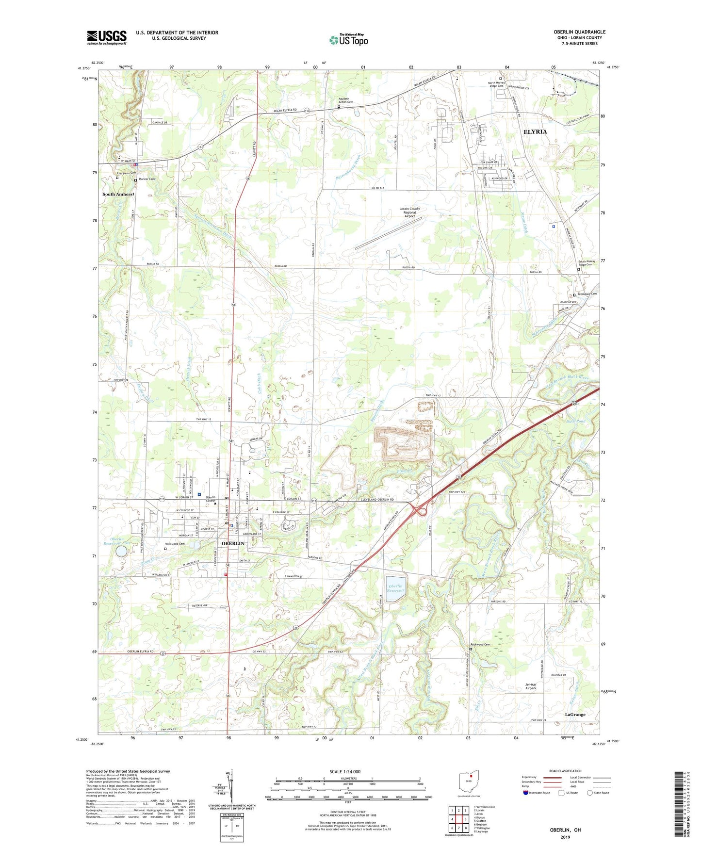
2023 topographic map quadrangle Oberlin in the state of Ohio. Scale: 1:24000. Based on the newly updated USGS 7.5' US Topo map series, this map is in the following counties: Lorain. The map contains contour data, water features, and other items you are used to seeing on USGS maps, but also has updated roads and other features. This is the next generation of topographic maps. Printed on high-quality waterproof paper with UV fade-resistant inks.
Quads adjacent to this one:
West: Kipton
Northwest: Vermilion East
North: Lorain
Northeast: Avon
East: Grafton
Southeast: Lagrange
South: Wellington
Southwest: Brighton
This map covers the same area as the classic USGS quad with code o41082c2.
Contains the following named places: Agudath Achim Cemetery, Allen Art Building, Apollo Theater, Battenhouse Ditch, Brookdale Cemetery, Carnegie Library, Chapel of the Sacred Heart of Jesus, Christ Episcopal Church, Christ Temple Church, Christian and Missionary Alliance Church, Church of the Nativity, Church of the Open Door, City of Oberlin, City of Oberlin Water Treatment Facility, Cobb Ditch, Congregational Church of Christ, Dechant Farms Airport, Duck Pond, Dudley Ditch, East Oberlin Community Church, Eastwood Elementary School, El Rey Grotto Park, Elk Creek, Elyria Country Club, Evergreen Cemetery, Finney Chapel, First Baptist Church, First Methodist Episcopal Church, Forest Hill Country Club, Glorious Church of God in Christ, Good Hope Church, Grace Lutheran Church, Green Acres Childrens Home, Grobe Fruit Farm, Hall Auditorium, Hazel Webber Home for Girls, Herrick Ditch, James Bryant Chapel, Jer-Mar Airpark, Jones Field House, Kelner Ditch, Langston Middle School, Lorain County Landfill, Lorain County Regional Airport, Lorain County Speedway, Lorain Detention Home, Lorain School for Retarded Children, Lorian County Sheriff's Office, Mercy Health - Allen Hospital, Midway Golf Club, Mount Zion Baptist Church, Nickelplate, Nickelplate Post Office, North Murray Ridge Cemetery, Oberlin, Oberlin Business College, Oberlin City Hall, Oberlin College, Oberlin Country Club, Oberlin Fire Department, Oberlin High School, Oberlin Police Department, Oberlin Post Office, Oberlin Reservoir, Oberlin Reservoir - 011, Oberlin Reservoir Dam, Oberlin Upground Reservoir Dam, Open Door Christian School, Pioneer Cemetery, Pleasant Street School, Plum Creek, Prospect Elementary School, Rice Memorial Hall, Robin Park, Rockwood Cemetery, Rust Church, Sacred Heart Church, Schroeder Ditch, Second Congregational Church, Shiperd Circle, South Amherst Congregational Church, South Amherst Elementary School, South Amherst Fire Department, South Amherst First United Methodist Church, South Amherst Middle School, South Amherst Police Department, South Murray Ridge Cemetery, South Ridge School, Squires Ditch, Squires Schramm Ditch, Straw Ditch, Tappan Square, Township of New Russia, Township of Russia, Twin Lakes Homes, Village of South Amherst, Vita-ful Orchards, Warner Center, Warner Gymnasium, Wellington Creek, West Ridge Green, Westwood Cemetery, Whiskyville, William R Burton Vocational School, WOBC-FM (Oberlin), WOBL-AM (Oberlin), Zion Evangelical Lutheran Church, ZIP Codes: 44035, 44074