MyTopo
Grafton Ohio US Topo Map
Couldn't load pickup availability
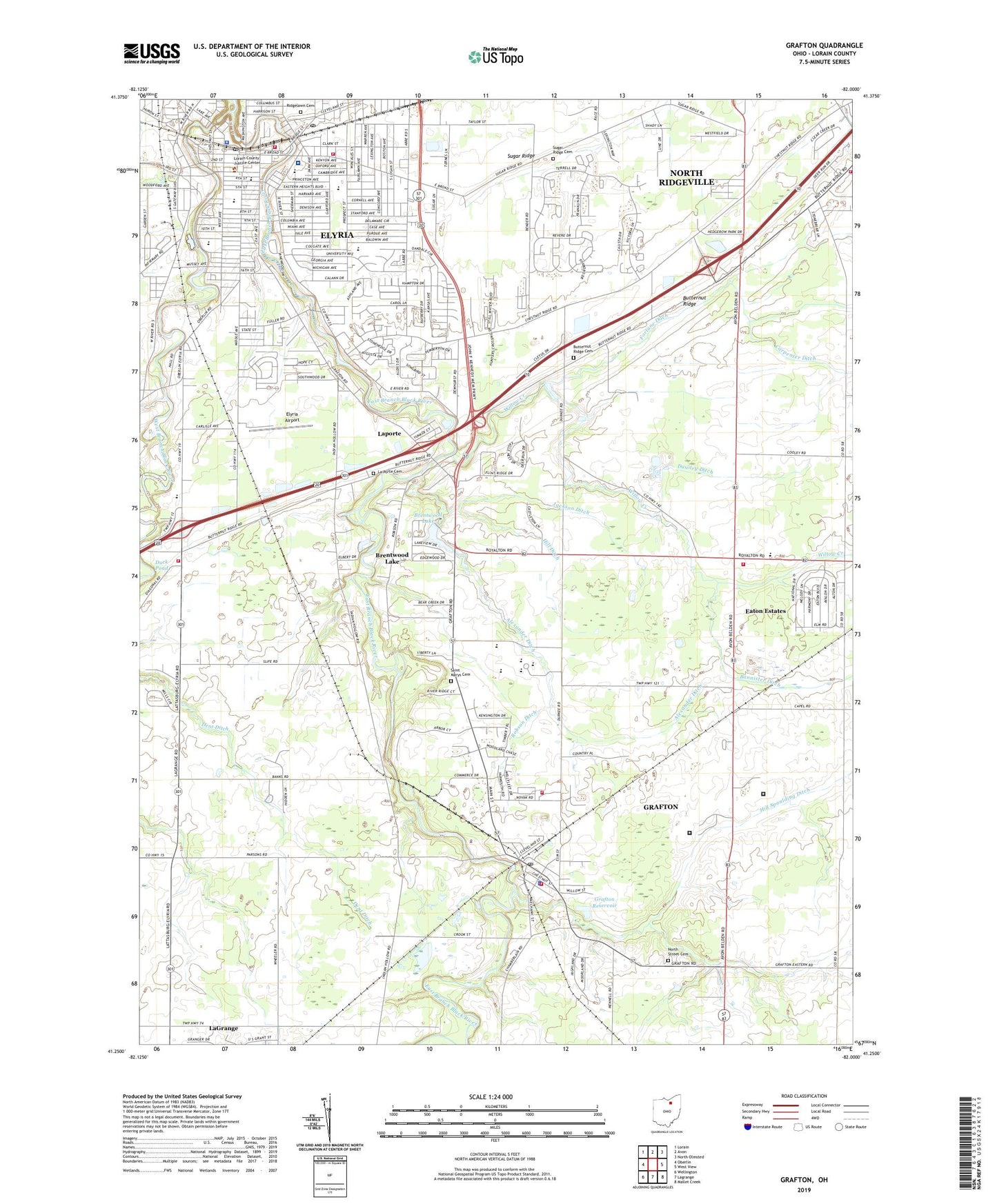
2023 topographic map quadrangle Grafton in the state of Ohio. Scale: 1:24000. Based on the newly updated USGS 7.5' US Topo map series, this map is in the following counties: Lorain. The map contains contour data, water features, and other items you are used to seeing on USGS maps, but also has updated roads and other features. This is the next generation of topographic maps. Printed on high-quality waterproof paper with UV fade-resistant inks.
Quads adjacent to this one:
West: Oberlin
Northwest: Lorain
North: Avon
Northeast: North Olmsted
East: West View
Southeast: Mallet Creek
South: Lagrange
Southwest: Wellington
This map covers the same area as the classic USGS quad with code o41082c1.
Contains the following named places: Alexander Ditch, Asbury United Methodist Church, Bethany Baptist Church, Brentwood Golf Course, Brentwood Lake, Brentwood Lake Dam, Brush Elementary School, Butternut Ridge Cemetery, Carlisle Township Fire Station, Carpenter Ditch, Carroll's Airport, Church of God of Prophecy, Colonial Oaks, Coonville, Dawley Ditch, Dent Ditch, East Branch Black River, East Carlisle Elementary School, Eastern Heights Middle School, Eastgate Elementary School, Eaton, Eaton Estates, Eaton Estates Census Designated Place, Eaton School, Eaton Township Fire and Rescue, Eaton Township Hall, Ely Park, Ely Stadium, Elyria, Elyria Airport, Elyria Baptist Church, Elyria Church of the Nazarene, Elyria Fire Department - Central Station, Elyria Fire Department - Station 1, Elyria High School, Elyria Memorial Hospital Heliport, Elyria Methodist Home, Elyria Police Department, Elyria Post Office, Elyria Public Library, Elyria Shopping Center, Elyria South Park, Emanuel Lutheran Church, Finnegan Ditch, First Baptist Church, First Church of Christ Scientist, First Congregational Church, First United Methodist Church, First United Presbyterian Church, Fortune Ditch, Franklin Elementary School, Garford School, Gates Hospital, Gates School, Grafton, Grafton Correctional Institution, Grafton Elementary School, Grafton Police Department, Grafton Post Office, Grafton Reservoir, Grafton Reservoir Dam, Grafton State Farm, Grafton Village Fire Department Station 1, Grafton Village Fire Department Station 2, Greater Christ Temple, Hamilton School, Hill Airport, Hill Ditch, Hill Spaulding Ditch, Holy Cross Polish Roman Catholic Church, Holy Cross School, Immaculate Conception Church, Jackson Ditch, Jones Chapel African Methodist Episcopal Church, King Ditch, Kingdom Hall of Jehovahs Witnesses, Kingsleys Corners, La Porte Cemetery, La Porte Post Office, Lake Avenue United Church of Christ, Laporte, LifeCare Ambulance - Elyria Station, Lorain Correctional Institute, Lorain County Courthouse, Lorain County Jail, Lorain County Law Library, Magyar United Church of Christ, McKinley Elementary School, Midview High School, Midview Middle School, North Ridgeville Fire Department Station 2, North Street Cemetery, Ohio State Highway Patrol - Elyria Patrol Post, Original Church of God, Pilgrim United Church of Christ, Pine Brook Golf Course, Prospect Elementary School, Ridgelawn Cemetery, Riverview Mobile Home Park, Riverview Plaza, Robson Ditch, Roosevelt Elementary School, Sacred Heart Roman Catholic Church, Saint Andrews Episcopal Church, Saint John Lutheran School, Saint Johns Church, Saint Mary School, Saint Marys Cemetery, Saint Marys Roman Catholic Church, Saint Pauls Evangelical Church, Sugar Ridge, Sugar Ridge Cemetery, Taylor Woods Industrial Park, Ternes Field, Township of Carlisle, Township of Eaton, University Hospitals - Elyria Medical Center, Village of Grafton, Washington Avenue Christian Church, Washington Avenue Historic District, Washington High School, WEOL-AM (Elyria), West Branch Black River, West Carlisle Elementary School, Willow Creek, Willow Park, Wilsons Private Airport, WNWV-FM (Elyria), ZIP Code: 44044