MyTopo
Plainfield Ohio US Topo Map
Couldn't load pickup availability
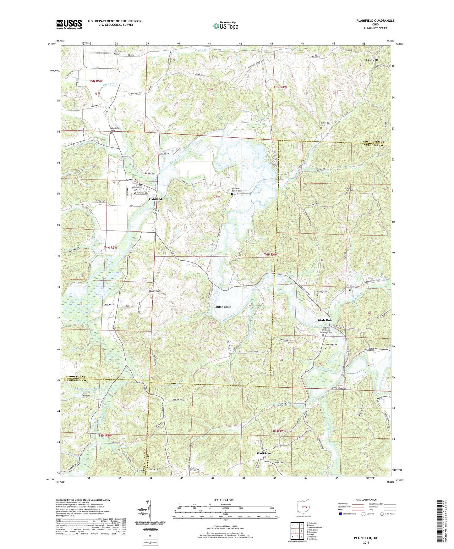
2023 topographic map quadrangle Plainfield in the state of Ohio. Scale: 1:24000. Based on the newly updated USGS 7.5' US Topo map series, this map is in the following counties: Coshocton, Guernsey, Muskingum. The map contains contour data, water features, and other items you are used to seeing on USGS maps, but also has updated roads and other features. This is the next generation of topographic maps. Printed on high-quality waterproof paper with UV fade-resistant inks.
Quads adjacent to this one:
West: Wills Creek
Northwest: Coshocton
North: Fresno
Northeast: Newcomerstown
East: Kimbolton
Southeast: Cambridge
South: Bloomfield
Southwest: Otsego
This map covers the same area as the classic USGS quad with code o40081b6.
Contains the following named places: Bacon Run, Banker Cemetery, Birds Run, Birds Run Methodist Episcopal Cemetery, Birds Run Post Office, Block School, Bucker School, Carr School, Center Creek, Community Church, Cooks Corners, Darrow Lake, Darrow Lake Dam, Darrow Pond Dam, Flat Ridge, Flat Ridge Cemetery, Flat Ridge Post Office, Forney Cemetery, Indian Camp Run, Lake Lila, Lawyers Corners, Linton Mills, Linton Mills Post Office, Little Indian School, Low Gap, Low Gap School, Marlatt School, McCune School, Miskimen Family Cemetery, Morrison Corners, North Bend School, Peabody Coal Company Pond 0115-011, Peabody Coal Company Pond 0115-011 Dam, Plainfield, Plainfield Cemetery, Plainfield Elementary School, Plainfield Grange Hall, Plainfield Post Office, Plainfield United Methodist Church, Red Brush School, Roahrig Hill, Sandbank School, Schweitzer Cemetery, Stringtown, Toledoville, Township of Linton, Tri-City Airport, Twomile Run, Union Hill Cemetery, Union Hill School, Village of Plainfield, White Eyes Creek, Williams School, Wolf Run, Worthing Cemetery, ZIP Code: 43836