MyTopo
South Lebanon Ohio US Topo Map
Couldn't load pickup availability
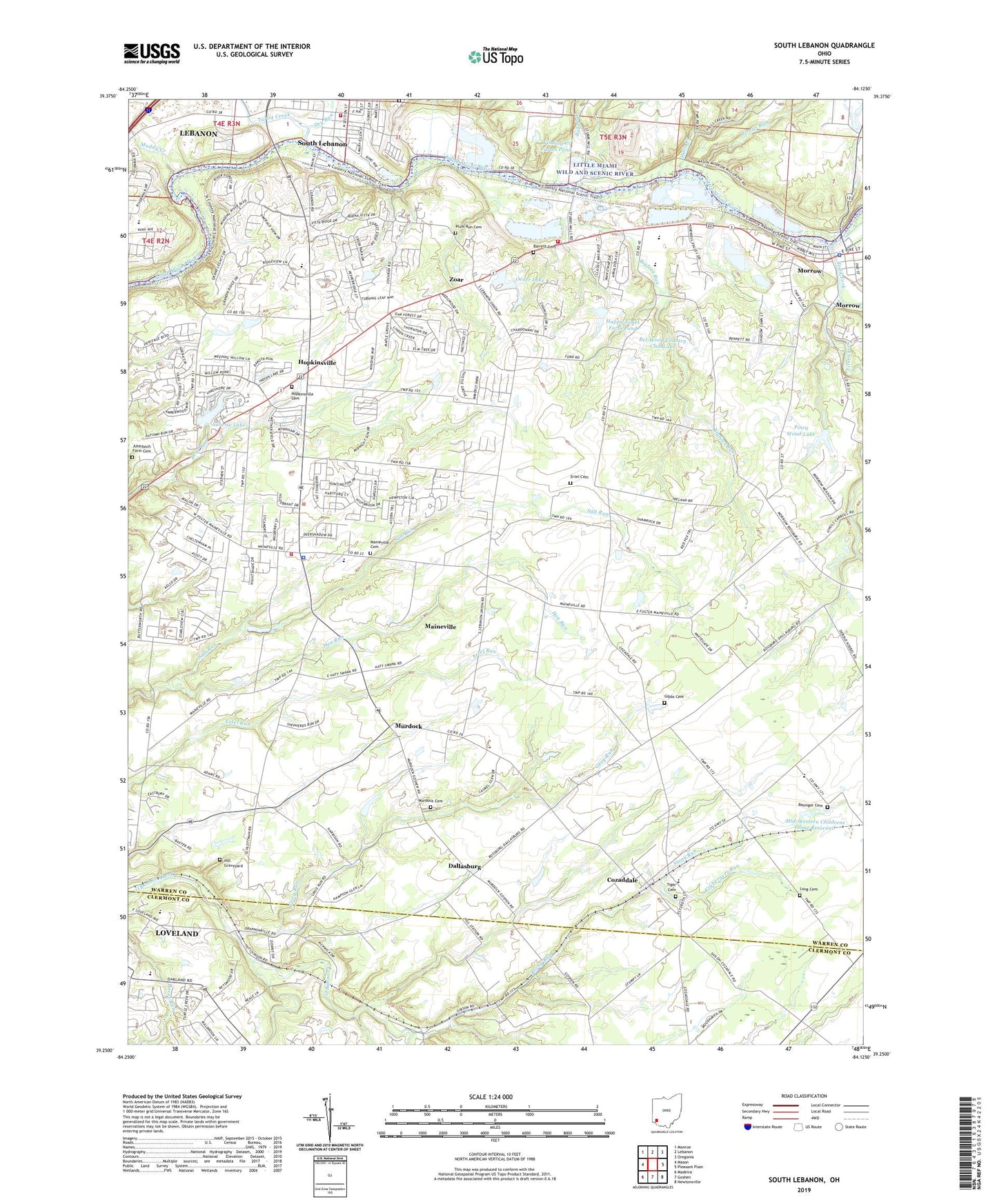
2019 topographic map quadrangle South Lebanon in the state of Ohio. Scale: 1:24000. Based on the newly updated USGS 7.5' US Topo map series, this map is in the following counties: Warren, Clermont. The map contains contour data, water features, and other items you are used to seeing on USGS maps, but also has updated roads and other features. This is the next generation of topographic maps. Printed on high-quality waterproof paper with UV fade-resistant inks.
Quads adjacent to this one:
West: Mason
Northwest: Monroe
North: Lebanon
Northeast: Oregonia
East: Pleasant Plain
Southeast: Newtonsville
South: Goshen
Southwest: Madeira
Contains the following named places: Bakers Orchard Cemetery, Barrett Cemetery, Basinger Cemetery, Bel-Wood Country Club Lake, Bel-Wood Country Club Lake Dam, Bigfoot Run, Bigfoot Run Sanitary Landfill, Brillwood Farm, Camp Butterworth, Chestnut Ridge School, Chitwood Pond, Chitwood Pond Dam, Comargo, Cow Chip Creek Heliport, Cozaddale, Dallasburg, Deerfield Cemetery, Dry Run, Ertel Cemetery, First Creek, Frybergers Run, Gibbs Cemetery, Grays Run, Greenfield Plant Farm, Grog Run, Halls Creek, Hamilton Township Fire and Rescue Station 76, Hamilton Township Fire and Rescue Station 77, Hamilton-Maineville Elementary School, Happy Times Farm Pond, Happy Times Farm Pond Dam, Hen Run, Hickory Corner, Hill Graveyard, Hill Station Missionary Baptist Church, Hills, Hopkinsville, Hopkinsville Cemetery, Howry Farms, Ingle Cemetery, Juterboch Farm Cemetery, Kings Mills, Kings Mills Elementary School, Little Miami High School, Maineville, Maineville Cemetery, Maineville Police Department, Maineville Post Office, Mary Ellen, Middletown Junction, Mid-Western Childrens Home Dam, Mid-Western Childrens Home Reservoir, Morrow, Morrow Church of the Nazarene, Morrow Elementary School, Morrow Police Department, Morrow Post Office, Morrow United Methodist Church, Muddy Creek, Murdock, Murdock Cemetery, Oak Ridge School, O'Bannon School, Oeder Lake, Oeder Lake Dam, Piney Wood Lake, Piney Wood Lake Dam, Pleasant View School, Plum Run Cemetery, Presbyterian Church of Morrow, Red Sun Farm, Rippe Pond, Rippe Pond Dam, Rohrer Airport, Saint Columban School, Saint Johns Church, Saint Mary Magdalene Episcopal Church, Salem Township Public Library, Smith School, South Lebanon, South Lebanon Elementary School, South Lebanon Methodist Church, South Lebanon Post Office, South Lebanon Town Hall, Stony Run, Stubbs Mill, Sunrise Lake, Sunrise Lake Dam, Tiger Cemetery, Todd Fork, Township of Hamilton, Turtle Creek, Union School, Union Township and South Lebanon Fire Department, Village of Maineville, Village of South Lebanon, Winding Creek Farms Pond, Winding Creek Farms Pond Dam, WLMH-FM (Morrow), Zoar, Zoar Methodist Church, ZIP Codes: 45034, 45039, 45065, 45140