MyTopo
Monroe Ohio US Topo Map
Couldn't load pickup availability
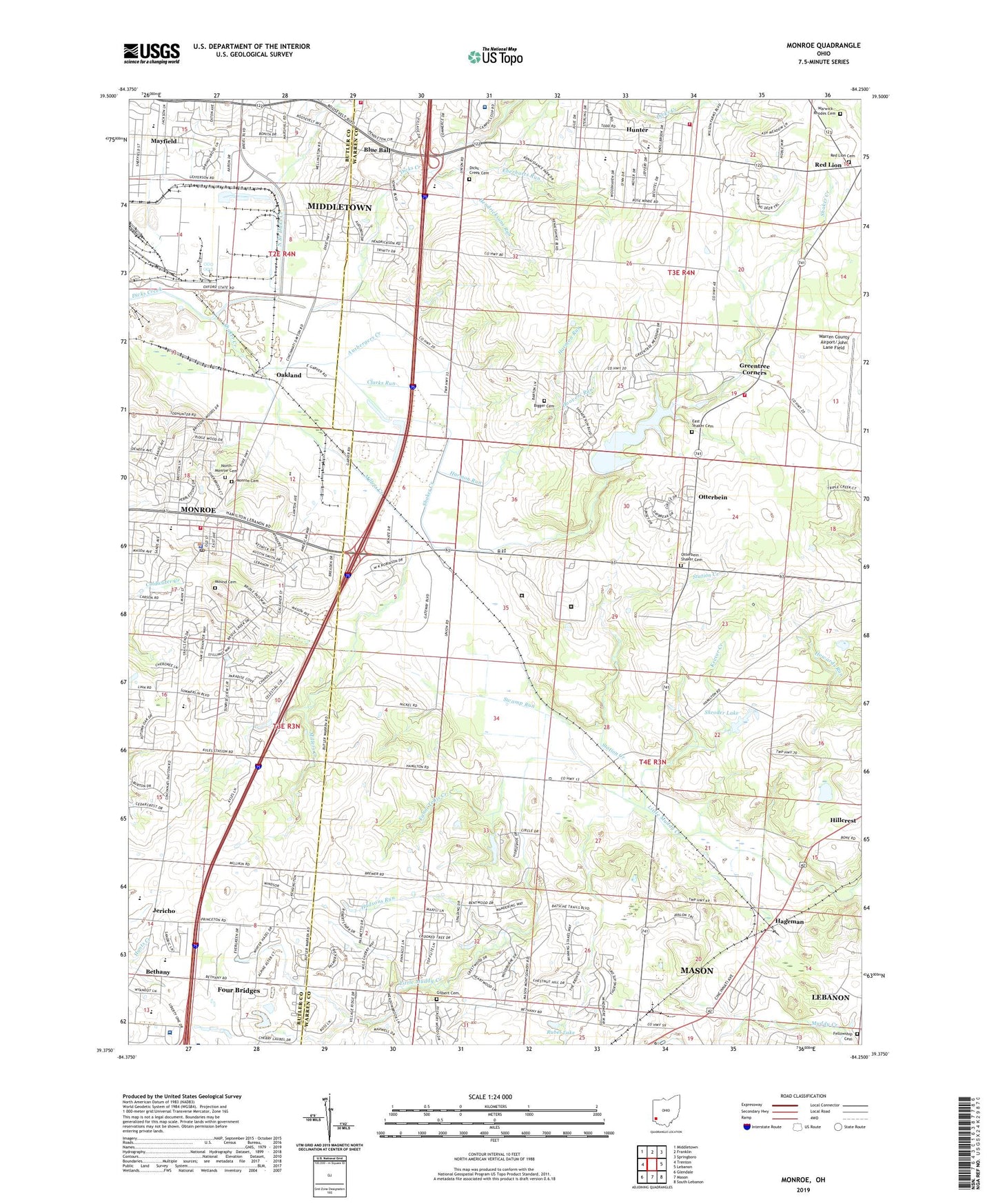
2023 topographic map quadrangle Monroe in the state of Ohio. Scale: 1:24000. Based on the newly updated USGS 7.5' US Topo map series, this map is in the following counties: Warren, Butler. The map contains contour data, water features, and other items you are used to seeing on USGS maps, but also has updated roads and other features. This is the next generation of topographic maps. Printed on high-quality waterproof paper with UV fade-resistant inks.
Quads adjacent to this one:
West: Trenton
Northwest: Middletown
North: Franklin
Northeast: Springboro
East: Lebanon
Southeast: South Lebanon
South: Mason
Southwest: Glendale
This map covers the same area as the classic USGS quad with code o39084d3.
Contains the following named places: Armco Park, Armco Park Lake, Atrium Medical Center, Ausbergers Creek, Beedles Station, Bethany, Bethany Post Office, Bethany United Methodist Church, Bigger Cemetery, Blue Ball, Blue Ball Presbyterian Church, Blueball Post Office, Brittany Heights, Calvary Baptist Church, Cincinnati Children's Hospital Medical Center - Liberty Campus, City of Monroe, Clarks Run, Crooked Tree Golf Course, Dicks Creek Cemetery, District Number 8 Heliport, East Shaker Cemetery, Eastview Church, Eberharts Run, Evergreen Farm Estates, Fanni Tellis Creek, Fellowship Cemetery, Fellowship Church, First Baptist Church, Four Bridges Census Designated Place, Four Bridges Country Club, Franklin Township Fire Department Station 19 Hunter, George M Verity Middle School, Gilbert Cemetery, Grace Baptist Church, Green Crest Golf Course, Greentree Corners, Hageman, Harmon Run, Hendricksons Run, Hillcrest, Hoovers Run, Hudsons Run, Hunter, Hunter Census Designated Place, Hunter Community United Methodist Church, Hunter Elementary School, Jericho, Joint Emergency Medical Services Station 19, Keever Creek, Lakota East High School, Lebanon Correctional Institution, Lefferson Softball Complex, Lemon, Lemon Post Office, Lemon-Monroe High School, Mason Industrial Park, Mayfield, Mayfield Elementary School, Middletown Christian School, Middletown Division of Fire Station 82, Millers Creek, Monroe, Monroe Cemetery, Monroe Elementary School, Monroe Fire Department Station 1, Monroe Lake, Monroe Park, Monroe Police Department, Monroe Post Office, Monroe Water Treatment Plant, Mound Cemetery, Mount Pleasant Presbyterian Church, Nobles Fork, North Branch Dicks Creek, North Monroe Cemetery, Oakland, Otterbein, Otterbein - Shaker Cemetery, Our Lady of Sorrows Catholic Church, Overbrook Business Park, Red Lion Cemetery, Rubel Lake, School Number 2, School Number 6, School Number 8, Shadow Lake, Shadow Lake Dam, Shadow Lake Village, Shaker Creek, Shaker Creek Dam, Shroder Lake, Shroder Lake Dam, Station Creek, Stokes, Swamp Run, Taylor Village, Towne Mall Shopping Center, Township of Turtlecreek, Turtlecreek Township Fire and Emergency Medical Services Station 33 State Route 741, Warren Correctional Institution, Warren County Airport/John Lane Field, Warwick - Rhodes Cemetery, ZIP Code: 45050