MyTopo
Mason Ohio US Topo Map
Couldn't load pickup availability
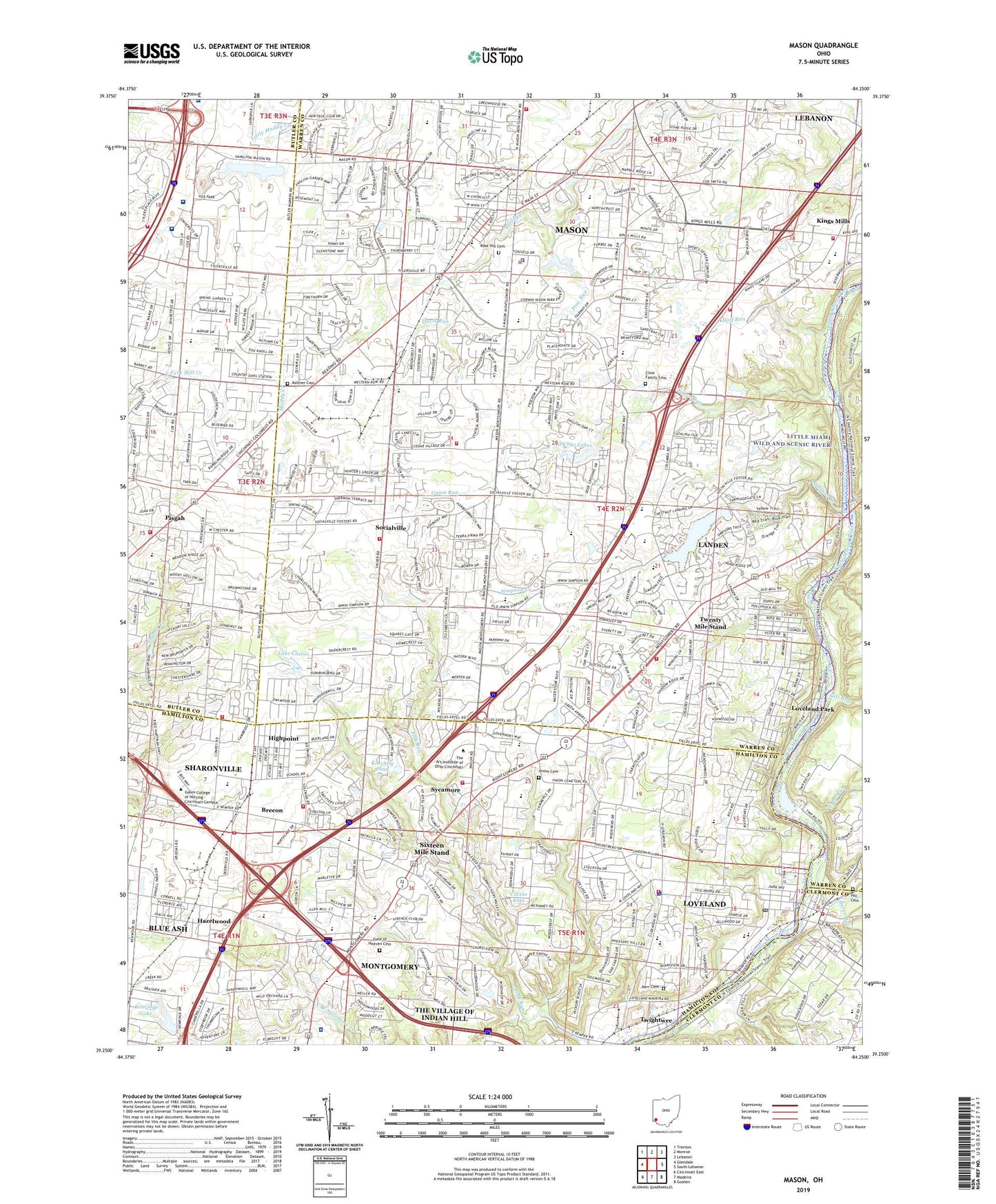
2023 topographic map quadrangle Mason in the state of Ohio. Scale: 1:24000. Based on the newly updated USGS 7.5' US Topo map series, this map is in the following counties: Warren, Hamilton, Butler, Clermont. The map contains contour data, water features, and other items you are used to seeing on USGS maps, but also has updated roads and other features. This is the next generation of topographic maps. Printed on high-quality waterproof paper with UV fade-resistant inks.
Quads adjacent to this one:
West: Glendale
Northwest: Trenton
North: Monroe
Northeast: Lebanon
East: South Lebanon
Southeast: Goshen
South: Madeira
Southwest: Cincinnati East
This map covers the same area as the classic USGS quad with code o39084c3.
Contains the following named places: Al-Char Lake 9242-002, Al-Char Lake Dam 9242-002, Al-Char Lakes, Armrel-Byrnes Heliport, Bares Run, Bear Run, Bethesda North Hospital, Bible Believers Baptist Church, Blue Ash Commerce Center, Blue Ash Industrial Park, Blue Ash Sports Center, Bodley Park, Brecon, Brecon Census Designated Place, Brecon Post Office, Brecon United Methodist Church, Brenner Woods, Brookside Estates, Butterworth, Cactus Lake, Carter Lake, Castle Industrial Park, Church of God, City of Loveland, City of Mason, City of Mason Fire Station 51, City of Mason Fire Station 52, Ciutan Park, Clearview, Cline Family Cemetery, Coach Bud Acus Field, College Football Hall of Fame, Corwin M Nixon Pine Hill Lakes Park, Country Acres, Davis Run, Deerfield Industrial Park, Deerfield Township Fire Rescue Station 56, Deerfield Township Fire Rescue Station 57, Deerfield Township Fire Rescue Station 58, Deerfield Township Hall, Dog Street Cemetery, Duffys Square Shopping Center, Dulle Park, East Loveland Nature Preserve, Emery Acres, Ertel Run, Faith Christian Fellowship Church, Faith Community United Methodist Church, Fire Station Number 2, First Baptist Church of Loveland, First Missionary Baptist Church, Foster, Gate of Heaven Cemetery, Glen Lake Industrial Park, Gray History of Wireless Museum, Hazelwood, Hazelwood Civic Center, Hazlewood Post Office, Hidden Creek Park, High Point Church of God, Highpoint, Highpoint Census Designated Place, Hill - Wagoner Cemetery, Hoff Run, Hopewell Elementary School, Hopewell Middle School, Hopewell School, Hurst Middle School, Independent Bible Church, J F Burns Elementary School, Jack Nicklaus Sports Center, Johnson Nature Preserve, Keltner Cemetery, Kemper Commerce Center, Kenridge, Kenridge Lake, Kerr Cemetery, Kings High School, Kings Island Amusement Park, Kings Island Fire Department, Kings Mall Shopping Center, Kings Mill Business Park, Kings Mills Census Designated Place, Kings Mills Post Office, Kings Stadium, Kingsgate Plaza Shopping Center, Kings-Mason Plaza Shopping Center, Kingswood Golf Course, Kiwanis Park, Knechtly Pond, Knechtly Pond Dam, Lake Chetac, Landen, Landen Census Designated Place, Landen Farm Dam, Landen Farm Lake, Landen Square Shopping Center, Landen-Deerfield Park, Lebanon Road Church, Lever Park, Linder Center of Hope, Lloyd Mann Elementary School, Loveland, Loveland - Symmes Fire Department Station 61, Loveland - Symmes Fire Department Station 62, Loveland - Symmes Fire Department Station 63, Loveland City Hall, Loveland Heights Church of Christ, Loveland High School, Loveland Historical Museum, Loveland Middle School, Loveland Park, Loveland Park Census Designated Place, Loveland Police Department, Loveland Post Office, Loveland Presbyterian Church, Loveland Primary School, Loveland Shopping Center, Loveland-Miami Elementary School, Mason, Mason Heights Elementary School, Mason High School, Mason Interstate Industrial Park, Mason Middle School, Mason Mobile Home Park, Mason Police Department, Mason Post Office, McCoy Park, McGinnis Park, Meadows Park, Miltomson, Oakwood Park, O'Bannon Creek, Orchard Acres, Phillips Park, Pine Hill Lake, Pine Hill Lake Dam, Pine Run, Pisgah, Pisgah Post Office, Pisgah Youth Park, Quinn Park, Rose Hill Cemetery, Saint Susanna Catholic Church, Saint Susanna School, Salt Run, School Number 2, Seven Gables Park, Sharonville Fire Department Station 88, Shawnee Mobile Home Court, Shoppers Haven Shopping Center, Simpson Creek, Sixteen Mile Stand, Sixteen Mile Stand Census Designated Place, Sixteen Mile Stand Post Office, Skyline Business Park, Snidercrest, Socialville, Socialville Baptist Church, Somerset Church, Stewart Elementary School, Stonebridge Park, Stonewall Estates, Sunburst Hills, Sycamore, Sycamore High School, Sycamore Township Emergency Medical Services and Fire Department Station 93, Sycamore United Presbyterian Church, Symmes Post Office, Symmes Square Shopping Center, Symmes Township Building, Symmes Township Park, Tanager Wood Golf Club, The West Chester Hospital Surgical Center, The Woods, Township of Deerfield, Township of Symmes, Twenty Mile Stand, Twightwee, UC Health West Chester Hospital, Union Cemetery, Union Run, United Heliport, Van Leunens Shopping Center, Vineyard Community Church, VOA Shopping Center, Voice of America Park, Weller Park, West Chester Fire Station 75, West Chester Township Fire Department Station 72, Westchester Plaza Shopping Center, Western Row Elementary School, Western Row Golf Course, Western Row Industrial Park, Wildwood Acres, WLHS-FM (West Chester), WLW-AM (Cincinnati), WZRZ-FM (Hamilton), Youngs Field, Zion Hill Baptist Church, ZIP Codes: 45040, 45249