MyTopo
Tiltonsville Ohio US Topo Map
Couldn't load pickup availability
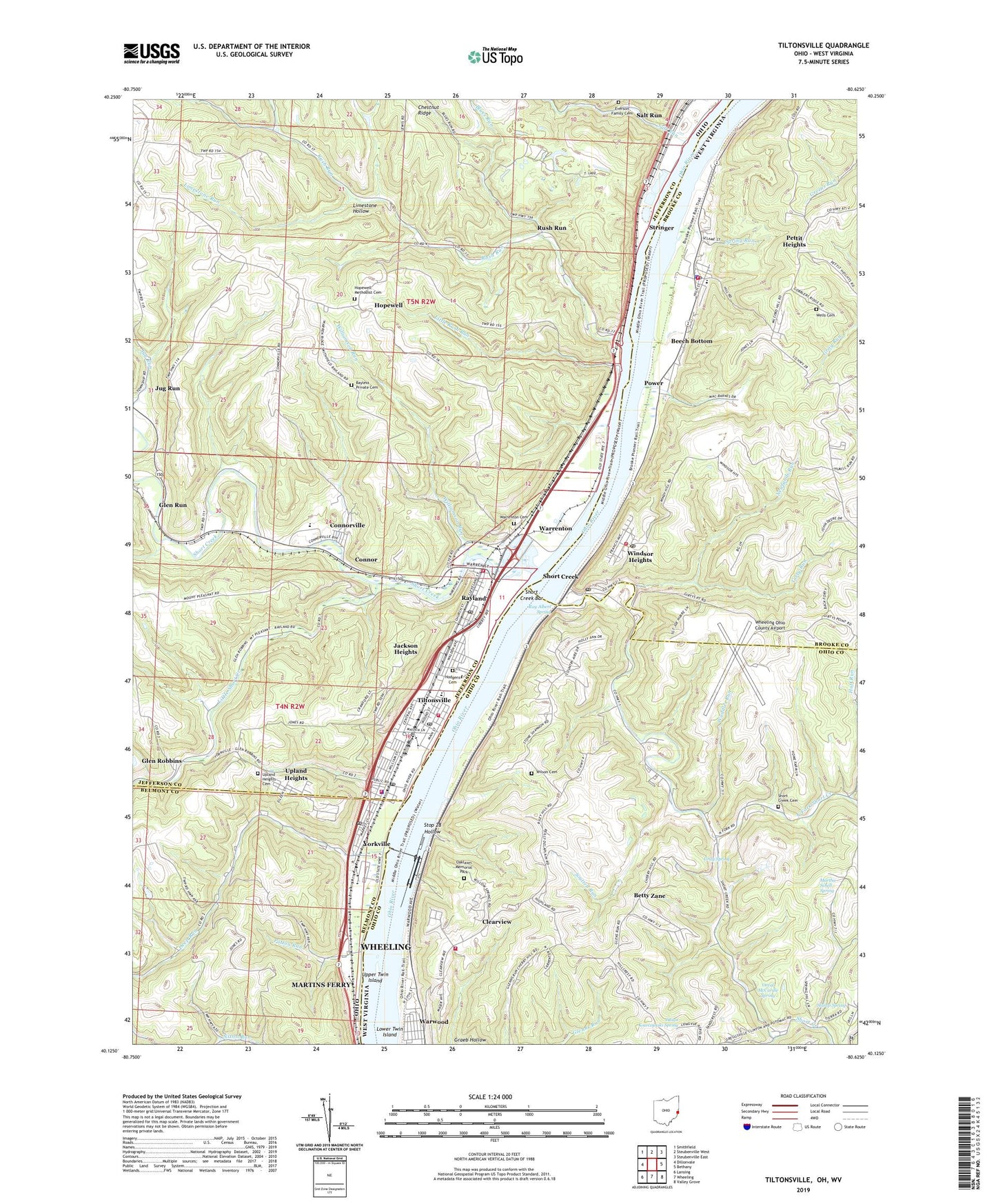
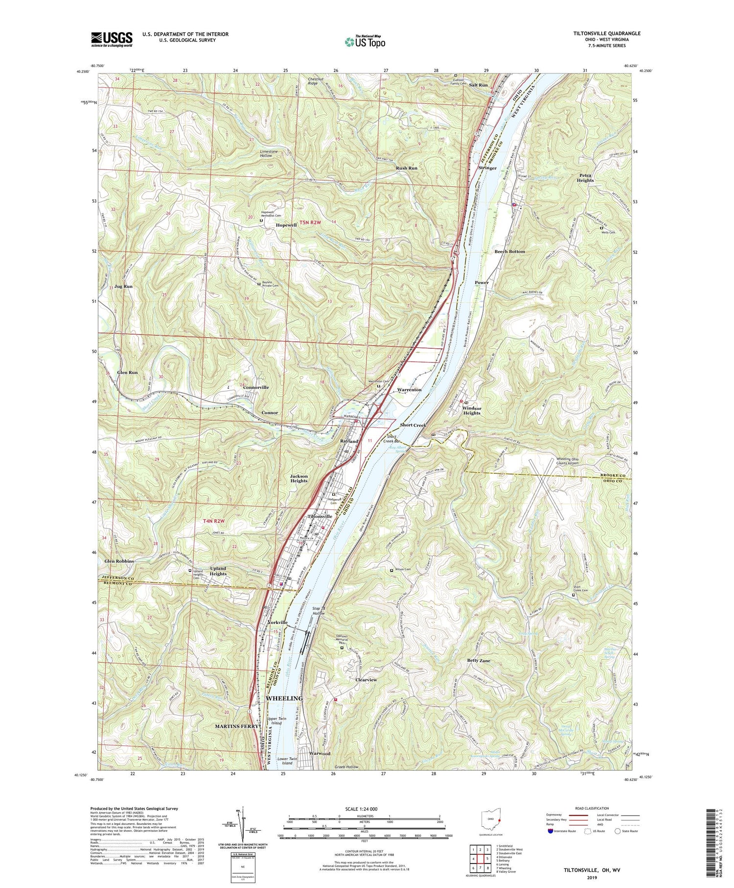
2019 topographic map quadrangle Tiltonsville in the states of Ohio, West Virginia. Scale: 1:24000. Based on the newly updated USGS 7.5' US Topo map series, this map is in the following counties: Jefferson, Ohio, Brooke, Belmont. The map contains contour data, water features, and other items you are used to seeing on USGS maps, but also has updated roads and other features. This is the next generation of topographic maps. Printed on high-quality waterproof paper with UV fade-resistant inks.
Quads adjacent to this one:
West: Dillonvale
Northwest: Smithfield
North: Steubenville West
East: Bethany
Southeast: Valley Grove
South: Wheeling
Southwest: Lansing
Contains the following named places: Bayless Private Cemetery, Beech Bottom, Beech Bottom Bar, Beech Bottom Community Church, Beech Bottom Police Department, Beech Bottom Post Office, Beech Bottom Primary School, Beech Bottom Volunteer Fire Department, Betty Zane, Blues Run, Bowman, Brooke County Home, Chapel Hill Church, Clearview, Clearview Police Department, Clearview Volunteer Fire Department, Connor, Connorville, Connorville Census Designated Place, Connorville Post Office, Debo Park Speedway, Deep Run, Everson Family Cemetery, Girty Run, Glen Robbins, Glen Robbins Post Office, Glen Run, Glenndale, Graeb Hollow, Grandview Heights, Gray Spring, Hammond School, Highland City, Hill School, Hodgens Cemetery, Holy Family Roman Catholic Church, Hopewell, Hopewell Methodist Cemetery, Hopewell Methodist Church, Huff Run, Indian Mound Cemetery, Jackson Heights, Jug Run, Julian Kowczynski Spring, Kadesh Chapel, Lawrencefield Chapel, Limestone Hollow, Limestone Run, Little Rush Run, Little Short Creek, Lock and Dam Number 11, Lower Twin Island, Martha Schell Spring, Mazeroski Park, Memorial Park, Newlands Run, North Fork Short Creek, Oaklawn Memorial Park, Orval McCardle Spring, Patton Run, Pettit Heights, Pike Island Locks and Dam, Pike Island Pool, Plummer Field, Power, Ray Albert Spring, Rayland, Rayland Post Office, Rayland Volunteer Fire Department Station 56, Rush Run, Rush Run Chapel, Rush Run Church, Rush Run Post Office, Saint Josephs School, Salt Run, Shannon, Short Creek, Short Creek Bar, Short Creek Cemetery, Short Creek Post Office, Short Creek Speedway, Short Creek United Methodist Church, South Middle School, Souttell Run, Spring Run, Stamp Spring, Stop 28 Hollow, Stringer, Tiltonsville, Tiltonsville Elementary School, Tiltonsville Post Office, Tiltonsville Volunteer Fire Department, Township of Warren, Upland Heights, Upland Heights Cemetery, Upper Twin Island, Village of Beech Bottom, Village of Clearview, Village of Rayland, Village of Tiltonsville, Village of Windsor Heights, Village of Yorkville, Vine Cliff Golf Course, Waddles Run, Warren High School, Warrenton, Warrenton Cemetery, Warrenton Post Office, Wells Cemetery, Wells School, Wheeling Ohio County Airport, Williamson Run, Willow Springs, Wilson, Wilson Cemetery, Windsor Heights, Windsor Heights Post Office, Windsor Heights School, Windsor Heights Volunteer Fire Department, Windsor Mine, Yorkville, Yorkville Police Department, Yorkville Post Office, Yorkville School, Yorkville Volunteer Fire Department, ZIP Codes: 26030, 26075, 43943, 43963, 43971