MyTopo
Withamsville Ohio US Topo Map
Couldn't load pickup availability
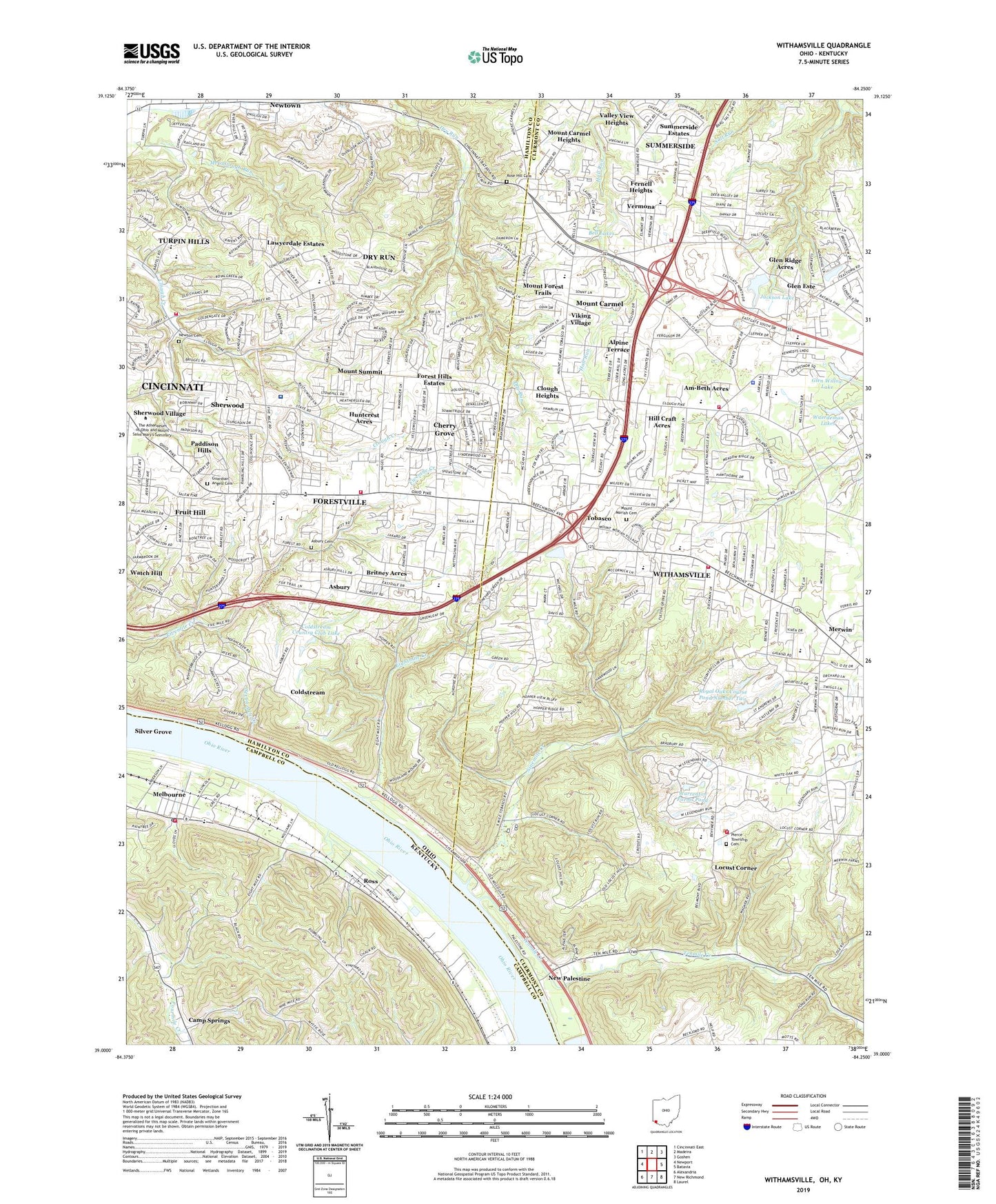
2019 topographic map quadrangle Withamsville in the states of Ohio, Kentucky. Scale: 1:24000. Based on the newly updated USGS 7.5' US Topo map series, this map is in the following counties: Clermont, Hamilton, Campbell. The map contains contour data, water features, and other items you are used to seeing on USGS maps, but also has updated roads and other features. This is the next generation of topographic maps. Printed on high-quality waterproof paper with UV fade-resistant inks.
Quads adjacent to this one:
West: Newport
Northwest: Cincinnati East
North: Madeira
Northeast: Goshen
East: Batavia
Southeast: Laurel
South: New Richmond
Southwest: Alexandria
Contains the following named places: All Saints Lutheran Church, Alp Memorial Park, Alpine Terrace, Am-Beth Acres, Anderson High School, Anderson Office Park, Anderson Post Office, Anderson Township Fire and Rescue Department Station 101, Anderson Township Fire and Rescue Department Station 6, Asbury, Asbury Cemetery, Asbury Post Office, Ayer Elementary School, Beech Acres Orphanage, Beechmont Mall Shopping Center, Beechmont Plaza Shopping Center, Beechmont Station Shopping Center, Bell Lakes, Beulah Lake, Biggs Shopping Center, Brantner Elementary School, Britney Acres, Brown Stadium, Calvary Chapel, Camp Springs, Cherry Grove, Cherry Grove Census Designated Place, Cherry Grove Plaza Shopping Center, Cherry Grove Post Office, City of Melbourne, Clepper Park, Clermont County Industrial Park, Clermont Water Treatment Plant, Clough Church, Clough Heights, Clough Pike Church, Clough Pike Elementary School, Coldstream Census Designated Place, Coldstream Country Club, Coldstream Country Club Lake, Coldstream Country Club Lake Dam, Crossings of Anderson Shopping Center, Dry Run, Dry Run Census Designated Place, Eastgate Commerce Center, Eastgate Mall Shopping Center, Eastgate Pavillion, Eastgate Square Shopping Center, Eightmile, Eightmile Creek, Eightmile Post Office, Eightmile School, Ellenora, Ellenora Post Office, Executive Center East, Faith United Church of Christ, Fernell Heights, First Baptist Church of Gleneste, First Church of Christ Scientist, Fivemile Chapel, Fivemile School, Forest Hills Estates, Forest Road Park, Forestville, Forestville Census Designated Place, Forestville Post Office, Fruit Hill, Fruit Hill Census Designated Place, Fruithill Post Office, Glen Este, Glen Este High School, Glen Este Junior High School, Glen Este Post Office, Glen Ridge Acres, Glen Ridge Lake Dam, Glen Willow Lake, Guardian Angels Cemetery, Hill Craft Acres, Home, Huntcrest Acres, Immaculate Heart of Mary School, Jackson Lake, Lawyerdale Estates, Legendary Run Golf Course, Locust Corner, Locust Corner Post Office, Locust Corner United Methodist Church, Maddux Elementary School, Martz Playgrounds, Mays Heliport, Medcorp Emergency Medical Services, Melbourne, Melbourne Post Office, Melbourne Volunteer Fire Department, Melburne Railroad Station, Mercer Elementary School, Mercy Hospital Anderson, Merwin, Merwin Elementary School, Merwin Post Office, Mount Carmel, Mount Carmel Assembly of God Church, Mount Carmel Census Designated Place, Mount Carmel Heights, Mount Carmel Park, Mount Carmel Post Office, Mount Carmel Station, Mount Forest Trails, Mount Moriah Cemetery, Mount Moriah United Methodist Church, Mount Summit, Mount Summit Post Office, Mount Washington Church of Christ, Nagel Road Park, New Palestine, New Palestine Post Office, Newton Cemetery, Newtown, Newtown Post Office, Ninemile, Ninemile Creek, Ninemile Post Office, Ninemile School, Oak Tree Shopping Center, Old Pathway Church, Paddison Hills, Park Plaza Shopping Center, Pierce Elementary School, Pierce Township Cemetery, Pierce Township Fire Department Station 44, Pierce Township Hall, Pierce Township Nature Area, Pierce Township Park, Pierce Township Police Station, Plainview School, Pleasant Valley School, Rose Hill Cemetery, Ross, Ross Post Office, Ross Railroad Station, Royal Oak Country Club, Royal Oak Golf Course, Royal Oaks Course Pond Number Two, Royal Oaks Golf Course Pond Number One, Sacred Heart Seminary, Saint Gregorys Seminary, Saint John Fisher Roman Catholic Church, Saint Thomas More Catholic Church, Saint Thomas More Elementary School, Saint Veronica Catholic Church, Saint Veronica Elementary School, Seven Mile Creek, Shady Lane Boat Harbor, Sherwood, Sherwood Census Designated Place, Sherwood Elementary School, Sherwood Village, Spann, Spann Post Office, Summerside, Summerside Census Designated Place, Summerside Elementary School, Summerside Estates, Summerside Post Office, Summerside United Methodist Church, Summit Elementary School, Symmes Post Office, Tenmile Creek, Tenmile Station, Tobasco, Tobasco Post Office, Township of Anderson, Township of Pierce, Township of Union, Turpin High School, Turpin Hills Census Designated Place, Union Township Fire Department Station 48, Union Township Fire Department Station 49, Union Township Fire Station 51, Union Township Library, Union Township Police Department, Upper Ninemile School, Valley View Heights, Vermona, Veterans Park, Viking Village, Village of Newtown, Vineyard Golf Course, Vineyards Golf Course, Warrenton Farms Dam, Warrenton Farms Pond, Watch Hill, White Lake, Whiteoak School, Wilson Elementary School, Withamsville, Withamsville Census Designated Place, Withamsville Church of Christ, Withamsville Post Office, Withamsville-Tobasco Elementary School, Withamsville-Tobasco Park, WRBZ-FM (Milford), Wuerdeman Lakes, ZIP Codes: 41059, 45244, 45245, 45255