MyTopo
Newport Kentucky US Topo Map
Couldn't load pickup availability
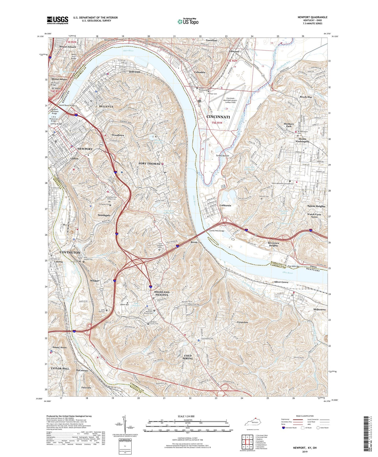
2022 topographic map quadrangle Newport in the states of Kentucky, Ohio. Scale: 1:24000. Based on the newly updated USGS 7.5' US Topo map series, this map is in the following counties: Campbell, Hamilton, Kenton. The map contains contour data, water features, and other items you are used to seeing on USGS maps, but also has updated roads and other features. This is the next generation of topographic maps. Printed on high-quality waterproof paper with UV fade-resistant inks.
Quads adjacent to this one:
West: Covington
Northwest: Cincinnati West
North: Cincinnati East
Northeast: Madeira
East: Withamsville
Southeast: New Richmond
South: Alexandria
Southwest: Independence
Contains the following named places: Adams Marina, Airport Playfield, Albright Health Center, Alms Park, Alums Park, Anderson D Owens Elementary School, Anderson Park, Apple Hill Farm Lake, Apple Hill Farm Lake Dam, Arnold Elementary School, Asbury Methodist Church Cemetery, Authors Grove, Banklick Creek, Beech-Mar, Beechview Estates, Bellevue, Bellevue Grade School, Bellevue High School, Brent, Brent Railroad Station, Bridgeview Harbor, California, California Day Camp, California Golf Course, California Station, California Woods Natural Preserve, California Yacht Club, Camp Springs School, Campbell County Cemetery, Campbell County Health Center, Chatfield Memorial, Cincinnati Municipal Airport-Lunken Field, Cincinnati Waterworks, City of Bellevue, City of Cold Spring, City of Crestview, City of Dayton, City of Fort Thomas, City of Highland Heights, City of Newport, City of Silver Grove, City of Southgate, City of Taylor Mill, City of Wilder, City of Woodlawn, Clifton, Clough Creek, Coal Haven, Cold Spring, Cold Spring Industrial Park, Columbia, Combs-Hehl Bridge, Coney Railroad Station, Corpus Christi Cemetery, Corpus Christi School, Cote Brilliant, Covington Filtration Plant, Covington Reservoirs, Crestview, Dale School, Daniel Beard Bridge, Dayton, Dayton High School, Dayton Railroad Station, DeCoursey, DeCoursey Creek, DeCoursey Railroad Station, DeCoursey Railroad Yard, District School Number 14, Dodsworth Lane, Duck Creek, East End Park, Eden Park, Eden Park Overlook, Evergreen Cemetery, Evergreen Cemetery Soldiers' Lot, Ferry Street Park, Five Mile Bar, Fivemile Creek, Fort Thomas, Four Seasons Marina, Fourmile Creek, Fourmile Lake, Fourmile Lake Dam, Fourteenth District School, Fourth Street Elementary School, Frank Ignatius Grein Softball Field, Friendship Field, Fulton, Fulton - Presbyterian Cemetery, Gilbert-Sinton Historic District, Grandview Elementary School, Grandview School, Heros Grove, Highland Country Club, Highland Heights, Highland Hills Park, Highlands High School, Hillcrest Cemetery, Horizon Heliport, Horizons Heliport, Ida Street Bridge, Idlewile Marina, Immaculate Conception School, Johns Hill, Johns Hill Cemetery, Johnson School, Johnston Park, Kellogg Avenue Park, L & N Pedestrian Bridge, Lake Inferior, Lake Louise, Lake Louise Dam, Landrum Academic Center, Latonia Elementary School, Leblond Park, Lincoln Elementary School, Linwood Park, Little Miami River, Little Miami River Park and Recreation Area, Little Miami Wastewater Treatment Plant, McCullough Run, Melan Arch Bridge, Miami Beach Marina, Midwest Communication Heliport, Mildred Dean Elementary School, Miller Treatment Plant, Mirror Lake, Mount Adams, Mount Adams Playground, Mount Pleasant School, Mount Saint Martin's Young Women's Institute, Mount Vernon School, Mount Washington, Mount Washington Cemetery, Moyer Elementary School, Newport, Newport Academy, Newport Central Catholic High School, Newport High School, Newport Middle School, Newport Plaza Shopping Center, Newport Reservoir, Newport Southbank Bridge, Newport-Fort Thomas Division, Ninth Street Public School, Northern Kentucky University, Notre Dame School, Old Coney Amusement Park, Our Lady of the Highlands School for Girls, Owl Creek, Park Avenue School, Pendleton, Pioneer Cemetery, Pooles Creek, Pools Creek, Queen City Yacht Club, Rakestraw Memorial Field, Reeses Settlement, Reeves Golf Course, River Downs Racetrack, Riverview Drive-In, Riverview Heights, Riverview Park, Rosedale Park, Rossford, Royal Oaks Park, Sacred Heart Catholic School, Sacred Heart School, Saint Anthonys School, Saint Bernard School, Saint Catherine Siena School, Saint Francis And Holy Trinity Junior High School, Saint Josephs Cemetery, Saint Josephs School, Saint Luke Hospital Heliport, Saint Stephen School, Saint Stephens Cemetery, Saint Therese School, Saint Thomas School, Saint Vincent De Paul School, Salem Heights, Salem Heights Census Designated Place, Salem Methodist Episcopal Cemetery, Sawyer Point Park, Select Specialty Hospital, Shortway Bridge, Silver Grove, Southgate, Southgate Public School, Speers Memorial Hospital, Spring Lake School, Stanberry Park, Stanbery Park, Stevens Railroad Station, Stevens Railroad Yard, Sunny Acres, Sweetwine, Tacoma Park, Tenth District School, The Estates At Wiedemann Mansion, Theodore M Berry International Friendship Park, Threemile Creek, Tug Creek, Tug Fork, Turkey Bottom, Turkey Ridge Park, Turpin Hills, Tusculum, Twin Oaks Golf and Plantation Club, Uhl Creek, Walker Park, Walnut Hills Academy, Washington Marina, Watch Farm Acres, Wewes Boat Harbor, Wilder, Willison Landing, Winston Hills, Winters Lane, Withrow Nature Preserve, WNKU-FM (Highland Heights), Wolking Lake, Woodfill Elementary School, Woodlawn, Yacht Haven Marina, ZIP Codes: 41071, 41073, 41074, 41075, 41076, 41085, 41099, 45226, 45230