MyTopo
Alexandria Kentucky US Topo Map
Couldn't load pickup availability
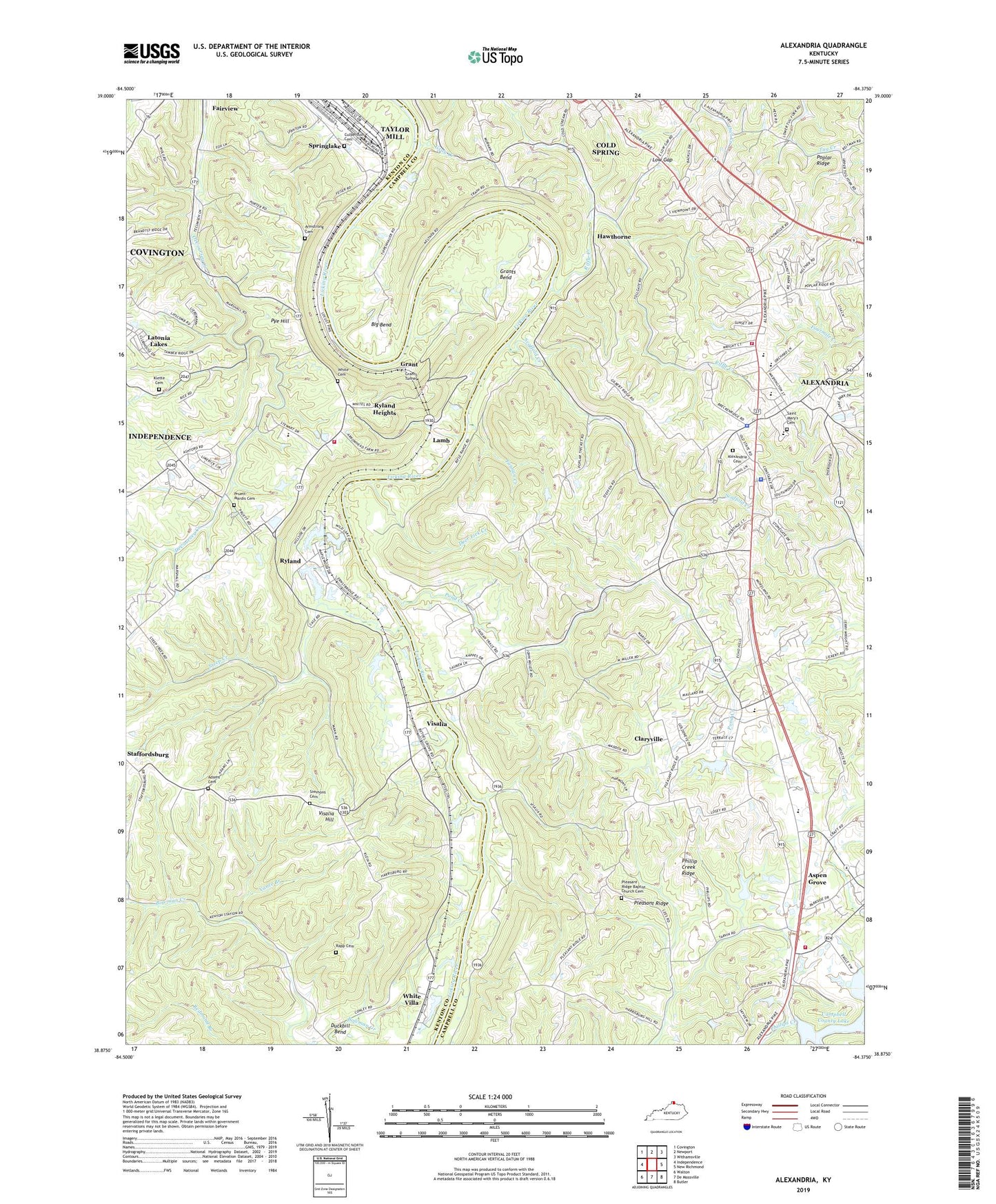
2022 topographic map quadrangle Alexandria in the state of Kentucky. Scale: 1:24000. Based on the newly updated USGS 7.5' US Topo map series, this map is in the following counties: Campbell, Kenton. The map contains contour data, water features, and other items you are used to seeing on USGS maps, but also has updated roads and other features. This is the next generation of topographic maps. Printed on high-quality waterproof paper with UV fade-resistant inks.
Quads adjacent to this one:
West: Independence
Northwest: Covington
North: Newport
Northeast: Withamsville
East: New Richmond
Southeast: Butler
South: De Mossville
Southwest: Walton
This map covers the same area as the classic USGS quad with code o38084h4.
Contains the following named places: Adams Cemetery, Alexandria, Alexandria Cemetery, Alexandria Church of Christ, Alexandria Division, Alexandria Fairgrounds, Alexandria Fire District, Alexandria Police Department, Alexandria Post Office, Alexandria United Methodist Church, Armstrong Cemetery, Aspen Grove, Aspen Grove Church, Aspen Grove School, Barry Post Office, Big Bend, Bird Wood Post Office, Bowman Creek, Campbell County, Campbell County Police Department, Campbell County Poorhouse, City of Alexandria, City of Fairview, City of Latonia Lakes, City of Ryland Heights, Claryville, Claryville Census Designated Place, Claryville Post Office, Claryville School, Culbertson Cemetery, Deer Lick Creek, Duckbill Bend, Fairview, Fannan Creek, First Baptist Church, Grant, Grant Railroad Station, Grants Bend, Grants Bend Post Office, Grants Tunnel, Gray Creek, Gray Hill School, Hawthorne, Hawthorne Post Office, Hawthorne School, Holmes Ferry, John Grants Mill, Kees Park, Klette Cemetery, Lamb, Lamb Railroad Station, Lambs Ferry, Latonia Lakes, Licking Valley Baptist Church, Locust Railroad Station, Low Gap, Main Street Baptist Church, McCormick Vocational School, McGill Post Office, McVean Post Office, Mills Road Park, Morris Chapel Methodist Episcopal Church, Nathaniel Vises Ferry, New Canton Post Office, New Canton Railroad Station, New Macedonia Baptist Church, Oaklawn Railroad Station, Phillip Creek Ridge, Pie Railroad Station, Pleasant Ridge, Pleasant Ridge Baptist Church, Pleasant Ridge Baptist Church Cemetery, Pleasant Ridge School, Pond Creek, Pond Creek School, Poplar Ridge, Poplar Ridge School, Poplar Thicket, Pruett - Mardis Cemetery, Pruett Post Office, Pye, Pye Hill, Rapp Cemetery, Riffle Creek, Ryland, Ryland Heights, Ryland Heights and Community Life Squad, Ryland Heights Fire and Emergency Management Services, Ryland Heights School, Ryland Lakes Golf Course, Ryland Post Office, Ryland Railroad Station, Saint Mary School, Saint Mary's Catholic Church, Saint Mary's Cemetery, Saint Matthew Church, Saint Matthews School, Saint Paul's United Church of Christ, Salisbury, Scaffold Creek, School Number Fifty, Simmons Cemetery, Southern Campbell Fire District, Springdale, Springlake, Springlake Railroad Station, Stanfordburg School, Steep Creek, Sunnypoint Railroad Station, Taylor Mill, Tenmile House, Tenmile Post Office, Vance Branch, Visalia, Visalia Elementary School, Visalia Hill, Visalia Hill School, Visalia Post Office, Visalia Railroad Station, Visalia School, White Cemetery, White Villa, White Villa Railroad Station, Winston Railroad Station, ZIP Codes: 41001, 41015