MyTopo
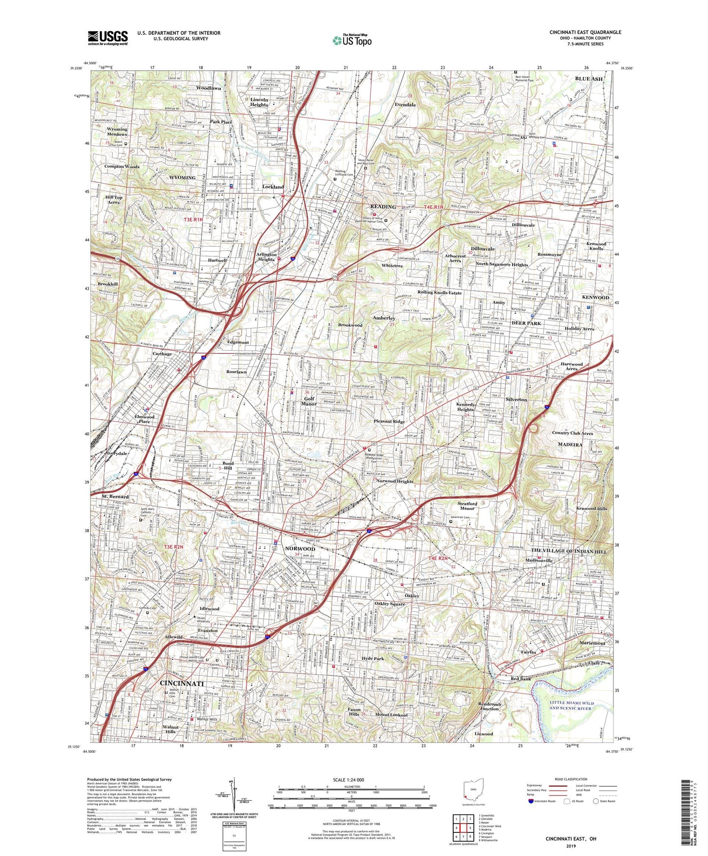
Cincinnati East Ohio US Topo Map
Couldn't load pickup availability
2023 topographic map quadrangle Cincinnati East in the state of Ohio. Scale: 1:24000. Based on the newly updated USGS 7.5' US Topo map series, this map is in the following counties: Hamilton. The map contains contour data, water features, and other items you are used to seeing on USGS maps, but also has updated roads and other features. This is the next generation of topographic maps. Printed on high-quality waterproof paper with UV fade-resistant inks.
Quads adjacent to this one:
West: Cincinnati West
Northwest: Greenhills
North: Glendale
Northeast: Mason
East: Madeira
Southeast: Withamsville
South: Newport
Southwest: Covington
This map covers the same area as the classic USGS quad with code o39084b4.
Contains the following named places: Amberley, American Cemetery, Amity, Annwood Park, Arbocrest Acres, Arlington Heights, Ault Park, Avon Field, Avondale, Avondale Town Center Shopping Center, Beech Grove Cemetery, Beechwood, Bethesda Hospital, Blue Ash, Blue Ash Commons Shopping Center, Blue Ash Golf Course, Blue Ash Recreation Center, Blue Ash Shopping Center, Bond Hill, Bond Hill Park, Booth Hospital, Bramble Park, Brookhill, Brookwood, Burwood Playground, Caldwell Park, Calvary Cemetery, Carthage, Centennial Park, Chamberlin Park, Cincinnati Country Club, City of Blue Ash, City of Deer Park, City of Norwood, City of Reading, City of Wyoming, Clare, Compton Woods, Congress Run, Corcoran Field, Country Club Acres, Crest Hills Country Club, Crossings of Blue Ash Shopping Center, Dale Park, Dallmans Corner, Dar Field, Deer Park, Dillionvale, Dillonvale, Dillonvale Census Designated Place, Dillonvale Shopping Center, Dogwood Park, Dorl Field, Drake Park, East Madisonville, Edgemont, Elmwood Place, Elmwood Place Memorial Park, Emery Carillon, Evanston, Evanston Playground, Fairfax, Faxon Hills, Fenwick Park, Fleischmann Gardens, French Park, German Cemetery, Getwell Hospital, Gold Circle Mall Shopping Center, Golf Manor, Gorman Heritage Farm, Hamilton County Fairgrounds, Hamilton County Infirmary, Harewood Acres, Hartwell, Hartwell Country Club, Hauck Botanic Gardens, Hayden Field, Highland Ridge Shopping Center, Hill Top Acres, Hillcrest Shopping Mall Shopping Center, Hoffman Playground, Holiday Acres, Hoyes Field, Hunter Park, Hunters Plaza Shopping Center, Hyde Park, Hyde Park Country Club, Hyde Park Shopping Center, Hyde Park Square, Idlewild, Idlewood, Indian Hill, Ivorydale, Jewish Community Center, Jewish Hospital, Kennedy Heights, Kennedy Heights Park, Kennedy Station, Kenwood Census Designated Place, Kenwood Country Club, Kenwood Hills, Kenwood Knolls, Kenwood Mall Shopping Center, Kenwood Towne Centre Shopping Center, Koening Park, Laurel Cemetery, Lincoln Heights, Linwood, Little Duck Creek Park, Lockland, Lockland Commerce Park, Longview State Hospital, Losantiville Country Club, Lyons Corporate Center, M L King Junior Park, Madison and Woodburn Historic District, Madison Park, Madison Place Census Designated Place, Madison-Stewart Historic District, Madisonville, Maketewah Country Club, Mariemont Gardens Park, Mariemont Municipal Swimming Pool, Marsh Avenue Park, Millcreek Psychiatric Center for Children, Millcrest Park, Mitchell Triangle, Mount Lookout, North Sagamore Heights, Norwood, Norwood Heights, Norwood Industrial Park, Norwood Plaza Shopping Center, Norwood Waterworks, Oaklawn Industrial Park, Oakley, Oakley Playground, Oakley Square, O'Brien Terrace, O'Bryonsville, Observatory Historic District, Owls Nest Park, Park Place, Peebles Corner, Peebles Corner Historic District, Plainfield Cemetery, Pleasant Ridge, Pleasant Ridge Park, Pleasant Ridge Presbyterian Cemetery, Reading, Reading Lockland Cemetery, Red Bank, Rendcomb Junction, Ridgewood Census Designated Place, Ridgewood Golf Course, Roettger Field, Rolling Knolls Estate, Roselawn, Roselawn Park, Ross Avenue Park, Rossmoyne, Rossmoyne Census Designated Place, Saint Anthony Cemetery, Saint Bernard, Saint Bernard Square Shopping Center, Saint Francis De Sales Church Historic District, Saint Josephs Infant Home and Maternity Hospital, Saint Mary Cemetery, Saints Peter and Paul Cemetery, Scarborough Woods, Seasongoer Square, Seymour Nature Preserve, Seymour Plaza Shopping Center, Silverton, Silverton Field, Sisters of Notre Dame Cemetery, Stella Park, Stratford Manor, Summit Plaza Shopping Center, Surrey Square Mall Shopping Center, Swifton Shopping Center, The Orchard Office Park, Tower Park, Township of Sycamore, Twin Drive-In, United Jewish Cemetery - Walnut Hills, University of Cincinnati Observatory, Valley Shopping Center, Valleydale, Victory Park, Village Historic District, Village of Amberley, Village of Arlington Heights, Village of Elmwood Place, Village of Fairfax, Village of Golf Manor, Village of Lincoln Heights, Village of Lockland, Village of Mariemont, Village of Saint Bernard, Village of Silverton, Voorhees Park, WAIF-FM (Cincinnati), Walnut Hills, Walnut Hills Cemetery, Walnut Hills-Evanston Medical Center, Waterworks Park, WCPO-TV (Cincinnati), WEBN-FM (Cincinnati), West Fork Mill Creek, Whitetree, Woodburn, Woodford Park, Woodward Park, WUBE-FM (Cincinnati), Wulsin Triangle, WVXU-FM (Cincinnati), Wyoming, Wyoming Golf Club, Wyoming Meadows, Wyoming Park, ZIP Codes: 45206, 45207, 45208, 45209, 45212, 45213, 45215, 45216, 45217, 45227, 45229, 45236, 45237