MyTopo
Oklahoma City SE Oklahoma US Topo Map
Couldn't load pickup availability
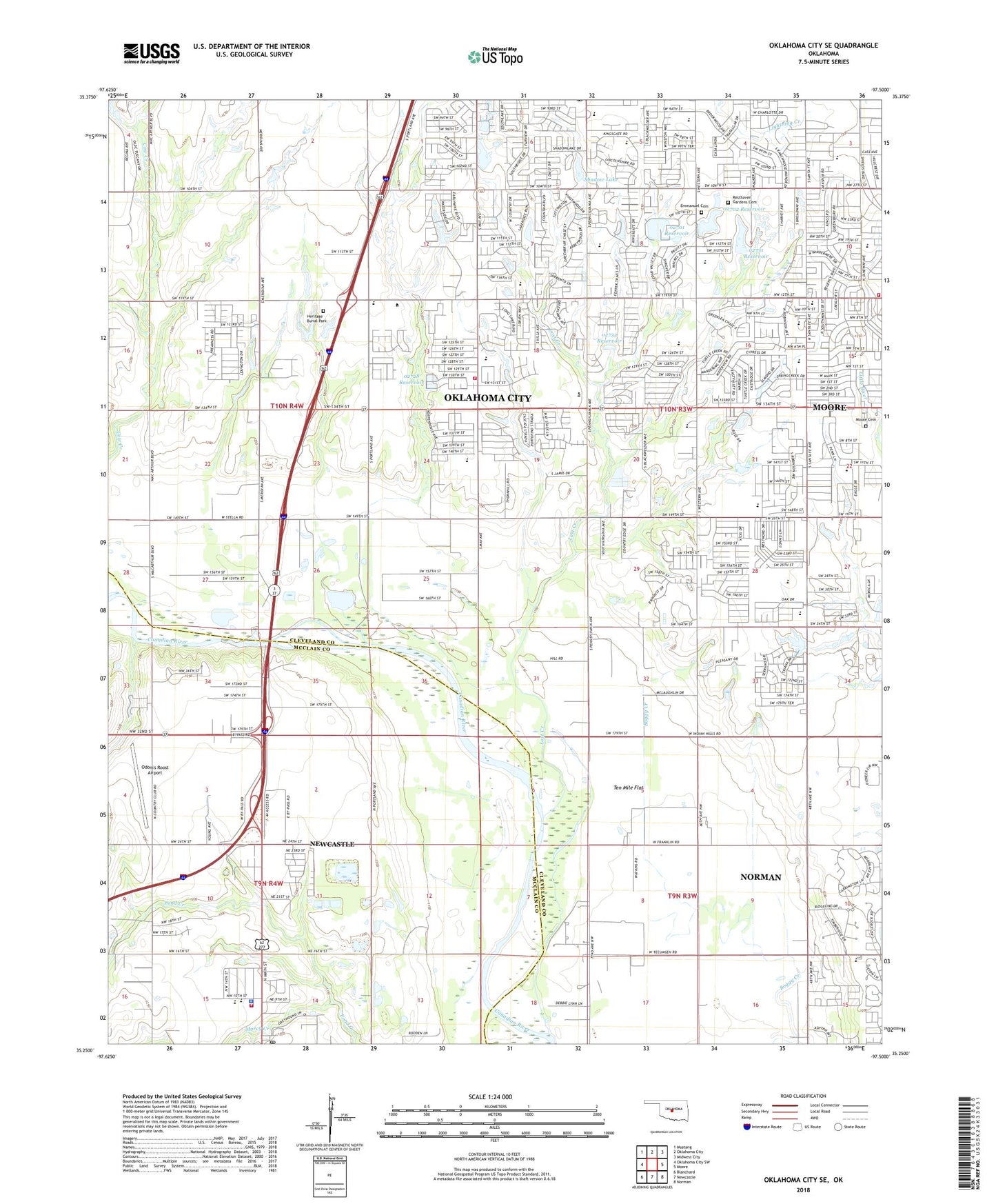
2018 topographic map quadrangle Oklahoma City SE in the state of Oklahoma. Scale: 1:24000. Based on the newly updated USGS 7.5' US Topo map series, this map is in the following counties: Cleveland, McClain. The map contains contour data, water features, and other items you are used to seeing on USGS maps, but also has updated roads and other features. This is the next generation of topographic maps. Printed on high-quality waterproof paper with UV fade-resistant inks.
Quads adjacent to this one:
West: Oklahoma City SW
Northwest: Mustang
North: Oklahoma City
Northeast: Midwest City
East: Moore
Southeast: Norman
South: Newcastle
Southwest: Blanchard
Contains the following named places: Alliance Bible Church, Antioch Christian Academy, Antioch Christian Church, Antioch Church, Appletree Square, Baptist Childrens Home, Beth Haven Independent Baptist Church, Briarwood Elementary School, Brink Junior High School, Calvary Brethren in Christ Church, Capitol Hill Baptist Church South, Capitol Hill Full Gospel Church, Christian Life Fellowship Church, Church of God of Prophesy, Church of the Holy Apostles, Community Cupboard Church, Earlywine Church, Earlywine Elementary School, Earlywine Park, Eastlake Elementary School, Emmanuel Cemetery, Emmaus Church, First Baptist Church, First Baptist Church of Newcastle, Fisher Elementary School, Good Shepherd Christian Church, Graceway Baptist Church, Greenway Plaza, Heritage Burial Park, High Praise Church, Highland West Junior High School, Holy Cross Lutheran Church, Houchin Elementary School, Jesus Alive Evangelistic Church, Kelley Elementary School, Kingdom Hall of Jehovahs Witnesses-Moore, Kingsgate Elementary School, Kingspark Baptist Church, Kingsview Freewill Baptist Church, KOMA-AM (Oklahoma City), Lightning Creek Holding Pond A, Lightning Creek Holding Pond A Dam, Lost Creek, Malibu Shopping Center, Meadowbrook School, Mid - America Christian University, Moore Cemetery, Moore Church of God, Moore Fire Department Station 2, New Beginning Fellowship Church, Newcastle Elementary School, Newcastle Fire Department Station 1, Newcastle Police Department, Newcastle Post Office, Odom's Roost Airport, Oklahoma Chinese Baptist Church, Oklahoma City Fire Department Station 35, Oknoname 02701 Dam, Oknoname 02701 Reservoir, Oknoname 02702 Dam, Oknoname 02702 Reservoir, Oknoname 02728 Dam, Oknoname 02728 Reservoir, Oknoname 02731 Dam, Oknoname 02731 Reservoir, Oknoname 02732 Dam, Oknoname 02732 Reservoir, Plaza Towers Elementary School, Pleasant Valley School, Red Oak Elementary School, Regency Park Baptist Church, Resthaven Gardens Cemetery, Revival for Christ Club Incorporated Church, Rock Assembly of God, Roosevelt Elementary School, Saint Andrews Catholic Church, Saint Johns Lutheran Church, Saint John's Lutheran School, Saint Mark the Evangelist Church, Santa Fe Elementary School, Shadow Dam, Shadow Lake, Sharon Baptist Church, Shartel Church of God, Shekinah Fellowship Church, Sky Ranch Elementary School, Sky Ranch Park, Southgate - Rippetoe Elementary School, Southgate Baptist Church, Southmoore High School, Southpark Baptist Church, Southside Church, Southwest Christian Academy, Southwestern Plaza, Tabernacle of Praise, Temple Baptist Church, Ten Mile Flat, The Church of Jesus Christ of Latter Day Saints, Township of Liberty, Township of Taylor, Tri-City, United Pentecostal Church, Wayland Bonds Elementary School, West Junior High School, Westminster Village Shopping Center, Westmoore High School, Westmore Baptist Church, WWLS-AM (Moore), ZIP Codes: 73065, 73170