
MyTopo
Ponca City Oklahoma US Topo Map
Couldn't load pickup availability
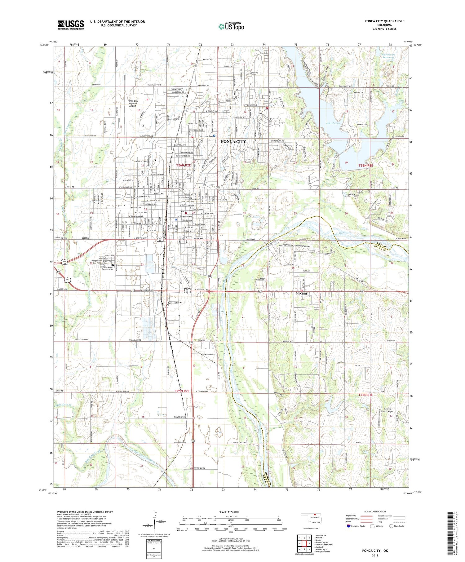
2018 topographic map quadrangle Ponca City in the state of Oklahoma. Scale: 1:24000. Based on the newly updated USGS 7.5' US Topo map series, this map is in the following counties: Kay, Osage. The map contains contour data, water features, and other items you are used to seeing on USGS maps, but also has updated roads and other features. This is the next generation of topographic maps. Printed on high-quality waterproof paper with UV fade-resistant inks.
Quads adjacent to this one:
West: Ponca City NW
Northwest: Newkirk SW
North: Kildare
Northeast: Uncas
East: Charley Creek West
Southeast: Prettyhair Creek
South: Ponca City SE
Southwest: Marland
Contains the following named places: Airline Drive-In, Albright United Methodist Church, Alliance Health Ponca City, Asbury United Methodist Church, Assumption High School, Believers Fellowship Church, Bible Baptist Church, Big Bend Oil Field, Blaine Stadium, Bois d'Arc Creek, Central Baptist Church, Christian Center, Church of Christ Broadway, Church of Christ Hartford Avenue, City of Ponca City, Community Christian Church, E M Trout Elementary School, East Cattle Creek, East Lake Ponca, East Middle School, Ernest Whitworth Marland Mansion, Evangel Christian Fellowship Church, First Assembly of God, First Baptist Church, First Church of God, First Church of the Nazarene, First Lutheran Church, First Lutheran School, First Pentecostal Holiness Church, First United Pentecostal Church, Frazier Park, Garfield Elementary School, Garfield Park, Grace Episcopal Church, Harmony Missionary Baptist Church, Hartford Shopping Center, Hartford Square Shopping Center, Jefferson School, Kingdom Hall Jehovahs Witnesses, KPNC-FM (Ponca City), Lake Ponca, Lake Ponca Park, Legion School, Liberty Elementary School, Lincoln Elementary School, McCord, McCord Census Designated Place, McCord Community Volunteer Fire Department, McCord Elementary School, McKinley School, Morgan Park, Nazarene Trinity Church, New Creation Church, New Life Pentecostal Church, North Park, Northeast Baptist Church, Pecan Park, Pioneer Bible Church, Pioneer Shopping Center, Pioneer Technology Center, Pioneer Woman Monument, Ponca Church, Ponca City, Ponca City Beauty College, Ponca City Christian Academy, Ponca City Division, Ponca City Fire Department Station 1, Ponca City Fire Department Station 2, Ponca City Fire Department Station 3, Ponca City Fire Department Station 4, Ponca City High School, Ponca City Independent Order of Odd Fellows Cemetery, Ponca City Kindergarten, Ponca City Police Department, Ponca City Post Office, Ponca City Regional Airport, Ponca Dam, Ponca Indian Cemetery, Ponca Military Academy, Ponca Plaza, Prince of Peace Church, Redbud Park, Roosevelt Elementary School, Saint Lukes Church-Nazarene, Saint Mary's Catholic Cemetery, Saint Marys Catholic Church, Saint Mary's Catholic School, Schrickram Dam, Schrickram Reservoir, Second Baptist Church, Secrest Ranch Airport, Sherwood Park, Southside Baptist Church, Southwest McCord Oil Field, Sunset Baptist Church, Sunset Park, Township of Cross, Trinity Pentecostal Church, Turkey Creek, Union Elementary School, War Memorial Park, Washington Elementary School, Washington School, WBBZ-AM (Ponca City), Wentz Camp, West Cattle Creek, West Grant Shopping Center, West Lake Ponca, West Middle School, White Eagle, White Eagle Census Designated Place, Woodlands Christian Church, Woodlands Elementary School, Young Park


