MyTopo
Sapulpa South Oklahoma US Topo Map
Couldn't load pickup availability
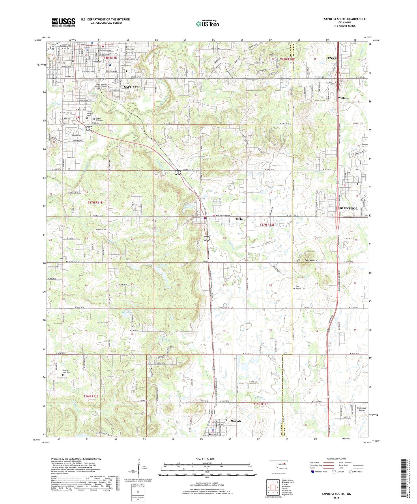
2018 topographic map quadrangle Sapulpa South in the state of Oklahoma. Scale: 1:24000. Based on the newly updated USGS 7.5' US Topo map series, this map is in the following counties: Creek, Tulsa. The map contains contour data, water features, and other items you are used to seeing on USGS maps, but also has updated roads and other features. This is the next generation of topographic maps. Printed on high-quality waterproof paper with UV fade-resistant inks.
Quads adjacent to this one:
West: Kellyville
Northwest: Lake Sahoma
North: Sapulpa North
Northeast: Jenks
East: Bixby
Southeast: Spanish Peak
South: Lake Boren
Southwest: Kiefer SW
Contains the following named places: Baptist Church of Forest Hills, Bethesda Airport, Bible Baptist Church, Biven Creek, Central Oklahoma Area Vocational College, Chief Sapulpa Burying Ground, Childres Creek, Christian Renewal Church, Church of Christ, Church of the Good Shepherd, Church of the Nazarene of Sapulpa, City of Glenpool, Creek County Sheriff's Office, Curry Hospital, Duckcreek Airport, Eagle Point Christian Academy, Emmanuel Baptist Church, First Assembly of God, First Baptist Church of Sapulpa, First Presbyterian Church, First United Methodist Church, Full Gospel Baptist Church, Glenpool, Glenpool Christian Church, Glenpool Elementary School, Glenpool High School, Glenpool Middle School, Glenpool Post Office, Glenpool Volunteer Fire Department, Glenwood Assembly of God Church, Green Hill Cemetery, Harvest Chapel, Jackson Lake Dam, Jimmie Long Cemetery, June Rose Church, Kiefer, Kiefer Elementary School, Kiefer High School, Kiefer Police Department, Kiefer Post Office, Kiefer Volunteer Fire Department Station 1 Headquarters, Kiefer Volunteer Fire Department Station 2, Lighthouse Fellowship Church, Linden Street Christian Church, Lone Star School, Merrill Ranch Airport, Morris Airport, Mounds, Mounds Elementary School, Mounds Fire Department Station 2, Mounds High School, Mounds Junior High School, Mounds Police Department, Mounds Post Office, Oknoname 037071 Dam, Oknoname 037071 Reservoir, Oknoname 037072 Dam, Oknoname 037072 Reservoir, Oknoname 037073 Dam, Oknoname 037073 Reservoir, Oknoname 037074 Dam, Oknoname 037074 Reservoir, Oknoname 037075 Dam, Oknoname 037075 Reservoir, Oknoname 037076 Dam, Oknoname 037076 Reservoir, Picket Chapel, Rock Creek, Rock Creek Shopping Center, Rongey Middle School, Sacred Heart Church, Sacred Heart School, Saint John Cemetery, Saint John Sapulpa Hospital, Saint Johns Church, Salvation Army, Sapulpa, Sapulpa Division, Sapulpa Fire Department Central Station, Sapulpa Fire Department Station 3, Sapulpa High School, Sapulpa Junior High School, Sapulpa Middle School, Sapulpa Police Department, Sapulpa Post Office, Skull Creek, South Heights Assembly of God, South Heights Baptist Church, South Heights Cemetery, South Heights School, Southside Christian Church, Town of Kiefer, Township of Glenpool, Township of Mounds, Twin Mounds, Twin Mounds Pioneer Cemetery, United Pentecostal Church, Vanguard Ministries Center, Washington Elementary School, Watkins, Westside Baptist Church, Westside Freewill Baptist Church, Woodlawn Elementary School, ZIP Codes: 74033, 74041