MyTopo
Bandon Oregon US Topo Map
Couldn't load pickup availability
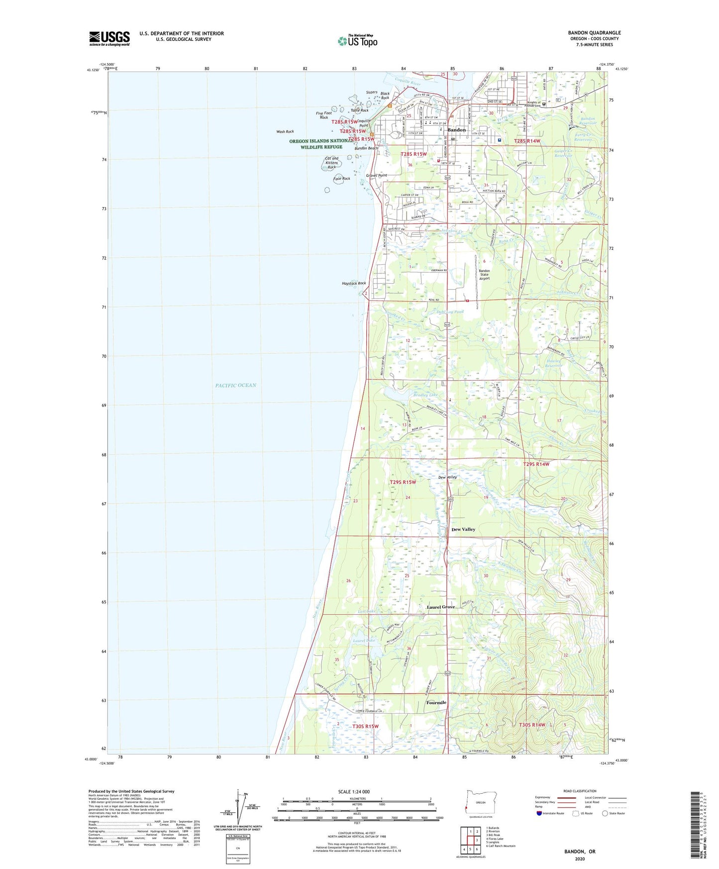
2024 topographic map quadrangle Bandon in the state of Oregon. Scale: 1:24000. Based on the newly updated USGS 7.5' US Topo map series, this map is in the following counties: Coos. The map contains contour data, water features, and other items you are used to seeing on USGS maps, but also has updated roads and other features. This is the next generation of topographic maps. Printed on high-quality waterproof paper with UV fade-resistant inks.
Quads adjacent to this one:
North: Bullards
Northeast: Riverton
East: Bill Peak
Southeast: Calf Ranch Mountain
South: Langlois
Southwest: Floras Lake
This map covers the same area as the classic USGS quad with code o43124a4.
Contains the following named places: Baker Creek, Bandon, Bandon Beach, Bandon Christian Fellowship, Bandon City Hall, Bandon Division, Bandon Historical Society Museum, Bandon Municipal Court, Bandon Police Department, Bandon Post Office, Bandon Public Library, Bandon Public Works, Bandon Reservoir, Bandon Rural Fire Protection District Kehl Station, Bandon Rural Fire Protection District Main Station, Bandon Senior High School, Bandon Sewage Treatment Plant, Bandon State Airport, Bandon State Park, Black Rock, Bradley Lake, Bradley Lake Park Boat Ramp, Brandon South Jetty County Park, Cat and Kittens Rock, China Creek, Church of Jesus Christ of Latter Day Saints, City of Bandon, City Park, Coquille Point, Coquille River, Coquille River Lighthouse, Crooked Creek, Dahl Log Pond, Devils Kitchen, Dew Valley, Dufort Creek, Face Rock, Face Rock State Park, Ferry Creek, Ferry Creek Reservoir, Five Foot Rock, Fourmile, Fourmile Creek, Fourmile Post Office, Geiger Creek, Geiger Creek Reservoir, Gravel Point, Gross Creek, Harbor Lights Middle School, Hawley Reservoir, Haystack Rock, Johnson Creek, Knights of Pythias Cemetery, Kronenberg County Park, Laurel Grove, Laurel Lake, Lost Lake, Lower Twomile Creek, Millard School, New River, New River County Park, Ocean Crest Elementary School, Port of Bandon, Port of Bandon Boat Launch, Redibaugh Creek, Rosa Creek, Sisters, South Twomile Creek, Southern Coos Hospital and Health Center, Sprague Community Theatre, Spring Creek, Table Rock, Tupper Creek, Tupper Rock, Twomile, Twomile Creek, Wash Rock