MyTopo
Garibaldi Oregon US Topo Map
Couldn't load pickup availability
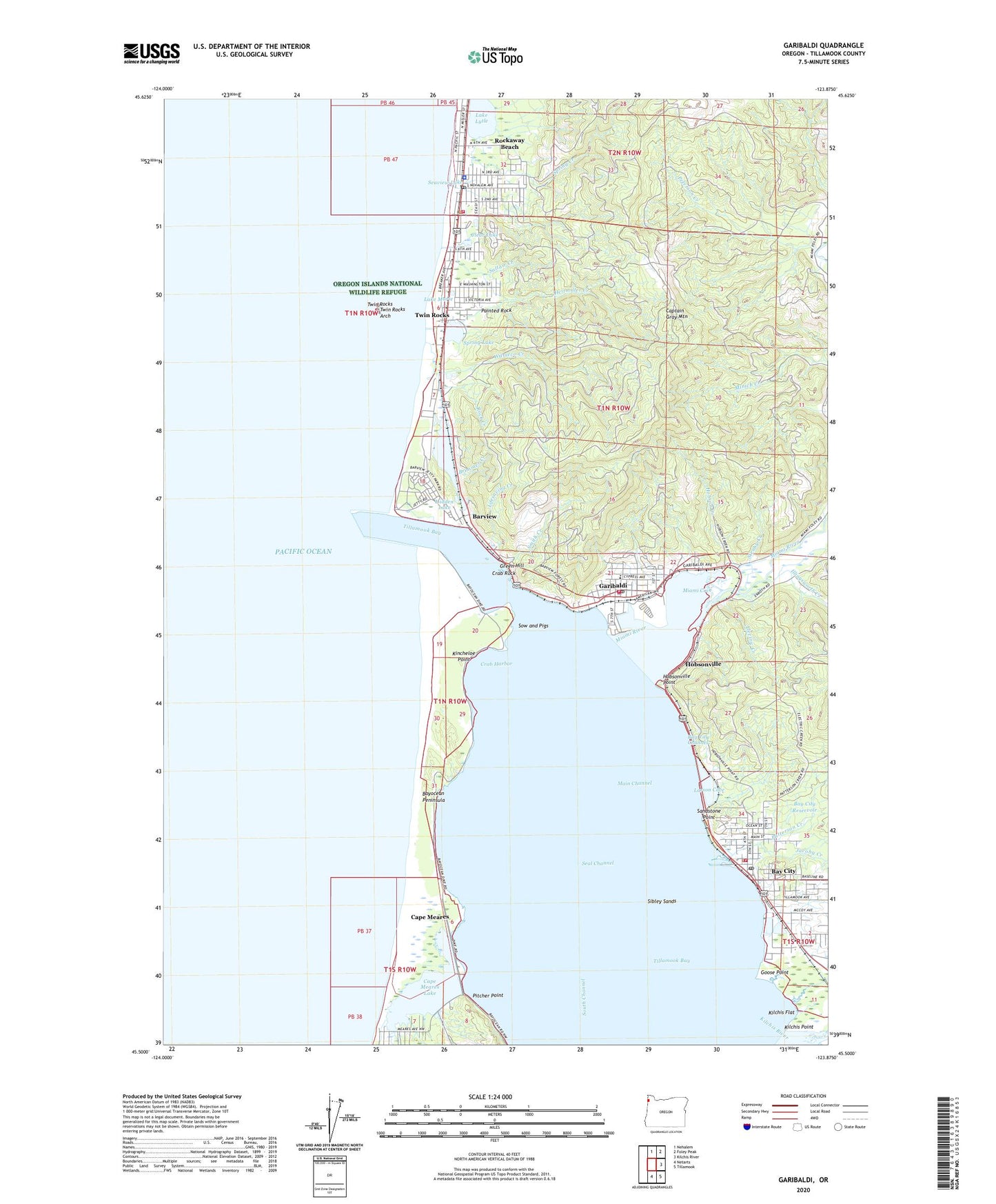
2020 topographic map quadrangle Garibaldi in the state of Oregon. Scale: 1:24000. Based on the newly updated USGS 7.5' US Topo map series, this map is in the following counties: Tillamook. The map contains contour data, water features, and other items you are used to seeing on USGS maps, but also has updated roads and other features. This is the next generation of topographic maps. Printed on high-quality waterproof paper with UV fade-resistant inks.
Quads adjacent to this one:
North: Nehalem
Northeast: Foley Peak
East: Kilchis River
Southeast: Tillamook
South: Netarts
Contains the following named places: Akron, Al Griffin Memorial Park, Bar View Post Office, Barnegat, Barnegat Post Office, Barview, Barview County Park, Baxter Creek, Bay City, Bay City Branch Marion Barr Library, Bay City Channel, Bay City Fire Department, Bay City Forest Park, Bay City Hall, Bay City Post Office, Bay City Public Works, Bay City Reservoir, Bay City Sewage Treatment Plant, Bayocean, Bayocean Dike, Bayocean Peninsula, Bayocean Peninsula County Park, Bayocean Post Office, Brimmer Creek, Camp Magruder, Cape Meares Census Designated Place, Cape Meares County Boat Launch, Cape Meares Lake, Captain Gray Mountain, Church of Jesus Christ of Latter Day Saints, City of Bay City, City of Garibaldi, City of Rockaway Beach, Clear Lake, Coleman Creek, Crab Harbor, Crab Rock, Doty Creek, Eck Creek, Electric Creek, Electric Creek Reservoir, Elmore Park, Garibaldi, Garibaldi Branch Library, Garibaldi City Hall, Garibaldi Dry Dock, Garibaldi Elementary School, Garibaldi Fire Department, Garibaldi Marina, Garibaldi Marina Boat Launch, Garibaldi Museum, Garibaldi Old Mill Marina Resort Boat Launch, Garibaldi Police Department, Garibaldi Post Office, Garibaldi Public Works, Garibaldi Sewage Treatment Plant, Goose Point, Green Hill, Heitmiller Creek, Hidden Lake, Hobson Creek, Hobsonville, Hobsonville Point, Hobsonville Post Office, Illingsworth Creek, Jacoby Creek, Joe Champion Creek, Kilchis Flat, Kilchis Point, Kilchis River Jetty, Kincheloe Point, Kincheloe Point Boat Access, Lake Lytle, Lake Lytle Post Office, Lake Marie, Larson Cove, Larson Creek, Lifesaving Creek, Main Channel, Miami, Miami Cove, Miami River, Middle Channel Dike, North Jetty, Ocean Lake Park, Oceanlake, Old Mill Marina Resort, Painted Rock, Paquet, Patterson Creek, Peterson Creek, Pitcher Point, Port of Bay City Boat Moorage, Port of Garibaldi, Rock Creek, Rockaway Beach, Rockaway Beach Branch Library, Rockaway Beach City Hall, Rockaway Beach City Park, Rockaway Beach Fire Department, Rockaway Beach Municipal Court, Rockaway Beach Police Department, Rockaway Beach Post Office, Rockaway Beach Public Works, Rockaway Beach State Park, Rockaway Beach Wastewater Treatment Plant, Saltair, Saltair Creek, Sandstone Point, Seal Channel, Seaview City Park, Seaview Lake, Sibley Sands, Smith Creek, Smith Lake, South Channel, South Jetty, Sow and Pigs, Spring Creek, Spring Lake, Stanger Memorial VFW Park, Steinhilber Creek, Struby Creek, Struby Creek Reservoir, Tillamook Bay, Tillamook County General Hospital Garibaldi Station, Twin Rocks, Twin Rocks Arch, Twin Rocks County Park, Twin Rocks Post Office, Twin Rocks Sanitary District, Twin Rocks State Park, United States Coast Guard Station Tillamook Bay, Watseco, Watseco Creek, ZIP Codes: 97107, 97118