MyTopo
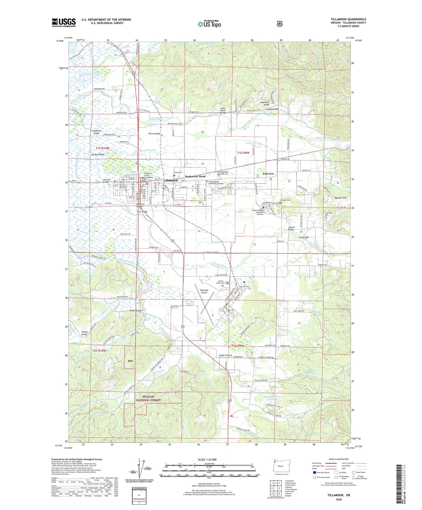
Tillamook Oregon US Topo Map
Couldn't load pickup availability
Also explore the Tillamook Forest Service Topo of this same quad for updated USFS data
2024 topographic map quadrangle Tillamook in the state of Oregon. Scale: 1:24000. Based on the newly updated USGS 7.5' US Topo map series, this map is in the following counties: Tillamook. The map contains contour data, water features, and other items you are used to seeing on USGS maps, but also has updated roads and other features. This is the next generation of topographic maps. Printed on high-quality waterproof paper with UV fade-resistant inks.
Quads adjacent to this one:
West: Netarts
Northwest: Garibaldi
North: Kilchis River
Northeast: Cedar Butte
East: The Peninsula
Southeast: Blaine
South: Beaver
Southwest: Sand Lake
This map covers the same area as the classic USGS quad with code o45123d7.
Contains the following named places: 9th Street Park, Airbase Reserve County Park, Anderson Creek, Balmer Hill, Bear Creek, Beaver Creek, Besters Ford, Bewley Creek, Blaser Bridge, Blaser Farms, Bureau of Land Management Tillamook Field Office, Burton Bridge County Boat Launch, Carnahan City Park Boat Ramp, Carnahan Park, Caufield Bar, Church of Jesus Christ of Latter Day Saints, City of Tillamook, Clarks Bar, Coal Creek Reservoir, Coastal View Dairy, Coastview Dairy, Department of Motor Vehicles Tillamook, Donaldson Creek, Dougherty Slough, East Elementary School, Fairview, Fairview Acres Dairy Farm, Fairview Census Designated Place, Fawcett Creek, Fawcett Creek Farm, First Baptist Church, Fred Meyer Park and Ride, Gienger Farms, Goodspeed Bridge, Goodspeed Park, Green Creek, Hall Slough, Hathaway Farms, Hathaway Mead, Hidden Acres Greenhouse, Hoquarten Slough, Hughey Creek, Jenck Dairy, Joe Creek, Johnson Bridge, Juno, Kelches River Ry Crossing, Kilchis Post Office, Kilchis River, Killam Creek, Killam Fawcett Reservoir, KTIL - AM, Latimer Quilt and Textile Center, Liberty Elementary School, Makinster Bridge, Marine Park, Marine Park Boat Ramp, Martin Dairy, Marys Creek, Matejeck Dairy, McKenzie Bridge, Mill Creek, Mountain Vista Dairy, Naval Air Station Post Office, Neilson Bridge, Neilson Slough, Nestocton, Nestocton Post Office, Nolan Slough, Oldenkamp Farms, Oregon State Police - Tillamook Station, Oregon Youth Authority - Camp Tillamook, Oregon Youth Authority - Tillamook Youth Correctional Facility, Orella Dairy, Ox Bow Bend, Pacific Christian School, Parks Landing County Boat Launch, Peace Park, Pleasant Valley Census Designated Place, Port of Tillamook Bay and Industrial Air Park Sewage Treatment Plant, Port of Tillamook Bay Biogas - Methane Digester Facility, Premium Farms, Prince Bridge, R and R Dairy, Sacred Heart Catholic Church, Sacred Heart Cemetery, Sanchez Dairy, Shady Oak Dairy, Silver Mist Farms, Simmons Creek, Slide Creek, Sollie Smith Bridge, Sollie Smith County Boat Launch, South Prairie, South Prairie Elementary School, Squeedunk Slough, Stasek Slough, Steiner County Boat Launch, Stillwell Bridge, Stillwell Ditch, Stillwell Park, Stillwell Slough, Sugarloaf Acres, Sunset Heights Memorial Gardens, Sutton Creek, The Barn Community Playhouse, Tilla Bay Farms, Tillamook, Tillamook Adventist School, Tillamook Air Museum, Tillamook Airport, Tillamook Bay Community College, Tillamook Christian Center, Tillamook City Hall, Tillamook County, Tillamook County Central Public Works, Tillamook County Fairgrounds Convention Center, Tillamook County Fairgrounds Outdoor Stage, Tillamook County Fairgrounds Racetrack, Tillamook County General Hospital, Tillamook County Pioneer Museum, Tillamook County Public Health Department, Tillamook County Rodeo and Fairgrounds, Tillamook County Sheriff's Office, Tillamook County TD Town Square Transit Center, Tillamook County Transportation District Park and Ride, Tillamook Fire District Station 71, Tillamook Fire District Station 72, Tillamook General Hospital Heliport, Tillamook High School, Tillamook IOOF Cemetery, Tillamook Junior High School, Tillamook Justice Courthouse, Tillamook Main Library, Tillamook Municipal Court, Tillamook Naval Air Station, Tillamook Police Department, Tillamook Post Office, Tillamook Public Works, Tillamook Reservoir, Tillamook River Safety Rest Area, Tillamook Sewage Treatment Plant, Tillamook Water Treatment Plant, Tone Bridge, Trask Fairview Pioneer Cemetery, Trask River High Schools - Camp Tillamook, Trask View Farm, Trout Cemetery, Valley Venture Farms, Victor Dairy, Whispering Pine Dairy, Wilson School, Wilsonview Dairy, Windy Haven Farm, Yankee Branch