MyTopo
Nehalem Oregon US Topo Map
Couldn't load pickup availability
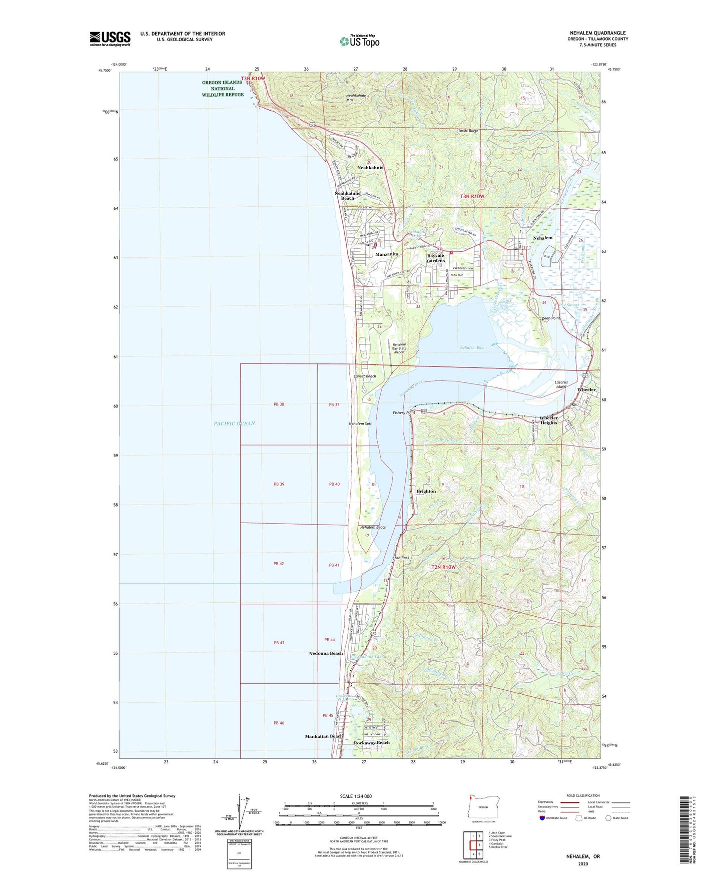
2024 topographic map quadrangle Nehalem in the state of Oregon. Scale: 1:24000. Based on the newly updated USGS 7.5' US Topo map series, this map is in the following counties: Tillamook. The map contains contour data, water features, and other items you are used to seeing on USGS maps, but also has updated roads and other features. This is the next generation of topographic maps. Printed on high-quality waterproof paper with UV fade-resistant inks.
Quads adjacent to this one:
North: Arch Cape
Northeast: Soapstone Lake
East: Foley Peak
Southeast: Kilchis River
South: Garibaldi
This map covers the same area as the classic USGS quad with code o45123f8.
Contains the following named places: Alder Creek, Bayside Gardens, Bayside Gardens Census Designated Place, Bobs Creek, Brighton, Brighton Marina, Brighton Post Office, Calvary Bible Church, Cheviot Creek, City of Manzanita, City of Nehalem, City of Wheeler, Classic Ridge, Clear Creek, Crab Rock, Crescent Creek, Crescent Lake, Dean Point, East Branch Gervais Creek, Fisher Creek, Fishers, Fishery Point, Gervais Creek, Haddon, Hall Street, Hoevet Post Office, Japanese Creek, Jetty, Jetty Creek, Jetty Fishery Marina, Jetty Fishery Marina Boat Launch, Lake Lyle County Boat Launch, Lazarus Island, Manhattan Beach, Manhattan Beach Post Office, Manhattan Beach State Park, Manzanita, Manzanita Branch Library, Manzanita City Hall, Manzanita City Park, Manzanita Department of Public Safety, Manzanita Fire Station Park and Ride, Manzanita Municipal Court, Manzanita Police Department, Manzanita Post Office, Manzanita Public Works, Manzanita Water Treatment Plant, McMillan Creek, Messhouse Creek, Moroney Canal, Neah - Kah - Nie Middle School, Neahkahnie, Neahkahnie Beach, Neahkahnie Census Designated Place, Neahkahnie Creek, Neahkahnie Lake, Neahkahnie Mountain, Neakahnie-Manzanita State Park, Nedonna Beach, Nedonna Creek, Nedonna Lake, Nehalem, Nehalem American Legion Cemetery, Nehalem Bay, Nehalem Bay County Boat Launch, Nehalem Bay Fire Department Station 13, Nehalem Bay State Airport, Nehalem Bay State Park, Nehalem Bay State Park Boat Ramp, Nehalem Bay Wastewater Agency, Nehalem Beach, Nehalem City Hall, Nehalem City Park, Nehalem Elementary School, Nehalem H Street Public Dock, Nehalem Junction, Nehalem Post Office, Nehalem Public Works, Nehalem Spit, Nehalem Tohls Street Public Dock, North Fork Nehalem River, North Jetty Nehalem Bay, Paradise Cove Resort and Marina, Paradise Cove Resort and Marina Boat Ramp, Pye Slough, River End Dairy, Seaview, South Jetty Nehalem Bay, Sunset Beach, Tillamook County General Hospital Manzanita Station, Tillamook County North District Public Works, Tubessing Creek, Vosburg Creek, Vosburg Post Office, Waterfront Park, Wheeler, Wheeler City Hall, Wheeler Heights, Wheeler Marina, Wheeler on the Bay Lodge and Marina, Wheeler Post Office, Wheeler Public Boat Ramp, Wheeler Public Works, Wheeler Siding, Wheeler Transient Tie Up, Wheeler Upper Park, Zimmerman Creek, ZIP Codes: 97130, 97136, 97147