MyTopo
Monmouth Oregon US Topo Map
Couldn't load pickup availability
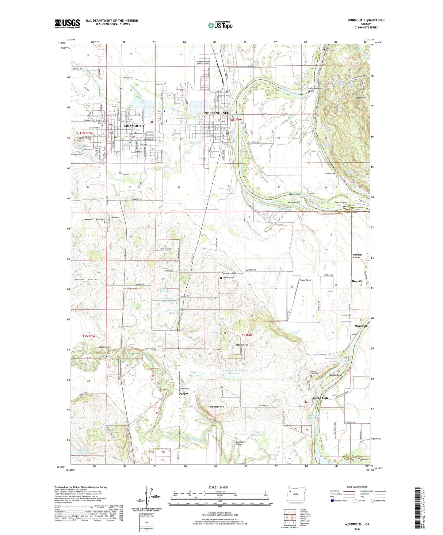
2020 topographic map quadrangle Monmouth in the state of Oregon. Scale: 1:24000. Based on the newly updated USGS 7.5' US Topo map series, this map is in the following counties: Polk, Marion, Linn. The map contains contour data, water features, and other items you are used to seeing on USGS maps, but also has updated roads and other features. This is the next generation of topographic maps. Printed on high-quality waterproof paper with UV fade-resistant inks.
Quads adjacent to this one:
West: Airlie North
Northwest: Dallas
North: Rickreall
Northeast: Salem West
East: Sidney
Southeast: Albany
South: Lewisburg
Southwest: Airlie South
Contains the following named places: Ash Creek, Ash Creek Intermediate School, Bloomington Post Office, Buena Vista, Buena Vista Cemetery, Buena Vista Community Church, Buena Vista County Park, Buena Vista Ferry Landing West, Buena Vista Post Office, Buena Vista Public Ferry Landing East, Campus Elementary School, Cauthorn, Cauthorn Spring, Cemetery Hill, Cemetery Hill Cemetery, Central High School, Cherry Lane Park, Christianson Reservoir, City of Independence, City of Monmouth, Clay Pit, Cupids Knoll, Davidson Bridge, Davidson Hill, Dicker Reservoir, Drazdoff Reservoir, Duck Slough, Earl Kennel Dam, Earl Kennel Reservoir, East Independence, Faust Field, Fircrest Cemetery, First Fruits Farm, Garrison Reservoir, Gentle Woods Park, Halls Ferry Cemetery, Hartman Slough, Helmick, Helmick Hill, Henry Hill Elementary School, Henry Hill Park, Heritage Museum, Hopville, Independence, Independence Bend, Independence City Hall, Independence Elementary School, Independence Municipal Courthouse, Independence Police Department, Independence Post Office, Independence Public Library, Independence Public Works, Independence Sewage Treatment Plant, Independence State Airport, Interstate Log Pond, Jensen Artic Museum, Johnson Hill, Le Mesa Park, Ledford, Little Santiam River, Living Word Faith Fellowship, Luckiamute River, Lundeen Reservoir, Madrona Park, Main Street Park, Marr Court Park, Mid Valley Christian Academy, Middle Fork Ash Creek, Modeville, Monmouth, Monmouth City Hall, Monmouth Elementary School, Monmouth Evangelical Church, Monmouth Municipal Courthouse, Monmouth Police Department, Monmouth Post Office, Monmouth Public Library, Monmouth Public Works, Monmouth Recreational Park, Monmouth Reservoir, Monmouth Sewage Treatment Plant, Monmouth-Independence Division, Mountain Fir Park, Murphy Bar, Neahr, Nisly Reservoir, North Fork Ash Creek, Olge Reservoir, Orville, Parker, Parker Post Office, Pfaff Park, Pioneer Park, Polk County Fire District 1 Station 40 Buena Vista, Polk County Fire District 1 Station 90, Polk County Park Public Boat Ramp, Riverview City Park, Riverview City Park Boat Ramp, Rose Lake, S and E Farms Independence Airstrip, Saint Patricks Church, Santiam River, Sarah Helmick State Park, Smith Cemetery, South Fork Ash Creek, Southgate Park, Stapleton, Talmadge Middle School, Tyson Island, V & S Junction, Vitae Springs, Wells Island, Wells Landing, Wendell Kreder Dam, Wendell Kreder Reservoir, Western Oregon University, Western Oregon University Baseball Stadium, Western Oregon University Leinwand Outdoor Stage, Western Oregon University McArthur Field Stadium, Western Oregon University New Physical Education Building, Western Oregon University Rice Auditorium, Whitesell Park, Wigrich, Wigrich Airfield, Wigrich Landing, Wigrich Spur, Winegar Park, WVRR Junction, ZIP Code: 97351