MyTopo
Chambersburg Pennsylvania US Topo Map
Couldn't load pickup availability
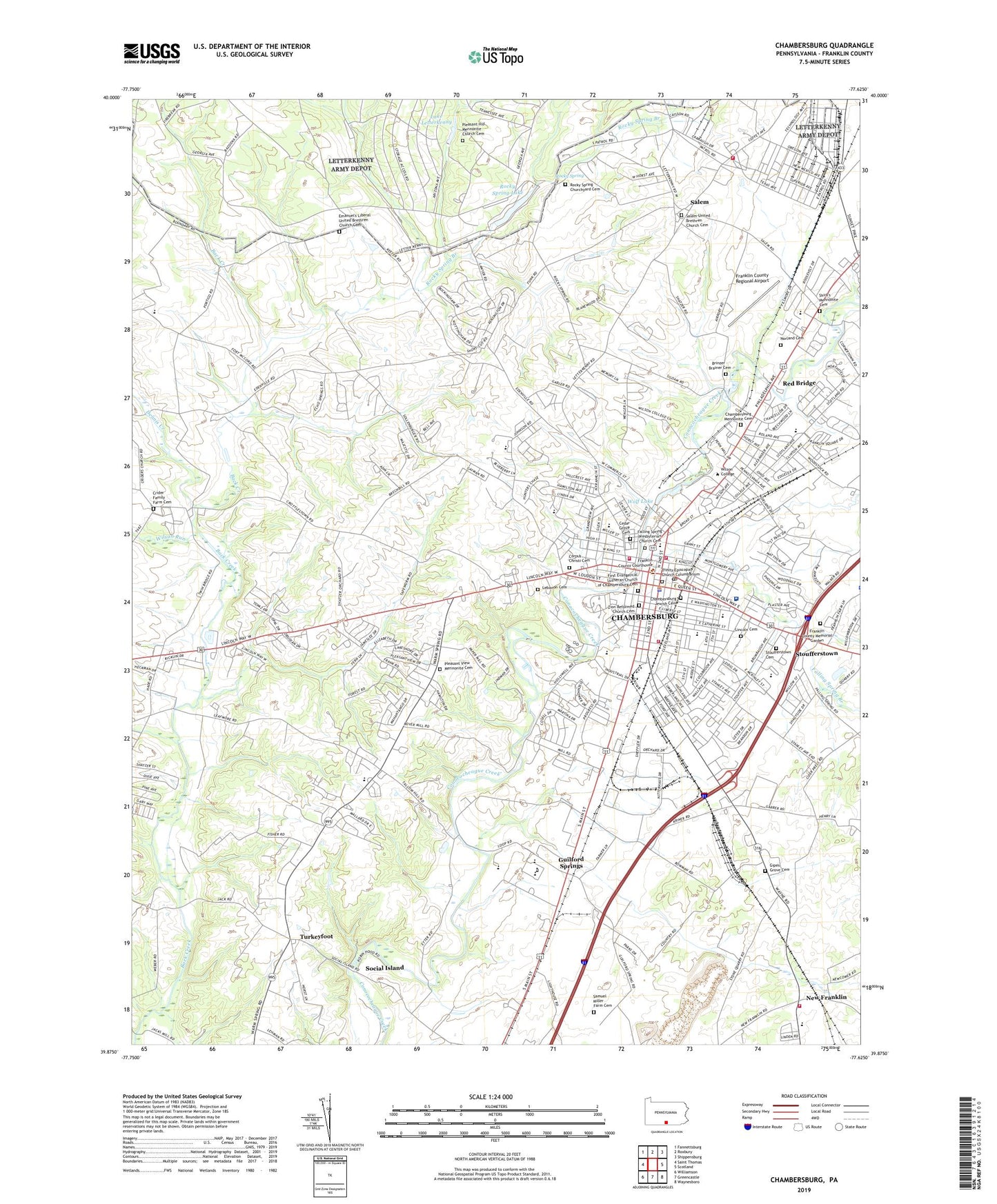
2023 topographic map quadrangle Chambersburg in the state of Pennsylvania. Scale: 1:24000. Based on the newly updated USGS 7.5' US Topo map series, this map is in the following counties: Franklin. The map contains contour data, water features, and other items you are used to seeing on USGS maps, but also has updated roads and other features. This is the next generation of topographic maps. Printed on high-quality waterproof paper with UV fade-resistant inks.
Quads adjacent to this one:
West: Saint Thomas
Northwest: Fannettsburg
North: Roxbury
Northeast: Shippensburg
East: Scotland
Southeast: Waynesboro
South: Greencastle
Southwest: Williamson
This map covers the same area as the classic USGS quad with code o39077h6.
Contains the following named places: Andrew Buchanan Elementary School, Art Studio, Borough of Chambersburg, Borough of Chambersburg Fire Department Good Will Steam Fire Engine and Hose Company 3, Borough of Chambersburg Fire Department Junior Volunteer Hose and Truck Company 2, Brinzer - Brainer Cemetery, Cedar Grove Cemetery, Chambersburg, Chambersburg Area Middle School, Chambersburg Area Senior High School, Chambersburg Fire Department Company 1 - Headquarters Station, Chambersburg Fire Department Company 1 - McKinley Street Station, Chambersburg Hospital Heliport, Chambersburg Jewish Cemetery, Chambersburg Mennonite Cemetery, Chambersburg Police Department, Chambersburgh Post Office, Charlotte I Davison Hall, Cheesetown, Coldbrook Elementary School, Corpus Christi Cemetery, Corpus Christi School, Crider Family Farm Cemetery, Culbertson Station, Dennis Creek, E F Goetz and Son Construction Corporation Heliport, Emanuel's Liberal United Brethren Church Cemetery, Falling Spring Branch, Falling Spring Presbyterian Church Cemetery, First Evangelical Lutheran Church of Chambersburg Cemetery, Frank E Gannett Memorial Field House, Franklin County, Franklin County Memorial Garden, Franklin County Regional Airport, Franklin County Sheriff's Office, Franklin County Special Education Center, Franklin County Vocational Technical School, Franklin Fire Company Station 4, Garfield School, Gipes Grove Cemetery, Guilford School, Guilford Springs, Hamilton Heights, Hamilton Heights Elementary School, Harmony Cottage, Harrison School, Hawthorne Indoor Arena, Helen M Beach 24 Veterinary Medical Center, Henry Riddle Hall, Holy Sprit Emergency Medical Services Chambersburg, Jensen Dining Hall, John Stewart Memorial Library, Kensington Heights, King Street Elementary School, Kitts Outdoor Arena, Lake Letterkenny, Lake Letterkenny Dam, Lebanon Cemetery, Lenfest Commons, Letterkenny Fire and Emergency Services, Lincoln Cemetery, Lortz Hall, Magil House, Margaret Criswell Disert Hall, Mary B Sharpe Elementary School, Mary Belle McElwain Hall, Mount Zion School, New Franklin, New Franklin Elementary School, New Franklin Volunteer Fire Department - Company 17, Norland Cemetery, Norland Hall, Norland Shopping Center, Olive Delp Overly Cook Indoor Arena, Paul Swain Havens Science Center, Pleasant Hill Mennonite Church Cemetery, Pleasant View, Pleasant View Mennonite Cemetery, Portico Elementary School, Portico School, Red Bridge, Rocky Spring, Rocky Spring Branch, Rocky Spring Churchyard Cemetery, Rocky Spring Dam, Rocky Spring Lake, Rosenkrans Hall, Salem, Salem United Brethren Church Cemetery, Samuel Miller Farm Cemetery, Shirk's Mennonite Cemetery, Social Island, South Gate Shopping Mall, South Hamilton School, Stoufferstown, Stoufferstown Cemetery, The Hankey Center, Tooke Farm House, Township of Hamilton, Trinity Episcopal Church Columbarium, Turkeyfoot, U L Gordy Elementary School, WCBG-AM (Chambersburg), WCHA-AM (Chambersburg), WellSpan Chambersburg Hospital, West Hamilton Heights, WIKZ-FM (Chambersburg), Wilson Run, Wolf Lake, Wolf Lake Dam, Zion Reformed Church Cemetery, ZIP Code: 17201