MyTopo
Collegeville Pennsylvania US Topo Map
Couldn't load pickup availability
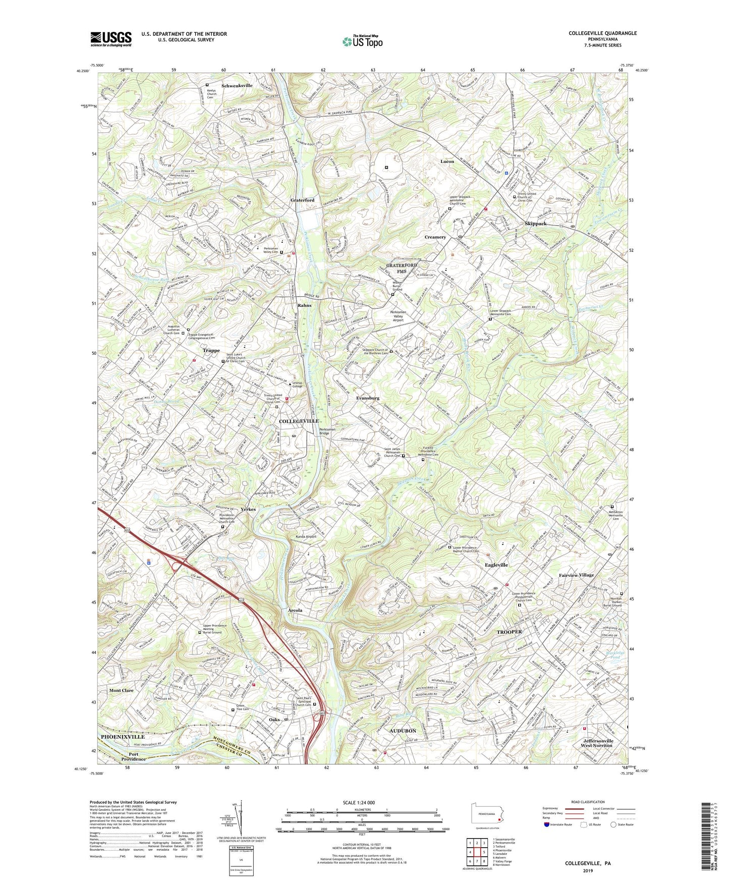
2019 topographic map quadrangle Collegeville in the state of Pennsylvania. Scale: 1:24000. Based on the newly updated USGS 7.5' US Topo map series, this map is in the following counties: Montgomery, Chester. The map contains contour data, water features, and other items you are used to seeing on USGS maps, but also has updated roads and other features. This is the next generation of topographic maps. Printed on high-quality waterproof paper with UV fade-resistant inks.
Quads adjacent to this one:
West: Phoenixville
Northwest: Sassamansville
North: Perkiomenville
Northeast: Telford
East: Lansdale
Southeast: Norristown
South: Valley Forge
Southwest: Malvern
Contains the following named places: Abruzzi Estates, Arbors at Providence, Arcola, Arcola Intermediate School, Arrowhead Elementary School, Arrowhead Knoll, Audobon Gardens, Audubon, Audubon Census Designated Place, Audubon Elementary School, Audubon Gardens, Audubon Post Office, Audubon Shrine, Audubon Village Shopping Center, Augustus Lutheran Church Cemetery, Berwick Place, Bomberger Memorial Hall, Borough of Collegeville, Borough of Trappe, Boyer School, Burnridge Center Shopping Center, Burnside Elementary School, Camp Rainbow, Camp Sholom, Cassel Mill Farms, Central Perkiomen Park, Central Perkiomen Valley Park, Chadwick Place, Chesterbrook Academy, Coldspring Crossing, Collegeville, Collegeville Arms, Collegeville Borough Park, Collegeville Crossing, Collegeville Dam, Collegeville Glen, Collegeville Greene, Collegeville Post Office, Collegeville Shopping Center, Collegeville-Trappe High School, Collegeville-Trappe School, Colony Arms, Corson Hall, Country Club Dam, Creamery, Creamery Dam, Creamery Post Office, Creekwood Village, Crestview at Skippack, Crossmans Run, D L Helfferich Hall of Health and Physical Education, Doctor John Price Field, Doe Run, Donny Brook, Donny Brook Estates, Eagel Stream, Eagleville, Eagleville Census Designated Place, Eagleville Elementary School, Eagleville Hospital, Eagleville Hospital Rehabilitation Center, Eagleville Post Office, East Branch Perkiomen Creek, Effie Brant Evans Hockey Field, Eleanor Frost Snell Softball Field, Estates at Collegeville, Estates at Faraway Farm, Evansburg, Evansburg Census Designated Place, Evansburg Crossing, Evansburg State Park, Evansburg State Park Nature Center, Everett "Ace" Bailey Tennis Courts, Fair Hills, Fairview Christian Academy, Fairview Village, Fairview Village Post Office, Fox Heath, Freeman Camp, Frog Hollow Estates, Funkite Providence Mennonite Cemetery, Graterford, Green Tree, Green Tree Cemetery, Greenshire Estates, Greenview Estates, Gypsy Rose Estates, Harmony Towne, Heather View, Indian Head Park Dam, Iron Bridge Estates, Ironbridge Estates, Jacob Reiff Park, Jeanne Rosset French Memorial Park, Jeffersonville Golf Club, Keelys Church Cemetery, Ken Crest Center, Kunda Airport, Landis Creek, Lochwood Estates, Lodal Creek, Lower Perkiomen Valley County Park, Lower Providence Baptist Church Cemetery, Lower Providence Post Office, Lower Providence Presbyterian Church Cemetery, Lower Skippack Mennonite Cemetery, Lucon, Marklelys Pond, Methacton High School, Methacton Mennonite Cemetery, Mews at Valley Forge, Mill Grove, Moister Tract, Mont Clare Census Designated Place, Montgomery County Boys Club, Montgomery County Prison Farm, Montgomery Hill Detention Home, Norrington Knoll, Norriton Dunker Burial Ground, Oaks, Oaks Corporate Center, Oaks Elementary School, Oaks Post Office, Olde Village, Palm Beach Farm, Pathway School, Pennington Reserve at Upper Providence, Pennypacker Road, Perkiomen, Perkiomen Bridge, Perkiomen Greene, Perkiomen Park, Perkiomen Valley Airport, Perkiomen Valley Cemetery, Perkiomen Valley Convalescent Home, Perkiomen Valley Elementary School, Perkiomen Valley High School, Perkiomen Valley New Beginning School, Perkiomen Woods, Pickering Creek, Pin Oak Estates, Pineview Estates, Port Providence, Providence Business Center at Oaks, Providence Corporate Center, Providence Crossing, Providence Green, Providence Knoll, Providence Meadows, Providence Mennonite Church Cemetery, Providence Oaks, Providence Ridge, Providence Square, Providence View, Rahns, Regency Knoll, Ridge Pike Plaza, Ridge Pike Plaza Shopping Center, River Crest Preventorium, River Crest School, Robert Patterson Field, Rolling Turf Golf Club, Saint Eleanor School, Saint Elinors School, Saint James Perkiomen Church Cemetery, Saint Luke's United Church of Christ Cemetery, Saint Paul's Episcopal Church Cemetery, Schoolhouse Run, Shady Brook Run, Skippack, Skippack Census Designated Place, Skippack Church of the Brethren Cemetery, Skippack Creek, Skippack Golf Course, Skippack Post Office, Skippack Ridge, Skippack School, Squirrel Hill Heliport, State Correctional Institution Graterford, Sugar Hill Farms, Sunnyside Farms, The Colony at Valley Forge, The Estates at Fawn Ridge, The Estates of Audubon North, The Estates of Audubon South, The Marketplace at Collegeville Shopping Center, The Meadows at Providence Reserve, The Pines, The Reserve, The Woods at Providence Reserve, Towamencin Creek, Township of Lower Providence, Township of Perkiomen, Township of Skippack, Township of Upper Providence, Township of West Norriton, Trappe, Trappe Center Shopping Center, Trappe Evangelical Congregational Cemetery, Trappe Meadows, Trinity United Church of Christ Cemetery, Trooper, Trooper Census Designated Place, Trooper Mobile Home Park, Upper Fairview, Upper Providence Industrial Park, Upper Providence Meeting Burial Ground, Upper Providence School, Upper Providence Township Park, Upper Skippack Mennonite Church Cemetery, Ursinus College, Valley Forge Baptist Temple Academy, Valley Forge Business Center, Valley Hi East, Villa of Flair Skippack Village, Visitation School, Warlgya Tract, Washington Country Club, Weatherlea, West Branch Skippack Creek, West Norriton, West Norriton Census Designated Place, Westover Golf Course, Wismer Burial Ground, Wooded Glen, Woodland Elementary School, Worcester Heliport, Yerkes, Yerkes Station, Zacharias Creek, ZIP Codes: 19403, 19426, 19453, 19456, 19474