MyTopo
Sassamansville Pennsylvania US Topo Map
Couldn't load pickup availability
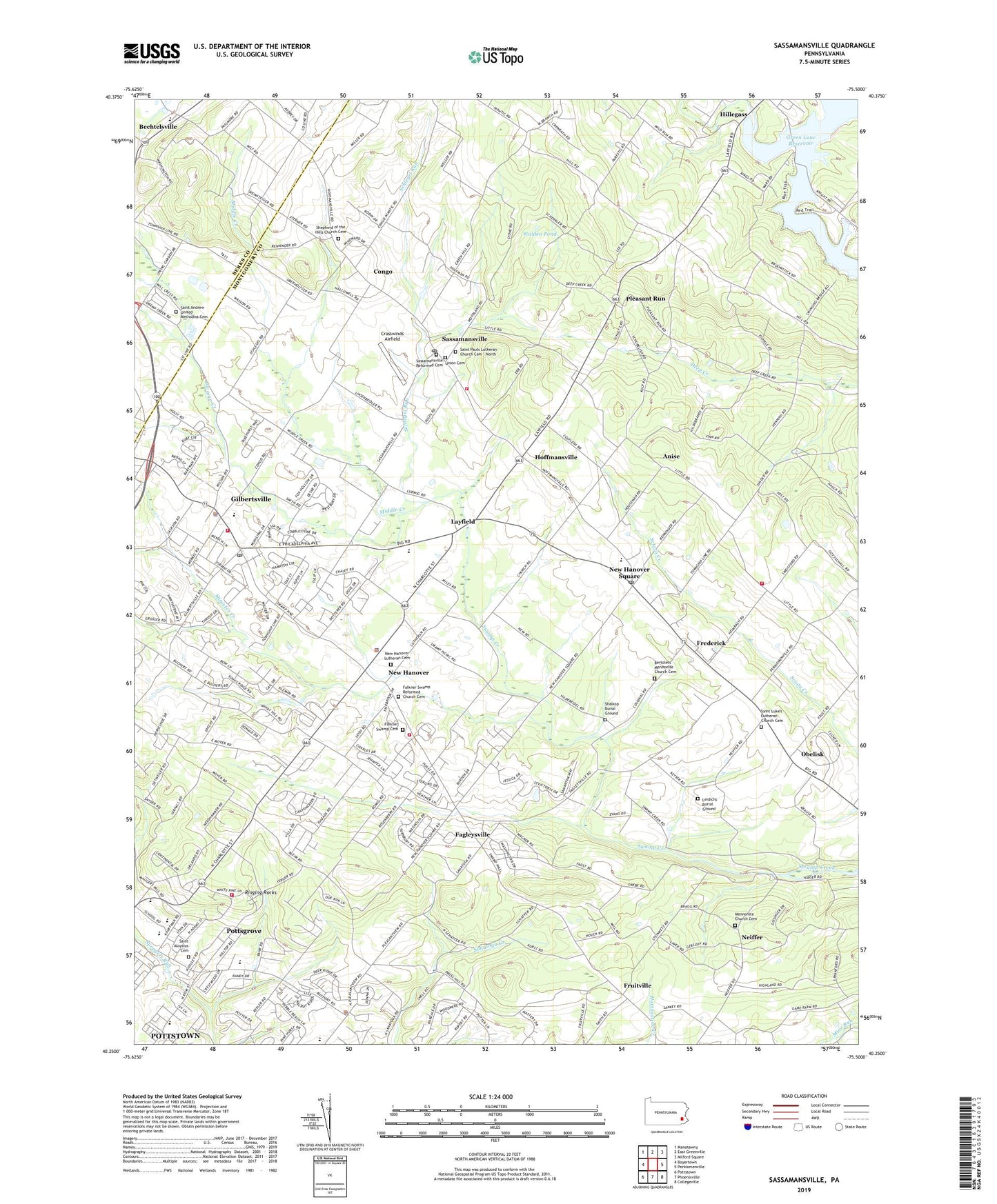
2023 topographic map quadrangle Sassamansville in the state of Pennsylvania. Scale: 1:24000. Based on the newly updated USGS 7.5' US Topo map series, this map is in the following counties: Montgomery, Berks. The map contains contour data, water features, and other items you are used to seeing on USGS maps, but also has updated roads and other features. This is the next generation of topographic maps. Printed on high-quality waterproof paper with UV fade-resistant inks.
Quads adjacent to this one:
West: Boyertown
Northwest: Manatawny
North: East Greenville
Northeast: Milford Square
East: Perkiomenville
Southeast: Collegeville
South: Phoenixville
Southwest: Pottstown
This map covers the same area as the classic USGS quad with code o40075c5.
Contains the following named places: Alto Grandview Acres, Anise, Bertolets Church, Bertolets Mennonite Church Cemetery, Birchwood Terrace, Boyertown East Junior High School, Brookeside Montessori School, Cedar Grove, Cedarville, Congo, Crosswinds Airfield, Doctor Jackson Dam, Douglass Township Police Department, Drewniany-Springmeadow Airport, Eastern State Game Farm, Fadler Airport, Fagleysville, Falkner Swamp Cemetery, Falkner Swamp Reformed Church Cemetery, Frederick, Fredrick Post Office, Fruitville, Gilbertsville, Gilbertsville Area Community Ambulance Services Medic 332, Gilbertsville Census Designated Place, Gilbertsville Fire and Rescue Company - Station 67, Gilbertsville Golf Course, Gilbertsville Post Office, Grandview Speedway, Green Lane Reservoir, Hansen Airport, Herstien Chapel, Hickory Park Dam, Hickory Valley Golf Course, Hillegass, Hoffmansville, Keelors Union Church, Kingdom Hall Church, Kurtz Airport, Layfield, Leidichs Burial Ground, Lower Pottsgrove Elementary School, Lower Pottsgrove Township Police Department, Mennonite Church Cemetery, Middle Creek, Minister Creek, Neiffer, New Hanover, New Hanover Airport, New Hanover Fire Company 1 Station 37, New Hanover Lutheran Cemetery, New Hanover Square, New Hanover Township Police Department, New Hanover-Upper Frederick Elementary School, Obelisk, Pleasant Run, Pleasant View Acres, Pottsgrove, Pottsgrove Census Designated Place, Pottsgrove High School, Pruss Hill Dam, Randy Run, Ridge Estates, Ringing Hill Fire Company - Station 59, Ringing Hills, Ringing Rock Dam, Ringing Rock Gardens, Ringing Rock Park, Ringing Rocks, Ringing Rocks Elementary School, Saint Aloysius Cemetery, Saint Andrew United Methodist Cemetery, Saint Andrews United Methodist Church, Saint Luke's Lutheran Church Cemetery, Saint Pauls Lutheran Church Cemetery - North, Saint Pius X High School, Sassamansville, Sassamansville Fire Company - Station 68, Sassamansville Post Office, Sassamansville Reformed Cemetery, Schlegel Run, Shalkop Burial Ground, Shepherd of the Hills Church Cemetery, Township of Douglass, Township of Lower Pottsgrove, Township of New Hanover, Township of Upper Frederick, Trinity Evangelical Christian Church, Twin Ponds Golf Course, Union Cemetery, Upper Frederick Fire Company - Station 87, Walden Pond, West Branch Perkiomen Creek, Woodgate, ZIP Codes: 18074, 19435, 19464, 19472, 19525, 19545