MyTopo
Columbia East Pennsylvania US Topo Map
Couldn't load pickup availability
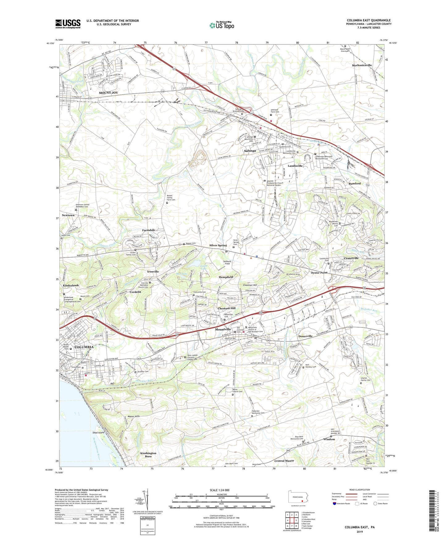
2023 topographic map quadrangle Columbia East in the state of Pennsylvania. Scale: 1:24000. Based on the newly updated USGS 7.5' US Topo map series, this map is in the following counties: Lancaster. The map contains contour data, water features, and other items you are used to seeing on USGS maps, but also has updated roads and other features. This is the next generation of topographic maps. Printed on high-quality waterproof paper with UV fade-resistant inks.
Quads adjacent to this one:
West: Columbia West
Northwest: Elizabethtown
North: Manheim
Northeast: Lititz
East: Lancaster
Southeast: Conestoga
South: Safe Harbor
Southwest: Red Lion
This map covers the same area as the classic USGS quad with code o40076a4.
Contains the following named places: Amos Herr Park, Bamford, Blue Rock Mennonite Cemetery, Borough of Columbia, Borough of Mountville, Bruckarts Station, Centerville, Centerville Cemetery, Centerville Elementary School, Centerville Junior High School, Central Manor Airport, Charles Family Cemetery, Charnelle Farm, Chestnut Hill, Chestnut Hill Church, Columbia Borough Fire Department Station 80, Columbia Consolidated Fire Department Station 807, Columbia Junior Senior High School, Concordia Cemetery, Concordia Church, Cookman Church, Cordelia, Cordelia Station, Dellinger Run, Donerville, East Hempfield Township Police Department, Elm Tree School, Farmdale, Garden Spot Air Park, Glatfelter Memorial Field, Grabb Lake, Green Acres Farm, Grider Family Cemetery, Habecker Church, Habecker Mennonite Cemetery, Hazardous Materials Environmental Fire Rescue Team Station 2, Hempfield, Hempfield Fire Department Station 69, Hempfield High School, Hempfield Shopping Center, Herr Cemetery Number 51, Herr Graveyard Number 90, Hidden Acres Farm, Hiestand Farm Cemetery, Hillside Farm, Hodecker Celery Farm, Indian Springs Golf Course, Ironville, Ironville Methodist Church Cemetery, John Mann Cemetery, Kinderhook, Kinderhook Evangelical Congregational Cemetery, Lackard Park, Lancaster Junction Farm, Landis Farm, Landisville, Landisville Census Designated Place, Landisville Mennonite Cemetery, Landisville Post Office, Landisville Quarry, Landisville Reformed Mennonite Cemetery, Landville Elementary School, Manor Church, Manor Church Cemetery, Manor Hills, Manor Knoll Personal Use Airport, Martin's Hatchery Poultry Farm, Mc Ginness Airport, Meadow Lane Dairy, Mechanicsville, Moore Cemetery, Moore Miller Graveyard, Mount Bethel Cemetery, Mountville, Mountville Cemetery, Mountville Church of the Brethern Cemetery, Mountville Elementary School, Mountville Fire Company 1 Station 7, Mountville Post Office, Mud Lake, Musselman Minich Cemetery, Musser Cemetery, Musser Family Farm Cemetery, Neff - Hershey Cemetery, Newtown, Newtown Post Office, Newtown United Methodist Cemetery, Novak Greenhouse, Old Colonial Cemetery, Oyster Point, Park Elementary School, Rohrer Dairy Farm, Saint Anne Home, Saint Joseph Convent Chapel Cemetery, Saint Josephs Academy, Salunga, Salunga Brethren Cemetery, Salunga Census Designated Place, Salunga Mennonite Cemetery, Salunga Park, Salunga Post Office, Salunga-Landisville Census Designated Place, Sauder Farm, Shad Island, Sherk Cemetery, Silver Spring, Silver Spring Cemetery, Silver Spring Post Office, Sporting Valley Turf Farms, Spring Valley Dairy, Stauffer Farms, Strickler Cemetery, Strickler Run, Sunburst Field, Taylor School, Township of East Hempfield, Township of West Hempfield, Trinity Cemetery, Walnut Grove Airport, Washington Boro Census Designated Place, Wayside Presbyterian Church Memorial Garden, WCLY-AM (Columbia), West Hempfield Fire and Rescue Company Station 76, West Hempfield Township Park, West Hempfield Township Police Department, WHEX-AM (Columbia), Wilton Airport, Windom, WLAN-FM (Lancaster), ZIP Codes: 17512, 17538, 17554