
MyTopo
Conyngham Pennsylvania US Topo Map
Couldn't load pickup availability
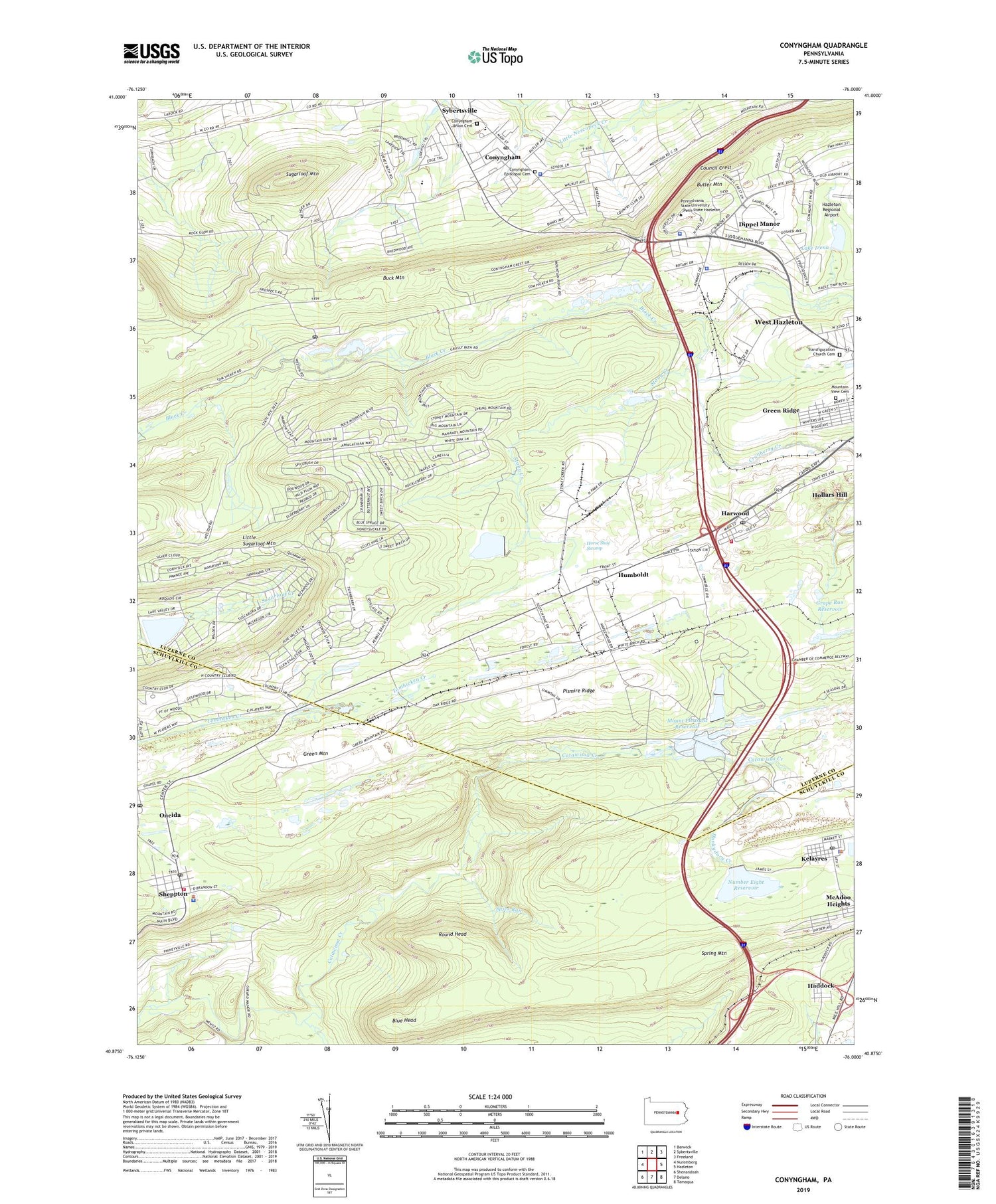
2023 topographic map quadrangle Conyngham in the state of Pennsylvania. Scale: 1:24000. Based on the newly updated USGS 7.5' US Topo map series, this map is in the following counties: Luzerne, Schuylkill. The map contains contour data, water features, and other items you are used to seeing on USGS maps, but also has updated roads and other features. This is the next generation of topographic maps. Printed on high-quality waterproof paper with UV fade-resistant inks.
Quads adjacent to this one:
West: Nuremberg
Northwest: Berwick
North: Sybertsville
Northeast: Freeland
East: Hazleton
Southeast: Tamaqua
South: Delano
Southwest: Shenandoah
This map covers the same area as the classic USGS quad with code o40076h1.
Contains the following named places: Audenried Colliery, Black Ridge Colliery, Blue Head, Borough of Conyngham, Borough of West Hazleton, Butler Mountain, Conyngham, Conyngham Episcopal Cemetery, Conyngham Post Office, Conyngham Station, Conyngham Union Cemetery, Council Crest, Cranberry Creek, Cross Run, Dippel Manor, East Union Township Police Department, Grape Run Dam, Grape Run Reservoir, Green Ridge, Green View, Haddock, Harleigh Junction, Harwood, Harwood Fire Company Station 241, Harwood Junction Station, Harwood Mines Post Office, Hazleton Water Works, Hollars Hill, Honey Brook Colliery, Horse Shoe Swamp, Humboldt, Humboldt Colliery, Humboldt Dam, Humboldt Fire Tower, Humboldt Reservoir, Hunkydory Creek, Kelayres, Kelayres Census Designated Place, Kelayres Post Office, Kline Township Police Department, Lake Choctaw Dam, Lake Irena, Lake Irena Dam, Lake Susquehanna, Lake Susquehanna Dam, Little Sugarloaf Mountain, Long Run, Lower Mount Pleasant Dam, Messers Run, Mount Pleasant Reservoir, Mountain View Cemetery, Number Eight Reservoir, Oakbur Junction, Oneida Census Designated Place, Oneida Post Office, Pennsylvania State Police Troop N Headquarters and Hazleton Station, Pennsylvania State University - Hazleton Campus, Pismire Ridge, Round Head, Sheppton, Sheppton - Oneida Volunteer Fire Company District 9 Station 2, Sheppton Census Designated Place, Sheppton Post Office, Silver Brook Junction, Spies Run, Stony Creek, Sugarloaf Mountain, Sugarloaf Post Office, Sugarloaf School, Tomhicken, Tomhicken Shaft Number Four, Tomhickon Colliery, Township of East Union, Township of Kline, Township of Sugarloaf, Transfiguration Church Cemetery, Upper Mount Pleasant Dam, Wolffs Run, WWKC-AM (West Hazelton), ZIP Codes: 18202, 18219, 18231, 18242, 18248, 18249


