MyTopo
Delano Pennsylvania US Topo Map
Couldn't load pickup availability
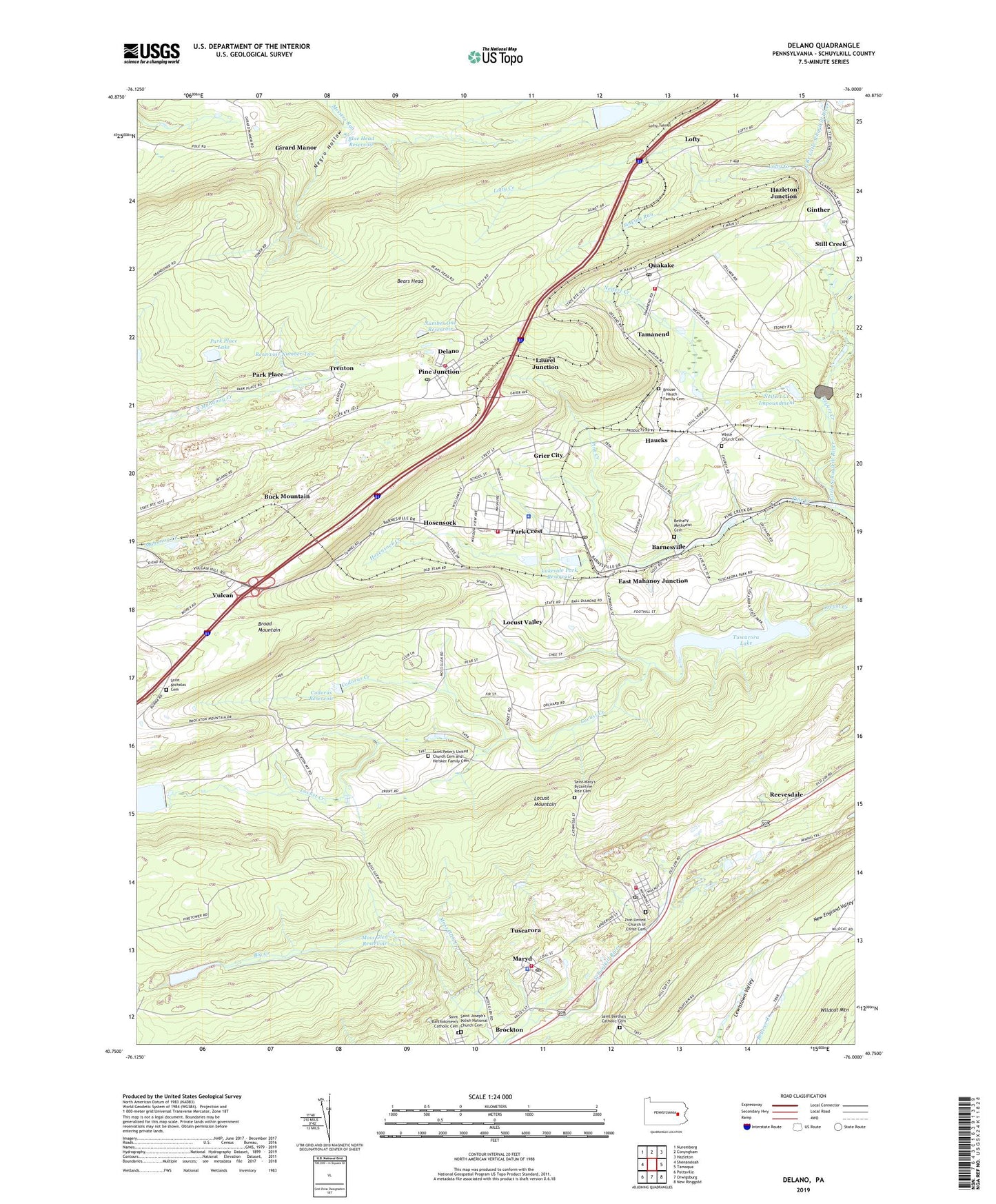
2023 topographic map quadrangle Delano in the state of Pennsylvania. Scale: 1:24000. Based on the newly updated USGS 7.5' US Topo map series, this map is in the following counties: Schuylkill. The map contains contour data, water features, and other items you are used to seeing on USGS maps, but also has updated roads and other features. This is the next generation of topographic maps. Printed on high-quality waterproof paper with UV fade-resistant inks.
Quads adjacent to this one:
West: Shenandoah
Northwest: Nuremberg
North: Conyngham
Northeast: Hazleton
East: Tamaqua
Southeast: New Ringgold
South: Orwigsburg
Southwest: Pottsville
This map covers the same area as the classic USGS quad with code o40076g1.
Contains the following named places: Barnesville, Barnesville Post Office, Bears Head, Bendinsky Airport, Bethany Methodist Cemetery, Blue Head Dam, Blue Head Reservoir, Broad Mountain Dam, Broad Mountain Reservoir, Brouse - Hauch Family Cemetery, Buck Mountain, Codorus Creek, Codorus Dam, Codorus Reservoir, Delano, Delano Census Designated Place, Delano Fire Company District 6 Station 1, Delano Post Office, East Branch Little Schuylkill River, East Mahanoy Junction, Ginther, Girard Manor, Grier City, Grier City Census Designated Place, Grier City-Park Crest Census Designated Place, Haucks, Hazleton Junction, Hersker Family Cemetery, Hosensock, Hosensock Creek, Hosensock Dam, Lakeside Dam, Lakeside Park Reservoir, Lakeside School, Lakewood Dam, Laurel Junction, Little Schuylkill Dam, Locust Creek Dam, Locust Lake, Locust Lake Dam, Locust Valley, Lofty, Lofty Creek, Lofty Reservoir, Lofty Reservoir Dam, Lofty Tunnel, Mahanoy Dam Number Two, Mahanoy Tunnel Station, Mary D Fire Company District 27 Station 2, Mary D Post Office, Maryd, Messerschmidt School, Mintzers Siding, Moss Glen Creek, Moss Glen Reservoir, Negro Hollow, Neifert Creek, Neifert Creek Dam, Neifert Creek Impoundment, Number One Dam, Number One Reservoir, Old Silver Brook, Park Crest, Park Crest Census Designated Place, Park Place, Park Place Dam Number Three, Park Place Lake, Pine Creek, Pine Junction, Quakake, Quakake Junction, Quakake Post Office, Quakake Volunteer Fire Company District 25 Station 2, Reevesdale, Reservoir Number Two, Ryan Township Fire and Rescue District 26 Station 1, Ryan Township Police Department, Saint Bartholomew's Catholic Cemetery, Saint Bertha's Catholic Cemetery, Saint Joseph's Polish National Church Cemetery, Saint Mary's Byzantine Rite Cemetery, Saint Nicholas Cemetery, Saint Peters Church, Schuylkill Township Police Department, Silver Fire Tower, Sinking Run, Still Creek, Swift Creek Dam, Tamanend, Township of Delano, Township of Ryan, Township of Schuylkill, Trenton, Tuscarora, Tuscarora Census Designated Place, Tuscarora Fire Company District 27 Station 3, Tuscarora Lake, Tuscarora Post Office, Tuscarora State Park, Vulcan, Walborn School, White Church Cemetery, Wildcat Airport, WZTA-FM (Tamaqua), Zion United Church of Christ Cemetery, ZIP Codes: 17925, 17948, 17952, 17953, 17982, 18214, 18220, 18245