MyTopo
Dalton Pennsylvania US Topo Map
Couldn't load pickup availability
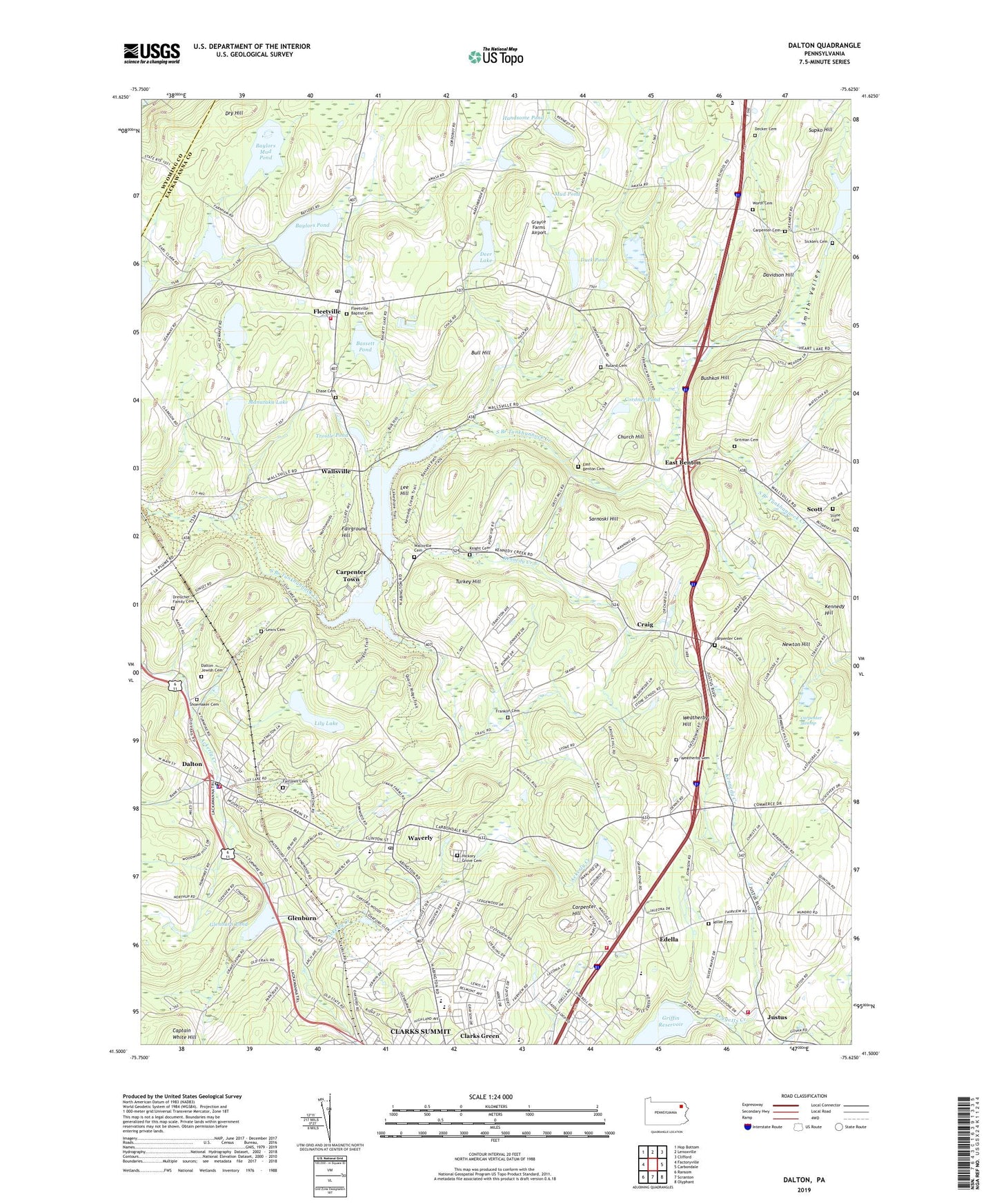
2019 topographic map quadrangle Dalton in the state of Pennsylvania. Scale: 1:24000. Based on the newly updated USGS 7.5' US Topo map series, this map is in the following counties: Lackawanna, Wyoming. The map contains contour data, water features, and other items you are used to seeing on USGS maps, but also has updated roads and other features. This is the next generation of topographic maps. Printed on high-quality waterproof paper with UV fade-resistant inks.
Quads adjacent to this one:
West: Factoryville
Northwest: Hop Bottom
North: Lenoxville
Northeast: Clifford
East: Carbondale
Southeast: Olyphant
South: Scranton
Southwest: Ransom
Contains the following named places: Abington Hills Horse Farm, Ackerly Creek, Ackerly Fairgrounds, Amasa, Basset Dam, Bassett Pond, Baylors Corners, Baylors Lake Dam, Baylors Mud Pond, Baylors Pond, Benton Industrial Park, Blakely Home, Borough of Clarks Green, Borough of Dalton, Bull Hill, Bushkos Hill, Captain White Hill, Carpenter Cemetery, Carpenter Hill, Carpenter Swamp, Carpenter Town, Chase Cemetery, Chinchilla Hose Company Station 2 - A, Church Hill, Cordner Pond, Craig, Dalton, Dalton Borough Police Department, Dalton Jewish Cemetery, Dalton Post Office, Dalton Volunteer Fire Company Station 5, Davidson Corners, Davidson Hill, Decker Cemetery, Deer Lake, Dreischer Family Cemetery, Dry Hill, Duck Pond, East Benton, East Benton Cemetery, Edella, Endless Mountains Airport, Fairground Hill, Fairlawn Cemetery, Fleetville, Fleetville Baptist Cemetery, Fleetville Post Office, Fleetville Volunteer Fire Company Station 63, Franklin Cemetery, Glen Oak Country Club, Glenburn, Glenburn Census Designated Place, Glenburn Dam, Glenburn Pond, Grayce Farms Airport, Griffin Reservoir, Gritman Cemetery, Handsome Pond, Hickory Grove Cemetery, House of the Good Shepherd, Humphreysville, Ivy Industrial Park, Justus, Justus Volunteer Fire Company Station 28, Kamp Kewanee, Kennedy Creek, Kennedy Hill, Knight Cemetery, Kochners Corners, La Plume Station, Lackawanna Dam, Lackawanna Lake, Lackawanna State Park, Lake Kewanee, Lakeland Golf Course, Lee Hill, Lewis Cemetery, Lily Lake, Manataka Lake, Millars School, Miller Cemetery, Mud Pond, Newton Hill, Ruland Cemetery, Sarnoski Hill, Scott, Shoemaker Cemetery, Sickler Dam, Sicklers Cemetery, Smith Corners, Smith Valley, Stevenson Pond, Stone Cemetery, Supko Hill, Township of Abington, Township of Benton, Township of Glenburn, Township of North Abington, Trostle Pond, Turkey Hill, Wallsville, Wallsville Cemetery, Waverly, Waverly Census Designated Place, Waverly Elementary School, Waverly Post Office, Weatherby Cemetery, Weatherby Hill, Worth Cemetery, Worth Church, ZIP Codes: 18414, 18420, 18471