MyTopo
Dawson Pennsylvania US Topo Map
Couldn't load pickup availability
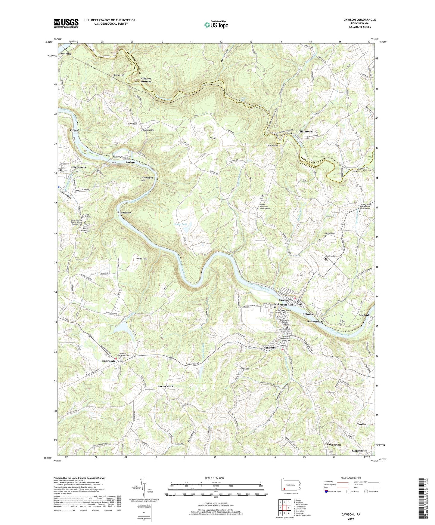
2023 topographic map quadrangle Dawson in the state of Pennsylvania. Scale: 1:24000. Based on the newly updated USGS 7.5' US Topo map series, this map is in the following counties: Fayette, Westmoreland. The map contains contour data, water features, and other items you are used to seeing on USGS maps, but also has updated roads and other features. This is the next generation of topographic maps. Printed on high-quality waterproof paper with UV fade-resistant inks.
Quads adjacent to this one:
West: Fayette City
Northwest: Donora
North: Smithton
Northeast: Mount Pleasant
East: Connellsville
Southeast: South Connellsville
South: Uniontown
Southwest: New Salem
This map covers the same area as the classic USGS quad with code o40079a6.
Contains the following named places: Alliance Furnace, Arnold Farm Dam, Barren Run, Bethel Cemetery, Borough of Dawson, Borough of Vanderbilt, Bowman - Flatwoods Cemetery, Brownfield Elementary School, Bryan Church, Bryan Methodist Church Cemetery, Buena Vista, Chaintown, Cochran Cemetery, Creek Falls, Cunningham School, Dawson, Dawson Post Office, Dawson Volunteer Fire Company Station 11, Dawson-Vanderbilt School, Dickerson Family Cemetery, Dickerson Run, Dickerson Run - Union Cemetery, Dickerson Run Liberty and Vanderbilt Volunteer Fire Department Station 10, Dickerson Run Post Office, East Liberty Presbyterian Church Cemetery, Emergency Medical Services Southwest Perryopolis, Fayette Emergency Medical Services Tri - Town Station, Flatwoods, Flatwoods Volunteer Fire Department Station 48, Fort Hill, Franklin Elementary School, Fuller, Furnace Run, Gault School, Hickman Run, Hulltown, Jackson School, Jefferson School, Kier, Kilndigging Hill, Laurel Run, Layton, Layton Hill, Liberty, Linden Hall Country Club, Linden Lake, Meadow Run, Morrow Hollow, Mount Washington Cemetery, Nellie, Perryopolis Post Office, Pleasant Grove School, Quay School, Raineytown, River Hills, Rogerstown, Roundbottom, Roundtop, Sacred Heart Roman Catholic Cemetery, Saint John the Baptist Roman Catholic Cemetery, Saint Nicholas Cemetery, Sandy Hollow, Smiley Run, Spring Grove Chapel, State Game Lands Number 296, Stickel Hollow, Township of Franklin, Township of Lower Tyrone, Township of Perry, Tunnel Hill, Tyrone Church, Tyrone School, Tyrone United Presbyterian Church Cemetery, Unity School, Vanderbilt, Vanderbilt Post Office, Virgin Run, Virgin Run Dam, Virgin Run Lake, Virgin School, Washington Run, Wesley Church, ZIP Codes: 15428, 15430, 15455, 15486